Ciénega
A ciénega (also spelled ciénaga) is a wetland system unique to the American Southwest and is also known as Aridland Ciénaga. Ciénagas are alkaline, freshwater, spongy, wet meadows with shallow-gradient, permanently saturated soils in otherwise arid landscapes that often occupied nearly the entire widths of valley bottoms. That description satisfies historic, pre-damaged ciénagas, although few can be described that way now. Incised ciénagas are common today. Ciénagas are usually associated with seeps or springs, found in canyon headwaters or along margins of streams. Ciénagas often occur because the geomorphology forces water to the surface, over large areas, not merely through a single pool or channel. In a healthy ciénaga, water slowly migrates through long, wide-scale mats of thick, sponge-like wetland sod. Ciénaga soils are squishy, permanently saturated, highly organic, black in color or anaerobic. Highly adapted sedges, rushes and reeds are the dominant plants, with succession plants—Goodding's willow, Fremont cottonwoods and scattered Arizona walnuts—found on drier margins, down-valley in healthy ciénagas where water goes underground or along the banks of incised ciénagas.
Ciénagas are not considered true swamps due to their lack of trees, which will drown in historic ciénagas. However, trees do grow in many damaged or drained ciénagas, making the distinction less clear.
Current state
Undamaged ciénagas, essentially nonexistent today, were characterized by a slow-moving, broad flow through extensive emergent vegetation as just described. But today, the ongoing region-wide erosion that followed the arrival of Europeans in the American Southwest and the subsequent misuse of the land by settlers firmly entrenched water flow between vertical walls, resulting in an ever-worsening incision process, a drawdown of local water tables and the drying up of most marshland environments, leaving behind scarcely few undamaged ciénagas. Many that remain today look and function like a creek: narrow, incised and continuing to degrade. "Since the late 1800s, natural wetlands in arid and semi-arid desert grasslands of the American Southwest and Northern Mexico have largely disappeared."[1]
- Ciénagas in Progressive States from Healthy to Dead
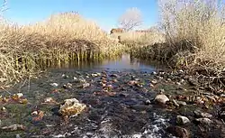
 San Solomon Spring-fed ciénega, near Balmorhea, is in arid West Texas. The springs have a tremendous flow of 22 to 28 million gallons a day. (2009)
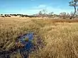 Cloverdale Ciénega in the Bootheel area of southwest New Mexico. This illustrates what an undamaged ciénaga looks like under normal conditions: marsh-like, broad, shallow, slow migrating water through thick vegetation. (2008)
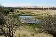 Cienequita, Las Ciénegas, north of Tucson, Arizona. With very little incising, this is a smaller, functioning ciénaga. (2012)
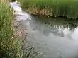
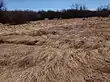 Canelo Hills, Arizona. This is what a healthy ciénaga looks like after a flood, erosion is avoided by plants that lie down and spring back after heavy flows. (2009)
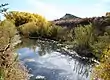 Burro Ciénaga on the Pitchfork Ranch south of Silver City, New Mexico. Today, many of the few remaining ciénagas that still have water look like this, deeply incised by fast flowing water trapped between vertical walls. (2005)
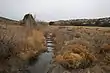 Burro Ciénaga down channel about a quarter mile from the previous photograph. This section is more severely incised and creek-like: narrow rather than wide enough to cover the entire valley floor, historically reaching the toes of the canyon on both sides. (2006)
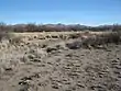 Former San Simon Ciénega on the Arizona/New Mexico Border. Now dead, this ciénaga is beyond any possible recovery due to serious water overdraft, despite determined, long-term government effort. (2010)
Properties
| Look up ciénega or ciénaga in Wiktionary, the free dictionary. |
Ciénegas occur at intermediate elevations (1000-2000 m) and are characterized by saturated, reducing soils with reliable water supply via seepage. Sedges, rushes, and grasses are the dominant plants, with a few trees that can withstand saturated soils, such as willows. Ciénegas trap organic matter from their surroundings, and are thus highly productive ecosystems.[2]
The structure of a natural ciénega is influenced by long-term climatic cycles of wet and dry periods. During dry periods, falling water tables lead to a reduction in vegetation. Prolonged wet periods lead to increased vegetation and trapping of sediment, while brief periods of high rainfall may lead to carving of gullies. Runaway gully growth, as can occur when vegetation is artificially removed (e.g., by overgrazing), can lead to channelization and loss of the ciénega.[3]
Recognition
Although under recognized, ciénagas have been important for a very long time. “In general, most prehistoric agricultural settlements were located near ciénagas or on the floodplains of the major perennial streams where irrigated agriculture could be practiced.”[4] It was not until 1984 that Dean A. Hendrickson and W. L. Minckley alerted academics in the Southwest to the importance of its overlooked ciénagas. So-called progress and development often led to the unfortunate thinking that "the only good wetland was a drained wetland."
Since their rather inauspicious invitation for further study, the effort to understand and restore ciénagas has gradually gained prominence. Although not the exclusive view, but suggestive of how ciénagas were typically thought of historically, is this exchange, a 1940s-era conversation between Richard Bradford's narrator, Joshua Arnold, and his school chum in the New Mexico novel, Red Sky at Morning
"I didn't know there was this much water around Sagrado," I said. "The Sagrado River's been dry since I got here." "This is a cienega," Parker said. "It's some kind of underground spring, but it's not good for anything but making the ground wet. Costs a fortune to drain it or pump it off, and Cloyd isn't about to spend money for things like that."[5]
This attitude is changing with the publication of numerous peer-reviewed papers and studies. In one area of study, scholars have been coring ciénagas over the past two decades and have reconstructed the evolution of the aridlands of the Southwest. Although their true numbers will never be know, there were likely thousands of healthy ciénagas in the area prior to the arrival of the Europeans.
Importance
The importance of ciénagas is staggering. They are critical for birds and other animals; “more than 70 percent of land animals use riparian areas.”[6] Wetlands in the Southwest occupy under two percent of the land area and have an exorbitant impact on the region; wetlands are critical habitat for "at risk" species; at least 19 percent of Arizona's endangered, threatened or candidate species for protection are dependent on wetland environments. “There are over 1,900 species listed under the Endangered Species Act as either threatened or endangered; 1,320 are in the United States and of that number, 573 are animal species (the rest are plants) and of them, about half live in aquatic environments; ...beyond species of concern, simply by providing differential habitat in otherwise arid regions, desert ciénegas and riparian corridors may increase regional biodiversity by up to 50%."[7] Although their numerical count is less dramatic, ninety-five percent of ciénaga habitat is dry today.
Abundant archeology surrounds ciénagas; they harbor data about Native American land use; contain fossil remains of prehistoric animals now extinct; proxy data such as pollen, charcoal and isotopes preserved in ciénaga sediment that are now cored and studied and appear to be the best way to uncover not only their past but the history of the Southwest; as "keystone ecosystems," they have a vastly disproportionate relevance to their surroundings; and, not unimportantly, there is their beauty.
Ciénagas also provide the source for “ecosystem services,” an emerging restoration notion in which market value is attributed to various environmental functions provided by landowners for the public good and for which they have historically not been compensated: filtering rain and snowmelt; slowing seasonal flood pulses to reduce stream channel degradation and to otherwise slow soil erosion; promoting groundwater recharge; and delivering clean, safe drinking water at a far lower cost than it would take to build infrastructure to replace these services.
A long-forgotten indication that there used to be far more water in the Southwest and suggesting there were more ciénagas here than we'll ever know is the sumidero. The word in standard Spanish means “a sewer, drain or gutter,” but to early settlers and ranchers it meant “a mask well or sinkhole.”[8] They were dangerous, 10 to 20 feet across, deep, spring-like traps that showed up unexpectedly on plains or bare, alkali-covered flats with too much mud to flow and too much water to dry up. The thin, upper mud surface of a sumidero was baked dry, absent any indication to distinguish it from nearby safer ground. If a man, horse or cattle stepped onto the treacherous surface of a sumidero, they could instantly perish without ever being recovered. These sinkholes were often fenced. Although mostly lost, stories persist of cowboys and animals being sucked into the mud under the crisp surface of sumideros. These dangerous features of a formerly less arid Southwest are long gone but offer insight into the future of ciénagas, absent efforts to save these few nearly forgotten waters.
Causes of deterioration
There are two perspectives for studying the history of ciénagas, either how ciénagas developed, aggraded and were established, or how they were degraded after the arrival of Europeans to the Southwest. While the scientists have only recently begun the daunting task of uncovering the natural processes that established ciénagas, the explanation for their losses and deterioration is clear.
Ciénaga habitat was established through natural process over a period of some 10,000 years. In the 200 years following the arrival of European settlers, a disconnected series of mostly human-caused events conspired to transform the Southwest from a depositional environment to an erosional one, severely lowering groundwater tables, drying the land and resulting in a bewilderingly high number of ciénaga losses. This period can be thought of as "The Great Ciénaga Disappearance." Most ciénaga habitat has simply disappeared, leaving only a “skeleton” or thin stream of water that, absent a concentrated restoration effort, will soon blink out.
Their disappearance began with the arrival of Spanish livestock in what is now the American Southwest. These early settlers introduced sheep, which trampled ciénaga banks, disrupting the habitat and over-using water. These flocks became the dominant domestic animal in the northern frontier of Spain's North American colonies. Arriving with Juan de Oñate and his party of colonists in 1598 and retained by the Pueblo Indians after they revolted and sent Spaniards south in 1680, the raising of sheep persisted well after the 1692 Spanish reconquista. By the late 1700s it was a major regional industry. By 1756, one commissioned source put the number of sheep held by Spanish and Puebloan herders in New Mexico at 115,737. Sheep outnumbered cattle almost seven to one. While these early numbers are always suspect, by the 1820s as many as two million sheep covered New Mexico, and, by 1865, the numbers of sheep more than doubled with a ratio of sheep to cattle ballooning to 37 to 1 or 4,600,000 sheep to only 125,000 cows.[9]
Ciénaga dewatering continued with the over-trapping of beavers in the 1820–1830s. In a surprisingly short period, beavers were virtually eradicated from the American Southwest. Beaver dams soon failed from neglect, and channels began to form in the soft sediments trapped behind these barriers. Over time, the channels became increasingly connected and the process of channeling, down-cutting and dewatering of ciénagas took hold.
Shallow, flatland watercourses and adjacent riparian zones shifted from complex systems dominated by ponds, multiple channels, ciénagas, marshes and otherwise wide wetlands plentiful in fish and wildlife into simple, incised, single-thread channels with narrow strips of riparian vegetation. Beavers are capable of building "... as many as twenty dams per mile of stream. The dams smear the water across the landscape, so to speak, transforming a rushing rivulet into a series of broad pools and mucky wetlands linked by shallow, multiply branched channels. Indians regarded them as a fine thing ..."[10]
With the demise of the beaver came a major alteration of the Western landscape. The beaver (Castor Canadensis) is one of the few animals with the capacity to reshape its environment significantly; because of its engineering talents and sociability, the Apaches believed the beaver to be the wisest of all creatures ... Thousands of [beaver lodges] once dotted the Gila, forming reservoirs that helped control seasonal flooding and provide wetlands for migrating birds. The wholesale destruction of the beaver disrupted ... ecological relationships, and for the first-time erosion became a major problem as the river flooded unchecked, while animal populations fluctuated wildly as their habitats began to disappear.[11]
The loss of huge numbers of beaver by intense trapping was a (major) step in converting dynamic and complex stream and river ecosystems into the relatively static and simplified water delivery systems that we see today.[12]
The beaver-laden Southwest was far different from the one we know today. At the intersection of Interstate 10 and the Gila River south of Phoenix, Arizona, hundreds of beaver were trapped out, where today only barren desert remains. "People could walk in the shade from the headwaters of the Gila River in New Mexico all the way to Yuma, Arizona,"[13] where the formerly perennial river emptied into the Colorado River. In 1891, two Silver City, New Mexico, men floated on the Gila River from its headwaters to Yuma.[14] Due to the monumental changes to its habitat and desertification, the American Southwest of today is merely an artifact of what it was 150 years ago.
Many ciénagas also suffered damage when early settlers re-contoured the broad ciénaga canyon flats in a misguided attempt to prevent the flooding of their agricultural fields. Remnant ditches, dikes and dams persist today throughout many of the abandoned canyon fields near some of the few remaining and poorly functioning ciénagas. The resulting channelization and concentrated water flow have reduced these historic wetlands to a fraction of their original size and have inadvertently created deep, high-walled incisions that have progressively worsened — though most farming has long-since ceased — and exacerbated the region-wide lowering of the groundwater table, further dewatering formerly wetted ciénagas.
The damage to ciénagas caused by sheep, followed by the decimation of beaver and the conversion of open land to agricultural fields was then worsened with the overstocking of cattle and the explosion of hugely ill-suited cattle herds by the 1880s. Ciénagas were trampled and dewatered, grasslands neutered, erosion accelerated, and other damage followed. While the ratio of sheep to cattle was thirty-seven to one a mere 25 years earlier, by 1890, cattle numbers had spiked to 1,809,400, and the ratio narrowed to nearly two to one, 3,492,800 sheep to 1,809,400 cattle and ultimately flipped to fifteen to one (1,540,000 cattle to 110,000 sheep).[9]
Ciénaga habitat in an otherwise arid, resource constrained landscape was the first source of water to be used by Hispanics and Anglos for their livestock. As early as the 1680s, Pima Indians in Sonora were complaining that Spanish livestock were so common that watering places were drying out. The effects of long-term, sustained grazing — particularly during drought episodes — caused reduced plant cover and vigor; increased runoff and sediment transport; fostered desertification, which worsened the deepening of incised channels; triggered water table declines and further loss of wetland vegetation, thereby making ciénagas and their surrounds among the most abused sites on earth.
Then the severe weather and drought of the late 1880s and early 1890s exacerbated the degradation of the re-contoured and overstocked landscape devoid of beavers that had already seen grass and wetlands severely degraded. After the unusually dry summer in 1886, the consistently below-zero temperatures in the winter of 1887 were so bitter that cattlemen could not have imagined the late spring that followed. The weather worsened as mild winter rains and unusually dry summers peaked with two years of drought in 1891–1893, bringing disaster with livestock mortality reaching 75 percent.
Springs and ciénagas long thought to be permanently wetted went completely dry. The 1878 report to the United States Geological Survey (USGS) by John Wesley Powell warned that the arid, short-grass plains were poorly suited for intensive grazing because of recurrent drought and so little rain west of the hundredth meridian. But nobody listened; boomers, runners, and raiders prevailed as developers’ disingenuous “boosterism” — "The rain follows the plow."[15] — consistently outpaced natural resources. House-high piles of cattle bones and a severely damaged landscape scarred the Southwest and foretold the price to be suffered by future generations. The persistence of drought and uneven rains as a cause of de-watering in the Southwest is worsening due to accelerating climate change.
Compounding the over-trapping of beaver, over-stocking of sheep and cattle, the draining and conversion of land for agriculture, and drought, fire suppression by the recent European occupants of the Southwest may have caused as much harm as these others combined.
Caused by lightning originating in pre-monsoonal thunderstorms and from purposeful ignition by Native Americans, fire was a significant influence in the evolution of southwestern ecosystems in which many plant species are fire-adapted. But since the arrival of Europeans in the Southwest, fire has been suppressed to such an extent — on average from occurring every 8 to 10 years to now occurring almost never, except for forest fires — that woody plants have out-competed grasses and transformed historic grasslands into a landscape dominated by trees and shrubs.
The majority of grass biomass consists of roots that lie beneath the surface while trees and other woody plants is just the opposite, above ground. Before the arrival of Europeans, Southwest grassland fires occurred so often that they killed many woody plant species, yet merely topped off and strengthened the health of grasses. This frequent fire regime was a long time, natural intervention allowing grasses to out-compete woody plants. This transition from grasslands to woodlands helped finish off many ciénagas and severely reduces the size of those that remained.[16]
Benefits
The benefits ciénagas provided the lands of the Southwest were enormous. They not only provided a rich habitat for plant and animal life, but the combination of lateral spreading of flood pulses and abundant above-ground vegetation lessened the erosive potential of floods and protected the softer surface sediments. Broad ciénaga surfaces dispersed seasonal flood pulses into sheet flows and prevented the channelization fostered by the combination of insults outlined above. Ciénagas and grasslands formerly captured large amounts of sediment suspended in sheet flows that for the past 200 years have eroded barren soils in today's gully-washers, flowing through ever-deepening incisions or arroyos throughout the Southwest. The result is heightened flash flooding and exaggerated channel discharge that has reduced water tables and further exacerbated the already severe dewatering of ciénagas.
The combination of these forces transformed the entire Southwest as desertification reduced ciénaga area to a mere fraction — five percent — of its historic habitat. The dominant land surface process in the Southwest today is stream scour, the opposite of sheet flow or slow moving water that was the norm just 200 years ago. Absent coordinated intervention to preserve these dwindling habitats, the future of ciénagas is bleak: "[s]ince 1900, erosion associated with post-settlement channelization, and drawdown of local water tables have dried up most ciénaga environments."[1]
Development
The mechanisms underlying ciénaga development — natural and long evolving, as opposed to those of their destruction, which were abrupt and extreme — began as the earth cooled and the last ice age came to a close. The Holocene Epoch began 11,500 years ago.
While ciénagas had been an important part of the American Southwest for thousands of years, until recently little was known about them. Their importance and the extent of their disappearance and damage were meaningfully identified only 30 years ago with the publication of the paper that called for and resulted in a flurry of follow-up studies. In their seminal 1984 Ciénegas - Vanishing Climax Communities of the American Southwest, ichthyologists Dean A. Hendrickson and W. L. Minckley focused on ciénagas in southeast Arizona and, for the first time, gave them prominence on the scholarly radar:
We hypothesize the ciénaga to be an aquatic climax community ...[that] act as traps for organic materials and nutrients in the aquatic ecosystem, and must be remarkably productive...In light of their continuing disappearance, cultural histories, and importance to aquatic faunas and floras, these dwindling, valuable, as yet little-understood ecosystems constitute a resource which merits further investigation...[17]
The technology that would be used to answer this call and the history it would uncover could have hardly been imagined. Hendrickson and Minckley's appeal for further study prompted a string of increasingly complex investigations. Diverse and ongoing scholarship is looking into ciénagas and associated landscape questions, not just changes in habitat composition and structure brought on by European arrival, but answers to the questions of growth rates, as well as when and how ciénagas, and in turn the Southwest, developed. Scientists are in the process of understanding their history, vegetation composition, the implications of climate change, and, importantly, the means and potential for restoration, conservation and management. They are slowly uncovering the evolution of these unique, one-of-a-kind, aridland, fresh water habitats. Interwoven, multidisciplinary approaches call on botany, geology, geophysics, geography and other branches of knowledge to bring this elusive prehistory into focus. These studies are teasing out answers by investigating the record of sediment build-up, the profile of ciénaga-drawn cores containing stable sedimentary isotopes, pollen, microscopic charcoal or fire remnants, elemental fractions of organic materials and identifying the sources of the organic matter buried within the sediments. The following time line summarizes several of these studies:
21,000 BP — The period of the last glacial maximum when ice sheets throughout the globe were at their maximum extension of the earth, glaciers were at their thickest and the sea levels were at their lowest. The American Deserts were forested, with large pluvial lakes punctuating and rivers flowing across the landscape. The Pleistocene or Ice Age ended, and the Holocene Epoch began.
11,500 BP — Stream flows remained strong, capable of moving rocks and cobbles, precluding establishment of most ciénagas, save those few along more protected reaches.
8000 BP — Furthest time for which scientists have collected continuous evidence of ciénaga materials to determine when and how ciénagas developed. Water flows remained robust and still prevented the wholesale establishment of ciénagas, a time "when winter precipitation was minimal, fire was rare."[18] "However we do have evidence from the American Deserts of ciénegas deep into the last ice age."[7]
7200 BP — Initial stabilization of ciénaga occurred as flows slowed, allowing formation of wetlands. "During most of the past 7,068 years this environment has been slowly aggrading...[although] this generally slow process of accumulating sediments is punctuated by periods of rapid development."[7]
6000 BP — Onset of El Niño/La Niña-Southern Oscillation, warm and cool recurring, alternating, quasi-periodic climate pattern that occurs across the tropical Pacific Ocean and accounts for much of the fire variability in the Southwest.
5300 BP — Before this period, woody plants dominated the uplands with "fire episode frequency below (1 fire every 200 years)" and even more infrequent when winter precipitation was low. The transition to grasslands began around this time; after this period, fire frequency increased to "1.3 every 100 years."[18]
7200 – 4100 BP — Fine grain sediment increases, suggesting permanent and prolonged annual wetting, stable ciénagas that went through at least three steady states after initial stabilization:
· 6300 – 6000 BP
· 4700 – 4000 BP
· 1600 – 750 BP
4500 BP — Due to heavy moisture, a period of river system down-cutting in the Southwest; fire frequency increased to "2.1 fires/100 years"[18] or one fire every 48 years.
4100 – 2400 BP — 1,700-year dry interval period where ciénaga water permanence severely lessened, and fire frequency decreased to only "1 fire every 100 years."[18]
4100 – 1300 BP — Dominated by grasses, this period was similar to present day. Ciénagas were stable with the transitional shift from arid habitat to wetter conditions, trending toward more aquatic states—conditions that persisted until European settlement.
3400 BP — Earliest prehistoric presence of human activity is demonstrated by the presence of corn (Zea) pollen at Animas Creek ciénaga in New Mexico. Zea pollen, found in various sediment cores pulled from ciénagas throughout the region, establishes Native Americans' use of ciénagas and their surrounds.
1300 - 750 BP — Stability in upland vegetation and ciénaga surfaces was established, "water ponding and stagnation of the water was likely occurring,"[19] sedges and cattails dominated, and fire frequency increased to "2.6 fire episodes per 100 years"[18] or a fire, on average, every 38 years.
1692 CE — The Spanish arrived in large numbers after the reconquista, 200 years after Columbus.
1700s CE — The dramatic decline of charcoal corresponds with the appearance of filaree (Erodium cicutarium) pollen in sediment cores about 1795, which in turn corresponds with the establishment of Camp Grant in 1860, almost 200-years after Spanish colonization in 1692. Coring shows frequent burning of some ciénagas before European contact, and six ciénagas record an increase in dung fungus (Sporormiella) spores common among grazing animals increased during the so-called (post-contact) historic period in response to the introduction of livestock. “The change in fire history is linked to human activity by the prehistoric presence of the pollen of weeds and corn (Zea) in the ciénegas."[20]
1800 CE — Before 1800, fire frequency had increased, on average, to one fire every decade, but abruptly decreased with the displacement of native agriculture by European settlement, triggering accelerated post-settlement transformation of wetland vegetation back to woody species.
There are several undeniable conclusions from these studies:
- · Between 6000 BP and arrival of Europeans in the Southwest, fire frequency steadily increased.
- · The arrival of Europeans with livestock immediately reduced fire frequency, both by Native American and natural ignition, put an end to tree or woody plant burning and started the trend in which trees out-compete grass, which continues today.
- · Weather, El Niño-Southern Oscillation (ENSO) and La Niña are "the primary driver[s] for fire occurrence and frequency in borderland desert grassland systems"[18] and are key to understanding the severe weather variability so unique to the Southwest. This extreme variability overshadows all other factors influencing fire, vegetation and ciénaga conditions.
Future
The global warming occurring in the American Southwest is going to worsen:
Human activities are already changing the climate of the American West...[T]he Rocky Mountain Climate Organization and the Natural Resources Defense Council [report] drawn from 50 scientific studies, 125 other government and scientific sources, and [its] own new analyses, documents that the West is being affected more by a changed climate than any other part of the United States outside of Alaska. When compared to the 20th Century average, the West has experienced an increase in average temperature during the last five years that is 70 percent greater than the world as a whole.[21]
"[T]he borderlands are going to get warmer...minimum winter and maximum summer temperatures are likely to increase in the southwestern U.S, and precipitation is likely to decease... ENSO variability will likely increase fire frequency..."[18] The National Oceanic and Atmospheric Administration's (NOAA) 22nd Annual State of the Climate report for 2011 found the Arctic was warming about twice as fast as the rest of the planet, and heat-trapping greenhouse gas concentrations continued to rise with the global average atmospheric concentration of carbon dioxide going over 390 parts per million for the first time. As of this writing, it is over 400 parts per million. The United Kingdom's Met Office suggests "event attribution science" — which is in its early stages and must be stated in terms of probability rather than certainty — posits that the 2011 heat waves in Texas and England were, respectively, 20 and 60 times more likely than they would have been 50 years ago because of climate change.
Global warming is dramatically increasing extreme weather. Ciénaga restoration and management will become increasingly more challenging because this forthcoming barrage of heat and drought will occur in a context of ever-deepening incisions and a landscape degraded and stripped of grasses with groundwater lower than ever. Pile extreme weather events — less but heavier rains, worse storms — atop these existing conditions, and the tasks of reversing the 200-year erosive trend that has bankrupted these systems and recapturing stable ciénaga dynamics become formidable. It is worth mention, that as carbon sequestration gains recognition in the challenges posed by climate change, ciénagas serve as “sweet spots” for carbon capture.
The question of fire or burning at water sources and on the landscape had long been an unresolved one, some arguing that fires were uncommon and others suggesting that fires were frequent and played a significant role in the evolution and maintenance of desert systems before the arrival of Europeans. Conventional wisdom was driven by the Pristine Myth, an idealized Thoreauvian view of a natural wilderness in which Native Americans barely made a perceptible disturbance and were merely another natural element of the region.
But it is now understood that Native Americans caused significant modifications to habitats by clearing of forest and intentional burning. Fire scientists and ecologists have identified fire scars in trees, charcoal layers in lake sediment and, most recently, charcoal and other materials from desert ciénaga sediments — together, establishing Native American intentional use of fire.
The examination of microscopic charcoal from six ciénagas in the Sonoran Desert in Arizona and Sonora, Mexico, "document a marked expansion of wetland taxa — particularly woody plants — about 200 years ago at the beginning of the historic periods."[19] This study summarizes a series of abrupt changes in fire and sediment content during the transition from the prehistoric to historic period and also summarizes findings compatible with this change:
- · "Historic documents indicate frequent burning of southern Arizona vegetation by Indians..."[20]
- · "...the historic reduction of fire frequency is a general conclusion of most tree-ring studies of fire frequency in the region."[20]
- · Before the turn of the century, "...desert wetlands were described as boggy, open environments with riparian gallery forests situated above the waterlogged soils of the valley bottoms."[19]
- · "The presence of charred seeds and fruits of wetland plants in prehistoric sediment establishes burning of the ciénaga itself,"[20]
- · "...prior to the historic period, burning was frequent enough to exclude most woody plants,"[20]
- · "Prehistoric agricultural utilization of the ciénagas is demonstrated by the presence of corn (Zea) and pre-Columbian weeds... [t]he change in fire history is linked to human activity by the prehistoric presence of pollen of weeds and corn in the ciénegas,"[20]
- · "...Borderland ciénagas record marked expansion of the pollen wetland taxa during the historic period and these expansions follow or are accompanied by decreased charcoal abundance,"[20]
- · “All sites appear to record increases in charcoal percentages up to the time of the historic decline... [t]he decline[s] in sediment charcoal indicates a dramatic decrease in fire frequency during the historic period,"[20]
- · "...[r]educed fire frequency caused the historic transformation of wetland vegetation in the Sonoran Desert (to woody plants),"[20]
The oldest corn (Zea) pollen found in ciénagas is dated 3400 BP, suggesting Native Americans used ciénagas and the surrounding area for crops. The appearance of European-introduced filaree is preceded by a dramatic decline in charcoal. Among woody plants, Gooding's willow pollen, so ubiquitous today along riparian corridors in the Southwest, increased most consistently.
These recent studies have expanded the initial Hendrickson and Minckley work and demonstrate even more convincingly the peril facing this unique and long-used aridland water: "Springs ecosystems are among the most structurally complicated, ecologically and biologically diverse, productive, evolutionary provocative, and threatened ecosystems on earth."[21]
Desert wetlands, or ciénegas, have been overlooked in conservation priority assessments...[and] some authors have argued for increasing their conservation priority. Ciénegas have exceptional value for avian diversity... [as] more species of migrating birds in [the Southwest] ... use isolated ciénegas than sites along a continuous riparian corridor. The conservation potential for ciénegas in arid and semi-arid ecosystems is incredibly high considering the wealth of ecosystem services these environments provide when functioning properly (and the) conservation value that will grow under the conditions expected with global climate change...Given the realities of how to best spend limited conservation dollars and resources, conservation and restoration of extant ciénegas may prove to be the greatest net benefit in terms of current endangerment.[7]
Cultural implications
The cultural implications of water must also be kept in mind. Water has long played a sacred and functional role in the lives of pre-Columbian Native Americans. Springs, seeps and ciénagas held a unique place in their world: "...springs were simply alive. They were points where creation came to the surface and spilled out, where a hand could actually reach forward to feel the emergence."[22] Many of these First Nations People, including Zuni and Hopi, believe they emerged from the underworld through springs. These special places were their emergence point.
Statistical occurrence
It is likely that there were many hundreds of long lost ciénagas when the Southwest was Indian country, although there are only 155 identified or named ciénagas since the European arrival in the entire International Four Corners Region of the Southwest — that is, Arizona and New Mexico in the United States and Chihuahua and Sonora in Mexico.[23] As awareness of their importance grows, their numbers will invariably increase. There were also named ciénagas that can no longer be located, many unnoticed and unnamed, and an unknown number of scattered ciénagas existing on private land but secreted because landowners fear detection will adversely affect their property rights. As shown in Table 2 below, fewer than half (44%) of known ciénagas are functional or restorable, while 56% have no potential for restoration or are dead.
|
| |||||||||||||||||||||||||||||||||||
| Table 1. Distribution of Known Ciénagas by State in the US and Mexico | Table 2. Current Condition of Known Ciénagas |
In late 2018, as part of his effort to create a wetland action plan for the state of New Mexico, retired former New Mexico botanist Robert Sivinski discovered via satellite an additional 119 small ciénagas in New Mexico.[24] This surprising number of previously unidentified or unstudied ciénagas suggests there are far more to be found. Although there is no way to know with certainty, it is now believed that there were many hundreds, if not thousands, of ciénagas in the Southwest before the arrival of the Spanish colonialists and that as much as 95 percent of ciénaga habitat has been lost.
Preservation
While these endangered habitats have suffered a rapid and staggering degree of loss, the few remaining ciénagas are salvageable, usable and even profitable if restored. Widespread spontaneous recovery is unlikely without concerted restoration efforts. Ciénagas will heal on their own only in "... small areas where local geomorphic structure is particularly favorable to wetland development."[25] But “...once established, ciénega vegetation appears highly resistant to removal by seasonal flooding, instead the vegetation has a stabilizing effect on the stream bed and becomes a sink for sediment trapping and water retention [and carbon sequestration]."[7] Large scale recovery will likely require a significant shift in awareness among the general public, some rethinking by bureaucrats and a much-needed broadening of politician's land ethics to include habitat in order to return these desert watercourses to their authentic state.
In Arizona, as of 2012, there were 82 plants and animals that were either endangered, threatened or proposed for listing under the Endangered Species Act. Of these, 15 are directly associated with ciénagas. "[A]ridland springs function as 'keystone ecosystems,' exerting vastly disproportionate impacts on regional ecology, evolutionary processes, and sociocultural economics in relation to their size."[7] If one has only limited funds for habitat improvement and hope to meaningfully aid "at risk" animals and plants, nearly 20 percent of an entire region's troubled species can be helped by investing in ciénaga restoration. Despite the increasing extent of ciénaga habitat loss and severe damage to the few ciénagas that remain, there are still those that have long persisted and arguably represent the single most important resource for the maintenance and preservation of regional biodiversity
Ciénagas have long played an unheralded role in the biota of the International Four Corners Region and there are now ongoing efforts to inventory, restore and preserve them. A working ciénaga inventory is maintained at the University of Texas Austin with access to numerous papers, google maps and other ciénaga materials:
See also
- La Cienega
- Dry lake – Basin or depression that formerly contained a standing surface water body
- Salt pan (geology) – Flat expanse of ground covered with salt and other minerals
- Oasis – Isolated source of fresh water in a desert
- Grass valley – A meadow within a forested and relatively small drainage basin
References
- Minckley and Brunelle (2007). "Paleohydrology and Growth of a Desert Ciénega". Journal of Arid Environments. 69 (3): 420–431. Bibcode:2007JArEn..69..420M. doi:10.1016/j.jaridenv.2006.10.014.
- Hendrickson, D.A.; Minckley, W.L. (1985). "Ciénegas: Vanishing Climax Communities of the American Southwest". Desert Plants. 6: 131–175.
- Lisenby, P.E.; Tooth, S.; Ralph, T.J. (2019). "Product vs. process? The role of geomorphology in wetland characterization". Science of the Total Environment. 663: 980–991. doi:10.1016/j.scitotenv.2019.01.399.
- Bahre, Conrad Joseph (1991). A Legacy of Change: Historic Human Impact on Vegetation of the Arizona Borderlands. Tucson: University of Arizona Press.
- Bradford, Richard (1968). Red Sky at Morning. Philadelphia and New York: J. B. Lippincott Company.
- McCool, Daniel (2012). River Republic: The Rise and Fall of America's Rivers. New York: Columbia University Press.
- Brunelle, Minckley, & Turner (2012). "A Paleoenvironmental Framework for Understanding the Development, Stability and State-Changes of Cienegas in the American Deserts". Merging Science and Management in a Rapidly Changing World: Biodiversity and Management of the Madrean Archipelago. III: 1–5.CS1 maint: multiple names: authors list (link)
- Cobos, Ruben (2003). A Dictionary of New Mexico and Southern Colorado Spanish. Santa Fe: Museum of New Mexico Press.
- Dunmire, William D. (2013). New Mexico's Spanish Livestock Heritage. Albuquerque: University of New Mexico Press.
- Mann, Charles (2011). 1492, Uncovering the New World Columbus Created. New York: Alfred A. Knopf.
- McNamee, Gregory (1994). Gila, The Life and Death of an American River. New York: Orian Books.
- Wild, Cathryn (2011). Beaver as a Climate Adaptation Tool: Concepts and Priority Sites in New Mexico. Seventh Generation.
- Felger, Richard. E-mail communication, 23 September 2012.
- "Silver City Enterprise". 24 April 1891.
- Stegner, Wallace (1954). Beyond the Hundredth Meridian: John Wesley Powell and the Second Opening of the West. Boston: Houghton Mifflin Company.
- See YouTube: Aridland Ciénagas for a drone-filmed survey of a surviving ciénaga undergoing restoration.
- Hendrickson and Minckley (1984). "Cienegas - Vanishing Climax Communities of the American Southwest". Desert Plants. 6 (3): 131–175.
- Brunelle, Minckley, Blissett, Cobabe, and Guzman (2010). "A ~8000 Year Fire History from an Arizona/Sonora Borderland Cienega". Journal of Arid Environments. 74: 475–481. doi:10.1016/j.jaridenv.2009.10.006.CS1 maint: multiple names: authors list (link)
- Minckley; et al. (2009). "Isotopic Analysis of Wetland Development in the American Southwest". The Holocene. 19 (5): 737–745. Bibcode:2009Holoc..19..737M. doi:10.1177/0959683609105297.
- Davis; et al. (2002). "The Transformation of Sonoran Desert Wetlands Following the Historic Decrease of Burning". Journal of Arid Environments. 50 (3): 393–412. Bibcode:2002JArEn..50..393D. doi:10.1006/jare.2001.0914.
- Stevens and Meretsky (2008). Aridland Springs in North American, Ecology and Conservation. Tucson: University of Arizona Press.
- Childs, Craig (2001). The Secret Knowledge of Water, Discovering the Essence of the American Desert. New York, Boston, London: Back Bay Books.
- Cole and Cole (2015). "An Overview of Aridland Cienagas with Proposals for the Classification, Restoration, and Preservation". New Mexico Botanist (Special Issue, No. 4).
- Sivinski, Robert (December 2018). "Wetlands Action Plan, Arid-land Spring Cienegas of New Mexico". New Mexico Environment Department, Surface Water Quality Bureau.
- Heffernan, James B. (2008). "Wetlands as an Alternative Stable State in Desert Streams" (PDF). Ecology. 89 (5): 1261–1271. doi:10.1890/07-0915.1. hdl:10161/8360. PMID 18543620.