Cirque Peak (British Columbia)
Cirque Peak is a 2,531-metre (8,304-foot) mountain summit located in the Cayoosh Range of the Lillooet Ranges, in southwestern British Columbia, Canada. It is situated 19 km (12 mi) northeast of Pemberton, 4.4 km (3 mi) west-northwest of Cayoosh Mountain, 3.2 km (2 mi) east-southeast of Mount Gardiner, and immediately east of the Place Glacier.[3] The mountain's cirque name, which describes the shape of the peak, was submitted by mountaineer Karl Ricker of the Alpine Club of Canada.[4] The name was officially adopted on January 23, 1979, by the Geographical Names Board of Canada.[2] Precipitation runoff from the peak drains into tributaries of the Fraser River.
| Cirque Peak | |
|---|---|
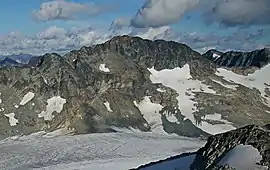 Cirque Peak, western aspect | |
| Highest point | |
| Elevation | 2,531 m (8,304 ft) [1] |
| Prominence | 476 m (1,562 ft) [1] |
| Parent peak | Mount Oleg (2587 m)[1] |
| Coordinates | 50°25′00″N 122°34′53″W [2] |
| Geography | |
 Cirque Peak Location in British Columbia  Cirque Peak Cirque Peak (Canada) | |
| Location | British Columbia, Canada |
| Parent range | Cayoosh Range Lillooet Ranges Coast Mountains |
| Topo map | NTS 92J7 |
| Climbing | |
| Easiest route | Scrambling |
Climate
Based on the Köppen climate classification, Cirque Peak is located in a subarctic climate zone of western North America.[5] Most weather fronts originate in the Pacific Ocean, and travel east toward the Coast Mountains where they are forced upward by the range (Orographic lift), causing them to drop their moisture in the form of rain or snowfall. As a result, the Coast Mountains experience high precipitation, especially during the winter months in the form of snowfall. Temperatures can drop below −20 °C with wind chill factors below −30 °C. The months July through September offer the most favorable weather for climbing Cirque Peak.
Climbing Routes
Established climbing routes on Cirque Peak:[1]
- East Face Gully
- North Ridge via Place Glacier - class 3
References
- "Cirque Peak". Bivouac.com. Retrieved 2019-11-27.
- "Cirque Peak". Geographical Names Data Base. Natural Resources Canada. Retrieved 2019-11-27.
- "Cirque, British Columbia". Peakbagger.com. Retrieved 2019-11-27.
- "Cirque Peak". BC Geographical Names.
- Peel, M. C.; Finlayson, B. L.; McMahon, T. A. (2007). "Updated world map of the Köppen−Geiger climate classification". Hydrol. Earth Syst. Sci. 11. ISSN 1027-5606.
External links
- Weather forecast: Cirque Peak