Ring Mountain (British Columbia)
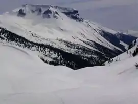
Ring Mountain, also called Crucible Dome, is a tuya in the Mount Cayley volcanic field, British Columbia, Canada. It has a horseshoe shaped crater, located on the east side of the upper Squamish River. Outcrops on Ring Mountain's western side contain highly variable, fine-scale jointing and are locally broken down into many small spires and knobs. The age of Ring Mountain is unknown, but probably formed during the Fraser Glaciation like most tuyas in Canada.[2]
| Ring Mountain | |
|---|---|
 | |
| Highest point | |
| Elevation | 2,192 m (7,192 ft) [1] |
| Prominence | 260 m (850 ft) [1] |
| Coordinates | 50°13′17″N 123°17′58″W [1] |
| Geography | |
 Ring Mountain Location in British Columbia | |
| Location | British Columbia, Canada |
| Parent range | Pacific Ranges |
| Geology | |
| Age of rock | Unknown |
| Mountain type | Tuya |
| Volcanic arc/belt | Canadian Cascade Arc Garibaldi Volcanic Belt |
| Last eruption | Unknown |
| Climbing | |
| First ascent | 1968 John Clarke[1] |
See also
References
- "Ring Mountain". Bivouac.com. Retrieved 2007-02-03.
- "Ring Mountain". Volcanology Laboratory. University of British Columbia. Retrieved 2007-02-03.
External links
This article is issued from Wikipedia. The text is licensed under Creative Commons - Attribution - Sharealike. Additional terms may apply for the media files.