Mount Frederick William
Mount Frederick William is a mountain located at the Queen Reach arm of the Jervis Inlet within the Pacific Ranges of the Coast Mountains in British Columbia Canada. The mountain was named during the 1860 survey by HMS Plumper which charted all of the area and named the mountain after the Prussian Crown Prince Frederick William, who had married Princess Victoria, the eldest child of Queen Victoria and Prince Albert.[1]
| Mount Frederick William | |
|---|---|
 Mt. Frederick William | |
| Highest point | |
| Elevation | 1,818 m (5,965 ft) |
| Prominence | W. of N. end of Princess Royal Reach, New Westminster Land District |
| Coordinates | 50°04′58.3″N 123°52′01.3″W |
| Geography | |
 Mount Frederick William Location in British Columbia | |
| Location | Jervis Inlet , British Columbia, Canada |
| Parent range | Pacific Ranges |
| Topo map | NTS 92/J4 |
This mountain has been given the nickname of Frankenstein for it has the familiar profile of the famous monster's face.
External links
Gallery
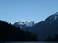 Mt. Frederick William seen from Princess Louisa Inlet at Dusk.
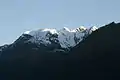 Mt. Frederick William close up
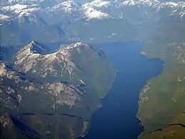 Behind Mt. Frederick William as seen from 20,000 feet (Bowl shape mountain)
References
- Hitz, Charles W.(2003). Through the Rapids - The History of Princess Louisa Inlet, p.54. Sikta 2 Publishing.,Kirkland, WA. ISBN 0-9720255-0-2.
This article is issued from Wikipedia. The text is licensed under Creative Commons - Attribution - Sharealike. Additional terms may apply for the media files.