City of St Kilda
The City of St Kilda was a local government area on Port Phillip, about 5 kilometres (3.1 mi) south of Melbourne, the state capital of Victoria, Australia. The city covered an area of 8.70 square kilometres (3.36 sq mi), and existed from 1855 until 1994.
| City of St Kilda Victoria | |||||||||||||||
|---|---|---|---|---|---|---|---|---|---|---|---|---|---|---|---|
 Location in Melbourne | |||||||||||||||
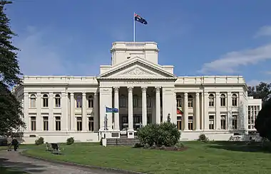 St Kilda Town Hall, on the corner of Carlisle and St Kilda Road | |||||||||||||||
| Population | 45,889 (1992)[1] | ||||||||||||||
| • Density | 5,274.6/km2 (13,661/sq mi) | ||||||||||||||
| Established | 1855 | ||||||||||||||
| Area | 8.70 km2 (3.4 sq mi) | ||||||||||||||
| Council seat | St Kilda | ||||||||||||||
| Region | Melbourne | ||||||||||||||
| County | Bourke | ||||||||||||||
| |||||||||||||||

History
St Kilda was first incorporated as a municipal district on 24 April 1855, and became a borough in April 1863. It was proclaimed a city on 8 September 1890.[2]
Council meetings were first held at the St Kilda Police Station, at St Kilda Junction, before the city's first town hall was built in 1859, on the corner of Grey and Barkly Streets.[3]
A new town hall was built for the city, on the corner of Carlisle Street and Brighton Road. The site was reserved in 1883, selected in 1887, with plans drawn up by architect William Pitt in 1888.[3]
On 22 June 1994, the City of St Kilda was abolished, and, along with the Cities of Port Melbourne and South Melbourne, was merged into the newly created City of Port Phillip.[4]
The council met at the St Kilda Town Hall, at the intersection of St Kilda Road and Carlisle Street, St Kilda. The facility is now the main council chambers for the City of Port Phillip.
Wards
The City of St Kilda was divided into four wards on 5 April 1987, each electing three councillors:[2]
- North Ward
- West Ward
- Centre Ward
- South Ward
Suburbs
The council area was bounded by Fraser and Lorne Streets, Punt Road and Wellington Street/Dandenong Road to the north; Orrong Road, Inkerman Street and Hotham Street to the east, Glen Huntly Road, St Kilda Street and Head Street to the south, and Port Phillip to the west.[5]
Suburbs within the City of St Kilda were:
- Balaclava
- Elwood
- Ripponlea
- St Kilda
- St Kilda East (shared with the City of Caulfield)
Population
| Year | Population |
|---|---|
| 1861 | 6,408 |
| 1901 | 20,542 |
| 1921 | 38,579 |
| 1947 | 58,318 |
| 1954 | 53,301 |
| 1958 | 51,200* |
| 1961 | 52,205 |
| 1966 | 58,179 |
| 1971 | 61,203 |
| 1976 | 51,254 |
| 1981 | 49,366 |
| 1986 | 45,889 |
| 1991 | 45,481 |
* Estimate in the 1958 Victorian Year Book.
References
- Australian Bureau of Statistics, Victoria Office (1994). Victorian Year Book. p. 50. ISSN 0067-1223.
- Victorian Municipal Directory. Brunswick: Arnall & Jackson. 1992. pp. 497–498. Accessed at State Library of Victoria, La Trobe Reading Room.
- "St Kilda Town Hall. Brighton Road (corner Carlisle Street), St Kilda". A Place of Sensuous Resort: Buildings of St Kilda and their People. St Kilda Historical Society. 2005. Retrieved 4 April 2015.
- Australian Bureau of Statistics (1 August 1995). Victorian local government amalgamations 1994-1995: Changes to the Australian Standard Geographical Classification (PDF). Commonwealth of Australia. p. 11. ISBN 0-642-23117-6. Retrieved 16 December 2007.
- Melway - Greater Melbourne Street Directory (22nd edition). Glen Iris, Victoria: Melway Publishing Pty Ltd. 1993. pp. Maps 57, 67. ISSN 0311-3957.
