Elwood, Victoria
Elwood is an inner suburban area of Melbourne, Victoria, Australia, 8 km south of Melbourne's Central Business District. Its local government area is the City of Port Phillip. At the 2011 Census, Elwood had a population of 14,638.
| Elwood Melbourne, Victoria | |||||||||||||||
|---|---|---|---|---|---|---|---|---|---|---|---|---|---|---|---|
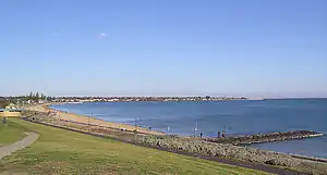 Elwood Beach | |||||||||||||||
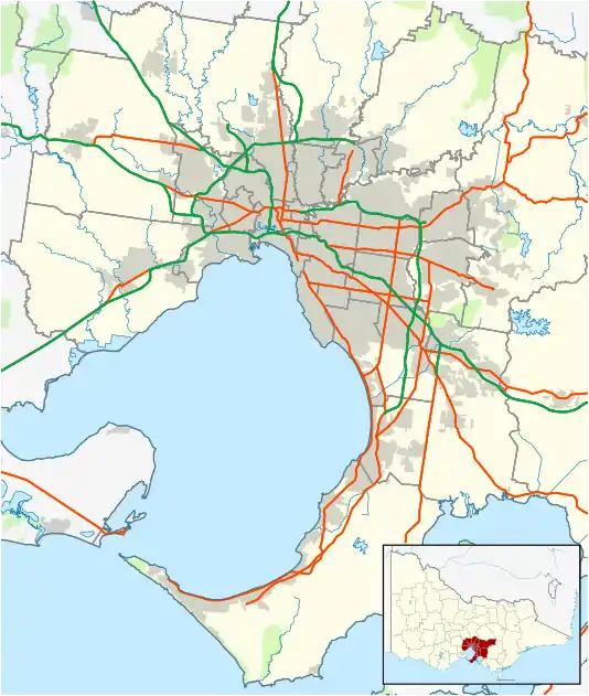 Elwood Location in metropolitan Melbourne | |||||||||||||||
| Coordinates | 37.884°S 144.986°E | ||||||||||||||
| Population | 15,543 (2016 census)[1] | ||||||||||||||
| • Density | 5,980/km2 (15,480/sq mi) | ||||||||||||||
| Established | 1900s | ||||||||||||||
| Postcode(s) | 3184 | ||||||||||||||
| Area | 2.6 km2 (1.0 sq mi) | ||||||||||||||
| Location | 8 km (5 mi) from Melbourne | ||||||||||||||
| LGA(s) | City of Port Phillip | ||||||||||||||
| State electorate(s) | Brighton | ||||||||||||||
| Federal Division(s) | Macnamara | ||||||||||||||
| |||||||||||||||
Elwood Beach is a popular bayside beach destination during summer, where the beaches are used recreationally for windsurfing, cycling, cricket and walking.
The suburb is known for its mix of Edwardian and Interwar architecture character, its beaches and its leafy streets, many of which are lined by London Plane trees.
History

*
Pre-colonial history.
The earliest inhabitants of the area now covered by the City of Port Phillip were the Yalukit Wilum, one of the five clans of the Boon Wurrung, known as the coastal tribe, and who were members of the Kulin nation. They inhabited the swampy areas below Emerald Hill and the sandy-ridged ti-tree covered coastline, which extended from St Kilda to Fishermans Bend (Port Melbourne). The Aboriginal inhabitants knew the St Kilda area as Euro-Yroke a name they used to describe the red-brown sandstone found along the beach. Yalukit Willam: The river people of Port Phillip, provides an Aboriginal history of the area.
Elwood was originally swampland; installation of the Elwood Canal turned it into an area suitable for residential development.
Elwood was initially planned out around the two central geographic features of Elster Creek (now Elwood Canal), and promontory at Point Ormond, once known as Little Red Bluff.
Fires burned for centuries on Point Ormond and it was here the Aboriginal Australians would cook shellfish, signal other clans and burn back country.
Fever brought the first large group of settlers to Elwood, when the desperate immigrant ship Glen Huntley landed at Point Ormond in 1840, flying the fever flag and initiating Victoria's first quarantine station and St Kilda’s first graveyard.
Originally a working middle class suburb in the early part of the 20th century, Elwood has overseen waves of gentrification and is now one of Melbourne's most sought after bayside addresses.
Large period houses, many from the 1920s and 30s with art deco touches, along with proximity to beach and foreshore, have made the area very attractive.
In the late 1970s, like nearby St Kilda, Elwood was known for its nightlife and developed a reputation as a cabaret area. Many of these venues operated out of some of the suburb's quirkier old buildings. As the scene saw a demise in the early 1980s, many buildings, including Maison de Luxe and Moulin Rouge (which operated out of the 1880s mansion "Pladda" built for Captain A. Currie), were subsequently demolished.
Despite its history of adversity, a modern suburb now thrives by the bay in one of Melbourne's most prized locations. Café life in the Elwood village seems a long way from the flood, fire and fever of earlier days. Coloured lorikeets flock to the green corridors of shady trees, a native forest has been planted on the foreshore and the once despised canal area is undergoing rejuvenation as a haven for walkers and cyclists.
Population
In the 2016 Census, there were 15,543 people in Elwood. 65.0% of people were born in Australia. The next most common countries of birth were England 4.9%, New Zealand 2.8%, Ireland 1.1%, United States of America 1.1% and India 1.1%. 76.6% of people spoke only English at home. Other languages spoken at home included Greek 1.5%, Italian 1.4%, Russian 1.1%, Spanish 1.1% and French 1.1%. The most common responses for religion were No Religion 48.4% and Catholic 17.0%.[1]
Local landmarks
Elwood Village consist mainly of the group of shops starting on New Street, through Ormond road to Glen Huntly Road. With many iconic restaurants and cafes, famous beauty shops and pet groomers/shop, and its own traditional boutique barbershop -Le Barbier d’Elwood.
Parks and open space
For such an established leafy suburb, Elwood is highly built up and lacking in open space. The most popular and largest reserves are bayside, including Elwood Beach, Elwood Canal, and Point Ormond Reserve. The beach and canal are known to suffer from litter pollution and the canal has a distinctive smell resulting from the backflow of seaweed. However, the local council has strategies in place to manage these issues.
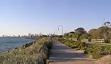 Elwood Beach & Melbourne skyline
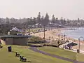 Elwood Beach
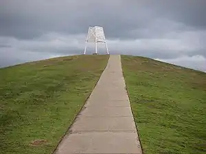 Point Ormond
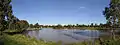 Elsternwick Park
Residential architecture
Elwood is known for its mix of Victorian mansions, Edwardian cottages and interwar apartment buildings. Infill development in recent decades has changed the character of the suburb, however, some examples still remain.
- Sherwood Hall, formerly named "Rotherfield", is a large Victorian (45 room) mansion at 14 Hennessy Avenue. It was built between 1890 and 1891 by David C. Askew of Twentyman & Askew (architects), for Joseph Cowen Syme, who was a co-owner of "The Age" newspaper, for some 12 years. Upon the death of Laura Syme (J.C. Symes' widow) in the 1920s, the mansion was turned into flats. Sherwood Hall is listed in the Port Phillip Heritage Review, 1998.
- Woy Woy is the earliest of a small group of multi-storied modernist flats in Elwood, it is also the earliest of its kind in Melbourne.[2] Built in 1925–1936 the flats were designed by Mewton & Grounds. Woy Woy is located at 77 Marine Parade, Elwood, Victoria, Australia. The design of the apartment block is extremely minimal.[3] The interlocking cubic forms in the design reveal an interest in architect Willem Dudok.[4][5]
- Architect and resident Esmond Dorney, who is best known for his post war Modernist residential work in Tasmania, designed several flats in Elwood in the 1930s including St Kiernan's Flats (51 Ormond Esplanade), Antigone Flats (34 Docker Street) and Winderemere (49 Broadway).[6][7][8]
- La Tourelle flats, 47A Brighton Road, corner of Dickens Street, is one of the many large blocks of interwar flats in the area, around Brighton Road.
- Belmac flats on the corner of Goldsmith Street and Mitford Street 'Belmac', designed by James Wardrop, built in 1943
 La Tourelle flats, 47A Brighton Road, corner of Dickens Street. Designed by architect and resident Esmond Dorney
 Woy Woy, 77 Marine Parade, Elwood, Victoria, Australia. First modernist block of flats in Melbourne. Designed by Mewton & Gounds.
Places of worship
St. Columba's Catholic Church and school, 26 Gelnhuntly Road, opened in 1927.
Elwood Presbyterian, 31A Scott Street.
Elwood Shule, congregation established in 1938, first stage of present building at 39 Dickens Street. Opened 1957.
Education
Elwood houses a number of schools, considering its limited area. There are 2 primary schools, one offers a catholic education. Saint Columba's Primary is located adjacent to the church and has access to a large number of facilities. There is also a large public school, Elwood Primary School. Elwood is also serviced by a local secondary school, Elwood College, previously named Elwood High School.
Sport
Elwood Sailing Club was founded in 1924 as Elwood Sea Canoe Club and has since hosted many national and international championships, including 12m2 Sharpie sailing in the 1956 Melbourne Olympics and the 2005 World Formula Windsurfing Titles. ESC now boasts extensive sailing, training and social facilities and the clubrooms are available to the general public for function hire. Click here for live webcam views of the beach.
Elwood has a full-time lifesaving club.
An active Triathlon club operates in Elwood and the main beach hosts several triathlons each year.
Elwood Park is home to a touch football club, tennis club and croquet club. Between 1881 and 1980 there was Elwood Football Club (soccer), later reforming as Elwood City Soccer Club.
Elwood Bowls club located at Elsternwick Park, in front of the Elsternwick hotel. The demographic of the members are from all ages and the clubhouse is a good venue for your functions.
Transport
The main form of transport is the private automobile and bus. The major roads are on its periphery and include multi-lane Brighton Road, Marine Parade, Barkly Street and Glen Huntly Road.
Elwood is no longer serviced by rail. A tram line connecting St Kilda to Brighton, which operated between 1908 and 1959, ran through Elwood, down Mitford Street. After its closure the route was replaced by bus services.
Elwood is serviced by the Bayside Trail bicycle path. This path is used by commuters and also recreationally and it includes a roller-skating path, used by rollerbladers.
Tram route 67 (Carnegie) runs along the northern boundary of the suburb, along Brighton Road/Nepean Highway to the city or via Elsternwick (past Elsternwick railway station) to Carnegie.
The nearest railway stations are about beyond the northern boundary of the suburb, at either Ripponlea or Elsternwick (both across Brighton Road/Nepean Highway).
Elwood is also served by a number of bus routes:
- Number 630 runs from Ormond Road Elwood to Gardenvale Station, Ormond Station, Huntingdale to Monash University in Clayton.
- Number 923 runs from St Kilda to Elwood, Brighton Beach, Sandringham to Westfield Southland.
- Number 246 runs from Elsternwick railway station, via Elwood, Prahran, South Yarra, Richmond, Collingwood (all via Punt Road) and up to Clifton Hill.
Street names
Many of the streets in Elwood are named after things related to the beach. These streets include Beach Avenue, Spray Street, Wave Street, Tide Street and Foam Street. Other streets in the area are named after famous anglophone writers, essayists and poets, such as Shakespeare Grove, Dickens Street, Milton Street, Wordsworth Street, Byron Street, Keats Street, Tennyson Street, Poets Grove, Ruskin Street and Shelley Street.
Notable residents
- Joe Camilleri
- Rodger Corser
- Louise Crawford
- Teage Ezard
- Vincent Fantauzzo
- Germaine Greer
- Brian Dixon
- Alex Gurney
- Paul Hester
- Mark Holden
- Ken James
- Asher Keddie
- Brad Miller
- Matt Parkinson
- Roland Perry
- Jane Turner
- Ronald Ryan
- Esmond Dorney
- Bridget McKenzie
- Belle Gibson
- Ruth Borgobello
- Jordan Khan
- Sunny Khan
- Sam Wood
Sunsets
Like many of the beaches in Melbourne, Elwood is known for its spectacular sunsets.
 Elwood Beach at dusk
 The Spirit of Tasmania sailing through Port Phillip in dusk seen from Elwood Beach
See also
- City of St Kilda - the former local government area which Elwood was a part
References
- Australian Bureau of Statistics (27 June 2017). "Elwood (State Suburb)". 2016 Census QuickStats. Retrieved 13 April 2018.

- Peterson, R (2005). "A Place of Sensuous Resort: Buildings of St Kilda and their people", www.skhs.org.au/SKHSbuildings/42.htm
- "Spowers Background"
- Peterson, R (2005). "A Place of Sensuous Resort: Buildings of St Kilda and their people", www.skhs.org.au/SKHSbuildings/42.htm
- Neville, G (2010). [modernismus.wordpress.com/modern-idea/], "Melbourne: Woy Woy", viewed 19 April 2014
- "City of Port Phillip Heritage Review" (PDF). City of Port Phillip. City of Port Phillip.
- "City of Port Phillip Heritage Review" (PDF). City of Port Phillip. City of Port Phillip.
- "The Built Heritage". Built Heritage. Built Heritage Pty Ltd.