Colorado State Highway 88
State Highway 88 (SH 88) is a 21.734-mile-long (34.977 km) state highway in Denver and Arapahoe counties within the U.S. state of Colorado. SH 88's northern terminus is at Interstate 70 Business (I-70 Bus.), U.S. Route 40 (US 40) and US 287 in Denver, and the eastern terminus is at SH 83 in Aurora.
| ||||
|---|---|---|---|---|
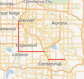
SH 88 highlighted in red | ||||
| Route information | ||||
| Maintained by CDOT | ||||
| Length | 21.734 mi[1] (34.977 km) | |||
| Major junctions | ||||
| North end | ||||
| East end | ||||
| Location | ||||
| Counties | Denver, Arapahoe | |||
| Highway system | ||||
Colorado State Highways
| ||||

Route description
SH 88 is a 21.7 mile (34.9 km) long highway, starting at a cloverleaf intersection at Colfax Avenue (U.S. Route 40) and Federal Boulevard in Denver. It starts as a six lane highway going south with a 35 mph speed limit. It then interchanges with the 6th Avenue Freeway (US 6) before passing through the west Denver neighborhoods. Continuing south, it interchanges at US 285's final exit as a freeway entering Sheridan. It then turns east on Belleview with three lanes in each direction and a 40 mph speed limit. It passes under US 85 and goes through another neighborhood with two lanes in each direction approaching Greenwood Village. The route enters the Denver Tech Center and becomes concurrent with Interstate 25 from exit 199 to exit 197 at Arapahoe Road. SH-88 continues east with a 40 mph speed limit on Arapahoe Road with three lanes in each direction passing through Centennial and north of Centennial Airport with a 55 mph speed limit until it reaches its eastern terminus at Parker Road (State Highway 83) in Foxfield.
History
SH 88 was an original 1920's highway that originally ran along Belleview from Broadway to Parker Road in Greenwood Village. In 1939, it was extended east along Quincy Avenue into the now defunct Lowry Field Bombing Range until 1954. The western extension to Santa Fe (US 85) was completed by 1956.
Cherry creek reservoir construction
Construction of the dam didn't start until 1948. Before that, there was an old wooden bridge that passed over cherry creek until it was destroyed in a fire in which the state abandoned the road. However, state maps still showed the section of Belleview by 1958.
Present day
In 1959, the section along Arapahoe road was added, originally as a gravel road and it wasn't paved until 1961. The section of Federal Blvd in Sheridan was originally signed as SH 75 and was renumbered to SH 88 in 1968. Arapahoe Road didn't become an expressway until it was built east to Peoria Street in 1977 and the final stretch to SH 83 (Parker Rd.) wasn't finished until 1990. The intersection of Arapahoe Road and Parker Road used to have a triple left going from eastbound to northbound and was one of the most congested intersections in the Denver Metro Area. It was later upgraded to an interchange where Parker Road now continues north without stopping. The interchange was completed in 2012.[2]
Major intersections
| County | Location | mi | km | Exit | Destinations | Notes |
|---|---|---|---|---|---|---|
| City and County of Denver | 0.000 | 0.000 | Interchange; Northern terminus, Road continues north as U.S. 287 | |||
| 1.090 | 1.754 | Interchange; access to US 6 east via Fifth Avenue | ||||
| 1.978 | 3.183 | |||||
| Arapahoe | Sheridan | 5.973 | 9.613 | Interchange; signage changes from north/south to east/west | ||
| Englewood | 8.711 | 14.019 | Single-point urban interchange | |||
| Cherry Hills Village–Greenwood Village line | 11.560 | 18.604 | ||||
| Greenwood Village | 14.709 | 23.672 | 199 | Western terminus of concurrency with I-25/ US-87; Eastern terminus of concurrency with Belleview Avenue; I-25 exit 199 | ||
| 15.5 | 24.9 | 198 | Orchard Road | I-25 exit 198 | ||
| 16.7 | 26.9 | 197 | Eastern terminus of concurrency with I-25/U.S.-87; Western end of concurrency with Arapahoe road; I-25 exit 197 | |||
| Aurora | 21.734 | 34.977 | Interchange; eastern terminus | |||
1.000 mi = 1.609 km; 1.000 km = 0.621 mi
| ||||||
References
- "Segment list for SH 88". Retrieved January 21, 2011.
- Salek, Matthew E. "Colorado Routes 80-99". Retrieved November 11, 2020.