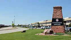
Centennial Airport
Centennial Airport (IATA: APA, ICAO: KAPA, FAA LID: APA) is a public use airport owned by the Arapahoe County Public Airport Authority in the Denver-Aurora metropolitan area, 15 nautical miles (17 mi, 28 km) southeast of downtown Denver, Colorado, United States.[1] Located in Dove Valley,[2] a census designated place in Arapahoe County, the airport's runways extend into Douglas County.[3][4]
Centennial Airport | |||||||||||||||||||
|---|---|---|---|---|---|---|---|---|---|---|---|---|---|---|---|---|---|---|---|
.png.webp) | |||||||||||||||||||
 | |||||||||||||||||||
| Summary | |||||||||||||||||||
| Airport type | Public | ||||||||||||||||||
| Owner | Arapahoe County Public Airport Authority | ||||||||||||||||||
| Serves | Denver–Aurora Metropolitan Area, Colorado | ||||||||||||||||||
| Location | Dove Valley CDP, Colorado | ||||||||||||||||||
| Elevation AMSL | 5,885 ft / 1,794 m | ||||||||||||||||||
| Coordinates | 39°34′12″N 104°50′58″W | ||||||||||||||||||
| Website | http://www.centennialairport.com/ | ||||||||||||||||||
| Maps | |||||||||||||||||||
 FAA airport diagram | |||||||||||||||||||
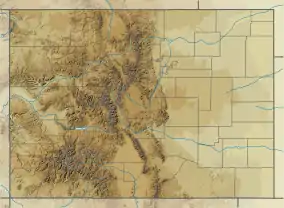 APA Location of airport in Colorado  APA APA (the United States) | |||||||||||||||||||
| Runways | |||||||||||||||||||
| |||||||||||||||||||
| Statistics (2018) | |||||||||||||||||||
| |||||||||||||||||||
Facilities
The airport opened on May 12, 1968, as Arapahoe County Airport, and was renamed on July 13, 1984. The new name reflects Colorado's admission to the Union as the 38th state in 1876, the centennial of the United States Declaration of Independence.
In 1985 a new control tower was built. It is an international airport with continuous U.S. Customs services and is one of the busiest general aviation airports in the United States with an average of 874 operations per day.[5] The Federal Aviation Administration control tower and associated air traffic control services are continuous; Runway 35R has a Category I Instrument Approach.
Centennial Airport covers 1,400 acres (567 ha) at an elevation of 5,885 feet (1,794 m). It has three asphalt runways: 17L/35R is 10,000 by 100 feet (3,048 x 30 m); 17R/35L is 7,001 by 77 feet (2,134 x 23 m); 10/28 is 4,800 by 75 feet (1,463 x 23 m).[1] In 2018 the airport had 337,947 aircraft operations, average 925 per day: 89% general aviation, 10% air taxi, and 2% military. 840 aircraft were then based at this airport: 569 single-engine, 104 multi-engine, 147 jet, and 20 helicopter.[1]
Key Lime Air has its corporate headquarters on the airport property.[6][7] Air Methods previously did as well;[8] it moved to Greenwood Village, Colorado in 2017.[9]
The National Plan of Integrated Airport Systems for 2011–2015 categorized the airport as a reliever airport.[10]
Airlines and destinations
Passenger
| Airlines | Destinations |
|---|---|
| Denver Air Connection | Grand Junction (suspended March 20, 2020)[11] |
Cargo
| Airlines | Destinations |
|---|---|
| AirNet Express | Columbus–Rickenbacker, Des Moines, Portland (OR) |
| Western Air Express | Salt Lake City |
Accidents near APA
- On November 19, 1979, a Cessna 500 Citation I operated by National Jet industries, a cargo flight, crashed on an improper IFR approach to runway 34 due to icing conditions. Two of the three occupants died.[12]
- On March 27, 1980, a Beechcraft Super King Air operated by Lufkin Industries crashed 13 miles east of APA near Parker, Colorado due to ice accumulation on the wings. Both crew and all eight passengers died.[13]
References
- FAA Airport Form 5010 for APA PDF. Federal Aviation Administration. Effective May 31, 2012.
- "Dove Valley Business Park". Dove Valley Metropolitan District. Retrieved 2015-03-11. The postal designation of Englewood, a city located some 7 miles (11 km) west of Dove Valley CDP, is used in the airport's mailing address. Centennial Airport: Contact Details Archived April 2, 2015, at the Wayback Machine. Retrieved 2015-03-11.
- "2010 CENSUS - CENSUS BLOCK MAP: Dove Valley CDP, CO" (Archive). U.S. Census Bureau. Retrieved on April 1, 2015.
- "Directions" (). Centennial Airport. Retrieved on April 1, 2015.
- FlightAware > Resources > Airport > Centennial Airport (Denver, Colorado) [KAPA/APA]
- "About." Key Lime Air. Retrieved on April 2, 2015. "Based at Centennial Airport in Englewood Colorado, Key Lime Air is strategically positioned to be able to offer convenient service to either the West coast, Central or East coast of the United States." and "13252 E. Control Tower Rd. Englewood, CO 80112"
- "Arapahoe County Assessor". Arapahoe County. Retrieved 2 April 2015.
- "Contact Us". Air Methods. Retrieved April 2, 2015.
Corporate Headquarters 7211 S. Peoria Englewood, CO 80112 and Air Methods' headquarters are located on the north side of Centennial Airport in Englewood – West side of Peoria Street, just south of Easter Avenue
- Miler, Ben (2017-05-25). "After sale is complete, Air Methods is moving its headquarters". Denver Business Journal. Retrieved 2018-09-14.
- "2011–2015 NPIAS Report, Appendix A" (PDF). National Plan of Integrated Airport Systems. Federal Aviation Administration. October 4, 2010. Archived from the original (PDF, 2.03 MB) on 2012-09-27.
- "Denver Air Connection Temporarily Suspends Service". September 4, 2020.
- Accident description for N555AJ at the Aviation Safety Network
- Accident description for N456L at the Aviation Safety Network
External links
![]() Media related to Centennial Airport at Wikimedia Commons
Media related to Centennial Airport at Wikimedia Commons
- Centennial Airport, official site
- Centennial Airport (APA) at Colorado DOT airport directory
- Aerial image as of April 2002 from USGS The National Map
- FAA Airport Diagram (PDF), effective January 28, 2021
- FAA Terminal Procedures for APA, effective January 28, 2021
- Resources for this airport:
- FAA airport information for APA
- AirNav airport information for KAPA
- ASN accident history for APA
- FlightAware airport information and live flight tracker
- NOAA/NWS weather observations: current, past three days
- SkyVector aeronautical chart, Terminal Procedures