Colorado State Highway 83
State Highway 83 (SH 83) is a state highway that runs from SH 21 interchange in northern Colorado Springs to SH 2 at Leetsdale Dr. / Colorado Blvd. in Denver.
| ||||
|---|---|---|---|---|
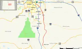 Map of central Colorado with SH 83 highlighted in red | ||||
| Route information | ||||
| Maintained by CDOT | ||||
| Length | 56.50 mi[1] (90.93 km) | |||
| Major junctions | ||||
| South end | ||||
| North end | ||||
| Location | ||||
| Counties | El Paso, Douglas, Arapahoe, Denver | |||
| Highway system | ||||
Colorado State Highways
| ||||

Route description
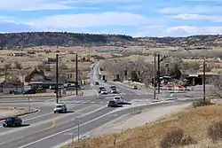
SH 83 begins in far northeastern Colorado Springs, at the intersection of CO 21 and Interquest Parkway. From there it becomes a 60 mph rural highway, continuing northward through rural countryside for 30 miles to Franktown, through a tree heavy and hilly portion of Douglas County, and passing the eastern border of Castlewood Canyon State Park, then intersecting SH 86. The route becomes a six lane divided expressway at Bayou Gulch Road with a 55 mph speed limit. The route continues on and enters the City of Parker and the southeastern portion of the Denver Metropolitan Area, where it interchanges with E-470. After, it enters Arapahoe County just north of E-470 and descends into Centennial where it interchanges with Arapahoe Road, which recently was upgraded to a grade-separated interchange. SH 83 continues as a 55 mph expressway as it enters Aurora, intersecting Hampden Avenue and Interstate 225. The route enters suburban Aurora, and it becomes more of a city street, dropping to a 45 mph speed limit and narrowing to 4 lanes. It soon enters the Cherry Creek district of Denver and ends at Colorado Boulevard/SH 2.
History
The first 21 miles, originally extending from SH 115 to SH 21, was relinquished to and is now maintained by the city of Colorado Springs; with signage being inconsistent within the city limits. The highway began in southern Colorado Springs at the intersection of SH 115 and the terminus of SH 83 which is called South Academy Blvd. It ran east then north through the center of the city, where it turned into North Academy Blvd after the intersection with Pikes Peak Avenue, the north-south demarcation point for the city. Several city intersections were upgraded with overpasses (at Proby Parkway, US 24 and Woodmen Road) to avoid making this just another city street. The highway continued north then northwest through the city, and then just before connecting to I-25 it turned directly north and the speed limit increases to 55 mph. After paralleling I-25 for several miles, it turned east as it overlays Interquest Parkway to an interchange with SH 21.
Major intersections
All exits are unnumbered.
| County | Location | mi[2] | km | Destinations | Notes |
|---|---|---|---|---|---|
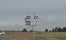
| El Paso | Colorado Springs | 0.0 | 0.0 | Southern terminus; road continues south as Interquest Parkway; northern terminus of SH 21 | |
| Black Forest | 7.5 | 12.1 | Eastern terminus of SH 105 | ||
| Douglas | Franktown | 30.0 | 48.3 | ||
| Parker | 41.0 | 66.0 | South end of freeway; E-470 exit 5 | ||
| Arapahoe | Aurora–Centennial– Foxfield tripoint | 44.5 | 71.6 | Interchange; Eastern Terminus of SH-88 | |
| Aurora | 49.0 | 78.9 | Hampden Avenue east | ||
| 49.5 | 79.7 | Vaughn Way / Dam Road | |||
| 50.0 | 80.5 | North end of freeway; I-225 exit 4 | |||
| Arapahoe–Denver county line | Aurora–Denver line | 51.5 | 82.9 | ||
| City and County of Denver | 56.5 | 90.9 | Northern terminus | ||
1.000 mi = 1.609 km; 1.000 km = 0.621 mi
| |||||
References
- "Segment list for SH 83". Retrieved 2007-05-12.
- "Highway Data Explorer". Colorado Department of Transportation. Archived from the original on September 10, 2012. Retrieved November 20, 2014.