Columbia Falls, Montana
Columbia Falls is a city along the Flathead River in Flathead County, Montana, United States. The population was 4,710 at the 2010 census. Columbia Falls has been ranked as one of the best and safest places to live in Montana.[4][5][6]
Columbia Falls | |
|---|---|
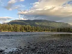 View of the Flathead River from River's Edge Park. | |
 Location of Columbia Falls, Montana | |
| Coordinates: 48°22′13″N 114°11′20″W | |
| Country | |
| State | |
| County | Flathead |
| Government | |
| • Mayor | Donald Barnhart |
| • City Manager | Susan Nicosia |
| Area | |
| • Total | 2.20 sq mi (5.70 km2) |
| • Land | 2.20 sq mi (5.69 km2) |
| • Water | 0.00 sq mi (0.01 km2) |
| Elevation | 3,087 ft (941 m) |
| Population | |
| • Total | 4,688 |
| • Estimate (2019)[3] | 5,876 |
| • Density | 2,672.12/sq mi (1,031.89/km2) |
| Time zone | UTC−7 (Mountain (MST)) |
| • Summer (DST) | UTC−6 (MDT) |
| ZIP code | 59912 |
| Area code(s) | 406 |
| FIPS code | 30-16600 |
| GNIS feature ID | 0806934 |
| Website | City website |
History
Despite the name "Columbia Falls", there are no falls on any nearby river.[7] A first settler desired the name "Columbia", and the element "Falls" was tacked onto the name in order to avoid postal repetition with the already-named Columbus, Montana.[8]
The Montana Veterans Home in Columbia Falls has served veterans since 1896.[9] Its current housing facility was opened by Montana Governor Forrest H. Anderson at an official dedication ceremony in 1970.[10] An E. M. Viquesney statue of a World War I doughboy was moved to the front of the Veterans' Home in 1972. The statue "originally stood in Kalispell in the Main Street median in front of the Flathead County Courthouse."[11]
Geography
The City of Columbia Falls is located 1 mile from the Flathead National Forest, 15 miles from Kalispell, MT and 17 miles from Glacier National Park.[12][13]
According to the United States Census Bureau, the city has a total area of 2.05 square miles (5.31 km2), all land.[14]
Demographics
| Historical population | |||
|---|---|---|---|
| Census | Pop. | %± | |
| 1910 | 601 | — | |
| 1920 | 611 | 1.7% | |
| 1930 | 637 | 4.3% | |
| 1940 | 637 | 0.0% | |
| 1950 | 1,232 | 93.4% | |
| 1960 | 2,132 | 73.1% | |
| 1970 | 2,652 | 24.4% | |
| 1980 | 3,112 | 17.3% | |
| 1990 | 2,942 | −5.5% | |
| 2000 | 3,645 | 23.9% | |
| 2010 | 4,688 | 28.6% | |
| 2019 (est.) | 5,876 | [3] | 25.3% |
| U.S. Decennial Census[15] 2015 Estimate[16] | |||
2010 census
At the 2010 census there were 4,688 people, 1,863 households, and 1,215 families living in the city. The population density was 2,286.8 inhabitants per square mile (882.9/km2). There were 1,994 housing units at an average density of 972.7 per square mile (375.6/km2). The racial makup of the city was 94.4% White, 0.2% African American, 1.8% Native American, 0.4% Asian, 0.3% from other races, and 2.9% from two or more races. Hispanic or Latino of any race were 2.8%.[2]
Of the 1,863 households 35.0% had children under the age of 18 living with them, 47.9% were married couples living together, 12.9% had a female householder with no husband present, 4.5% had a male householder with no wife present, and 34.8% were non-families. 28.8% of households were one person and 11% were one person aged 65 or older. The average household size was 2.47 and the average family size was 3.02.
The median age was 35.6 years. 26% of residents were under the age of 18; 8.5% were between the ages of 18 and 24; 26.8% were from 25 to 44; 25.3% were from 45 to 64; and 13.2% were 65 or older. The gender makeup of the city was 48.1% male and 51.9% female.
2000 census
At the 2000 census there were 3,645 people, 1,400 households, and 966 families living in the city. The population density was 2,402.9 people per square mile (925.9/km2). There were 1,470 housing units at an average density of 969.1 per square mile (373.4/km2). The racial makup of the city was 96.27% White, 0.25% African American, 1.23% Native American, 0.49% Asian, 0.08% Pacific Islander, 0.41% from other races, and 1.26% from two or more races. Hispanic or Latino of any race were 1.84%.[17]
Of the 1,400 households 36.3% had children under the age of 18 living with them, 52.0% were married couples living together, 12.1% had a female householder with no husband present, and 31.0% were non-families. 25.7% of households were one person and 11.0% were one person aged 65 or older. The average household size was 2.52 and the average family size was 3.06.
The age distribution was 28.3% under the age of 18, 8.1% from 18 to 24, 28.6% from 25 to 44, 21.5% from 45 to 64, and 13.4% 65 or older. The median age was 36 years. For every 100 females there were 99.2 males. For every 100 females age 18 and over, there were 97.4 males.
The median household income was $31,128 and the median family income was $40,794. Males had a median income of $32,109 versus $20,023 for females. The per capita income for the city was $14,355. About 12.5% of families and 17.1% of the population were below the poverty line, including 25.8% of those under age 18 and 4.0% of those age 65 or over.
Arts and culture
Heritage Days is an annual celebration of the town's history and heritage. It occurs on the last weekend of July. Activities include Boogie to the Bank, Wildcat Endowment Auction, a parade and carnival, basketball tournament, a barn dance, car show, rodeo, and the running of wild horses through town on Highway 2.[18]
Night of Lights Parade is an annual December holiday parade.[19]
Columbia Falls has a public library, a branch of the Flathead County Library.[20]
Columbia Falls Community Market is a farmers market held weekly every Thursday from 5pm - 8pm from the second Thursday in May until the last Thursday in September.[21][22] The market offers live music, food trucks, local produce, locally brewed beer and a rock climbing wall.[22][23][24]
Parks and recreation
River's Edge Park has over 900 ft (270 m) of river frontage on Flathead River and occupies 28 acres (11 ha). The park has paved walking trails, open meadows, bathroom facilities and a family fly fishing pond.[25]
Pinewood Park Aquatic Center is a public swimming facility located on 4th Ave West. The park also has a basketball court, children's play area, picnic tables and swings.[26]
Government
The government system of Columbia Falls consists of a City Council with six councilmen and a mayor, elected to four-year terms.[27]
Education
Schools in Columbia Falls School District Six include Columbia Falls High school, Columbia Falls Junior High School, Glacier Gateway Elementary School, and Ruder Elementary School. School District Six has a approximately 2,400 students.[28] In 2019 voters approved a $37 million school bond which will fund a new Glacier Gateway Elementary School, a 25,000 square foot addition to the Ruder Elementary School, a security upgrade for the Junior High School and new multi-use sports fields.[29][30]
Transportation
U.S. Highway 2 runs through Columbia Falls. The North Fork Road (S-486) begins at the junction to U.S. Highway 2 in Columbia Falls and runs to the Canadian border.[31]
Commercial airline service is offered at Glacier Park International Airport located approximately 8 miles south of Columbia Falls.[32][33]
The Columbia Falls area is served by Amtrak's Chicago-Portland/Seattle Empire Builder, with stops located nearby in Whitefish and West Glacier.[34]
Media
Columbia Falls is served by Hungry Horse News.[35] The city is also part of the Missoula media market, which covers a seven-county area of northwestern Montana.
KHNK 95.9 FM, (Outlaw Country) and KRVO 103.1 FM are commercial radio stations located in Columbia Falls, broadcasting to the Kalispell-Flathead Valley, Montana, area. KHNK airs a country music format and KRVO airs an adult alternative format.[36][37]
Notable people
- Douglas Cordier, educator and politician
- Anthony Kurta, retired US Navy Admiral[38]
- Glenn Roush, politician[39]
- Braxton Mitchell, member of the Montana House of Representatives
- Mel Ruder, Pulitzer Prize winner and publisher emeritus of The Hungry Horse News[40]
- Matt Regier, politician and businessman[41]
Points of interest
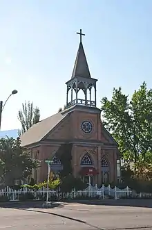
- St. Richard's Church. Built in 1891 and listed on the National Register of Historic Places.[42]
- Soldier's Home Historic District. Built in 1895 the facility houses and provides subsistence to veterans and their spouses.[43]
- Flathead River Bridge
See also
- List of cities and towns in Montana
References
- "2019 U.S. Gazetteer Files". United States Census Bureau. Retrieved July 26, 2020.
- "U.S. Census website". United States Census Bureau. Retrieved December 18, 2012.
- "Population and Housing Unit Estimates". United States Census Bureau. May 24, 2020. Retrieved May 27, 2020.
- Flynn, Liz (October 6, 2019). "The 20 Best Places to Live in Montana". Money Inc. Retrieved November 27, 2020.
- "Montana's 10 Safest Cities of 2020". SafeWise. July 1, 2020. Retrieved November 27, 2020.
- "The 10 Safest Cities In Montana For 2020". HomeSnacks. Retrieved November 27, 2020.
- "Geographic names". Forest History Society. Archived from the original on June 18, 2019. Retrieved July 3, 2019.
- "YESTERDAYS: THE REAL STORY BEHIND THE NAME, 'COLUMBIA FALLS'". Hungry Horse News. Retrieved July 4, 2019.
- "Montana Veterans' Home - Columbia Falls". Montana Department of Public Health & Human Services - Senior & Long Term Care. Retrieved February 6, 2014.
- Montana Veterans Home (1970). History and future of Montana Veterans' Home, Columbia Falls, Montana. Columbia Falls, MT. Retrieved February 6, 2014.
- "Columbia Falls, Montana Viquesney Doughboy Statue". The E. M. Viquesney Doughboy Database. Retrieved February 6, 2014.
- "Community Profile". City of Columbia Falls Montana. Retrieved December 6, 2020.
- "Columbia Falls to Flathead NF distance".
- "US Gazetteer files 2010". United States Census Bureau. Archived from the original on July 2, 2012. Retrieved December 18, 2012.
- United States Census Bureau. "Census of Population and Housing". Retrieved July 14, 2016.
- "Population Estimates". United States Census Bureau. Archived from the original on October 19, 2016. Retrieved July 14, 2016.
- "U.S. Census website". United States Census Bureau. Retrieved January 31, 2008.
- https://www.columbiafallschamber.org/heritage-days/
- "Night of Lights 2018". Columbia Falls Area Chamber of Commerce. Retrieved November 26, 2020.
- "Montana Public Libraries". PublicLibraries.com. Retrieved June 14, 2019.
- "Columbia Falls Community Market". Columbia Falls Area Chamber of Commerce. Retrieved December 4, 2020.
- "The Market". web1. Retrieved December 4, 2020.
- PETERSON, CHRIS (June 17, 2020). "Community Market sees leadership change". Hungry Horse News. Retrieved December 4, 2020.
- Perez, Vanessa (May 14, 2020). "Columbia Falls Community Market opens for season". KECI. Retrieved December 4, 2020.
- "River's Edge Park". City of Columbia Falls Montana. Retrieved November 26, 2020.
- "Pinewood Park Aquatic Center". City of Columbia Falls Montana. Retrieved December 4, 2020.
- "Mayor & City Council". City of Columbia Falls Montana. Retrieved November 26, 2020.
- "Columbia Falls School District 6 – Home of the Wildcats". Retrieved January 7, 2021.
- "Columbia Falls School Bond Projects Moving Forward". Flathead Beacon. June 9, 2020. Retrieved January 7, 2021.
- "Columbia Falls Voters Approve $37 Million School Bond". Flathead Beacon. October 9, 2019. Retrieved January 7, 2021.
- "North Fork Road Study".
- "Driving Distance from FCA to Columbia Falls, MT". www.travelmath.com. Retrieved January 7, 2021.
- "Glacier Park International Airport". Columbia Falls Area Chamber of Commerce. Retrieved January 7, 2021.
- "Airport & Amtrak make Columbia Falls and Glacier Park Accessible". Columbia Falls Area Chamber of Commerce. Retrieved January 7, 2021.
- "Hungry Horse News". hungryhorsenews.com. Retrieved November 26, 2020.
- "95.9 Outlaw Country". 95.9 Outlaw Country. Retrieved November 26, 2020.
- "KRVO The River 103.1 FM Columbia Falls MT USA". StreamingTheNet. Retrieved January 7, 2021.
- "Anthony M. Kurta > U.S. DEPARTMENT OF DEFENSE > Biography". www.defense.gov. Retrieved January 21, 2021.
- "Glenn Roush Obituary (1934 - 2020) - Great Falls Tribune". www.legacy.com. Retrieved January 21, 2021.
- "Mel Ruder: Montana's first Pulitzer winner, dies at 85". Helena Independent Record. Retrieved November 27, 2020.
- "Matt Regier - Montana Environmental Information Center - MEIC". meic.org. Retrieved November 28, 2020.
- "NPGallery Asset Detail". npgallery.nps.gov. Retrieved January 7, 2021.
- Military.com, 31 Jul 2020 (July 31, 2020). "Montana State Veteran Benefits". Military.com. Retrieved January 7, 2021.
External links
| Wikimedia Commons has media related to Columbia Falls, Montana. |
Municipalities and communities of Flathead County, Montana, United States | ||
|---|---|---|
| Cities | 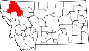 Flathead County map | |
| CDPs | ||
| Unincorporated communities | ||
| Indian reservation | ||
| Ghost town | ||
| Footnotes | ‡This populated place also has portions in an adjacent county or counties | |
| ||