Cook, Nebraska
Cook is a village in Johnson County, Nebraska, United States. The population was 321 at the 2010 census.
Cook, Nebraska | |
|---|---|
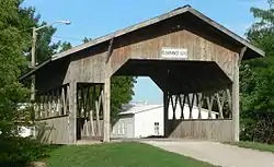 The 1989 Duane Carman bridge in Cook is the only covered bridge in Nebraska.[2] | |
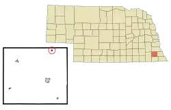 Location of Cook, Nebraska | |
| Coordinates: 40°30′38″N 96°9′41″W | |
| Country | United States |
| State | Nebraska |
| County | Johnson |
| Area | |
| • Total | 0.17 sq mi (0.45 km2) |
| • Land | 0.17 sq mi (0.45 km2) |
| • Water | 0.00 sq mi (0.00 km2) |
| Elevation | 1,053 ft (321 m) |
| Population | |
| • Total | 321 |
| • Estimate (2019)[5] | 302 |
| • Density | 1,745.66/sq mi (674.56/km2) |
| Time zone | UTC-6 (Central (CST)) |
| • Summer (DST) | UTC-5 (CDT) |
| ZIP code | 68329 |
| Area code(s) | 402 |
| FIPS code | 31-10390[6] |
| GNIS feature ID | 0828307[7] |
History
Cook was founded in 1888 when the Missouri Pacific Railroad was extended to that point.[8][9] It was named for Andrew Cook, the original owner of the town site.[10]
Geography
Cook is located at 40°30′38″N 96°9′41″W (40.510526, -96.161506).[11]
According to the United States Census Bureau, the village has a total area of 0.17 square miles (0.44 km2), all land.[12]
Demographics
| Historical population | |||
|---|---|---|---|
| Census | Pop. | %± | |
| 1900 | 278 | — | |
| 1910 | 387 | 39.2% | |
| 1920 | 360 | −7.0% | |
| 1930 | 354 | −1.7% | |
| 1940 | 305 | −13.8% | |
| 1950 | 332 | 8.9% | |
| 1960 | 313 | −5.7% | |
| 1970 | 328 | 4.8% | |
| 1980 | 341 | 4.0% | |
| 1990 | 333 | −2.3% | |
| 2000 | 322 | −3.3% | |
| 2010 | 321 | −0.3% | |
| 2019 (est.) | 302 | [5] | −5.9% |
| U.S. Decennial Census[13] | |||
2010 census
At the 2010 census,[4] of 2010, there were 321 people, 145 households and 89 families residing in the village. The population density was 1,888.2 inhabitants per square mile (729.0/km2). There were 169 housing units at an average density of 994.1 per square mile (383.8/km2). The racial makeup of the village was 95.0% White, 1.2% Asian, 2.2% from other races, and 1.6% from two or more races. Hispanic or Latino of any race were 3.1% of the population.
There were 145 households, of which 26.9% had children under the age of 18, 47.6% were married couples living together, 10.3% had a female householder with no husband present, 3.4% had a male householder with no wife present, and 38.6% were non-families. 34.5% of all households were made up of individuals, and 13.8% had someone living alone who was 65 years of age or older. The average household size was 2.21 and the average family size was 2.80.
The median age was 44.4 years. 23.7% of residents were under the age of 18; 8.8% were between the ages of 18 and 24; 18.3% were from 25 to 44; 31.1% were from 45 to 64; and 18.1% were 65 years of age or older. The sex makeup of the village was 47.7% male and 52.3% female.
2000 census
At the 2000 census,[6] there were 322 people, 159 households and 86 families residing in the village. The population density was 1,854.9 per square mile (731.3/km2). There were 175 housing units at an average density of 1,008.1 per square mile (397.5/km2). The racial makeup of the village was 99.38% White, 0.31% Native American, and 0.31% from two or more races. Hispanic or Latino of any race were 1.24% of the population.
There were 159 households, of which 20.8% had children under the age of 18, 47.8% were married couples living together, 5.0% had a female householder with no husband present, and 45.3% were non-families. 42.1% of all households were made up of individuals, and 28.3% had someone living alone who was 65 years of age or older. The average household size was 2.03 and the average family size was 2.80.
18.9% of the population were under the age of 18, 5.6% from 18 to 24, 19.6% from 25 to 44, 24.8% from 45 to 64, and 31.1% who were 65 years of age or older. The median age was 48 years. For every 100 females, there were 76.0 males. For every 100 females age 18 and over, there were 75.2 males.
The median household income was $28,594 and the median family income was $34,545. Males had a median income of $29,750 and females $18,750. The per capita income was $18,204. About 2.2% of families and 6.8% of the population were below the poverty line, including none of those under age 18 and 20.8% of those age 65 or over.
References
- Duggan, Joe. "Cook: Making the transition to keep town alive", Lincoln Journal Star, March 1, 2008. Retrieved June 28, 2013.
- Duggan, Joe. "Cook: Making the transition to keep town alive", Lincoln Journal Star, March 1, 2008. Retrieved June 28, 2013.
- "2019 U.S. Gazetteer Files". United States Census Bureau. Retrieved July 26, 2020.
- "U.S. Census website". United States Census Bureau. Retrieved June 24, 2012.
- "Population and Housing Unit Estimates". United States Census Bureau. May 24, 2020. Retrieved May 27, 2020.
- "U.S. Census website". United States Census Bureau. Retrieved January 31, 2008.
- "US Board on Geographic Names". United States Geological Survey. October 25, 2007. Retrieved January 31, 2008.
- "Cook, Hall County". Center for Advanced Land Management Information Technologies. University of Nebraska. Retrieved 14 August 2014.
- Burr, George L. (1921). History of Hamilton and Clay Counties, Nebraska, Volume 1. S.J. Clarke Publishing Company. p. 121.
- "Profile for Cook, NE". ePodunk. Retrieved August 14, 2014.
- "US Gazetteer files: 2010, 2000, and 1990". United States Census Bureau. February 12, 2011. Retrieved April 23, 2011.
- "US Gazetteer files 2010". United States Census Bureau. Archived from the original on January 12, 2012. Retrieved June 24, 2012.
- "Census of Population and Housing". Census.gov. Retrieved June 4, 2015.
Municipalities and communities of Johnson County, Nebraska, United States | ||
|---|---|---|
| City | Map of Nebraska highlighting Johnson County | |
| Villages | ||
| Unincorporated communities | ||
| ||
| Authority control |
|
|---|
