Johnson County, Nebraska
Johnson County is a county in the U.S. state of Nebraska. As of the 2010 United States Census, the population was 5,217.[1] Its county seat is Tecumseh.[2] The county was formed in 1855, and was organized in 1857.[3][4][5] It was named for Richard Mentor Johnson, who was Vice President of the United States from 1837 to 1841.[6]
Johnson County | |
|---|---|
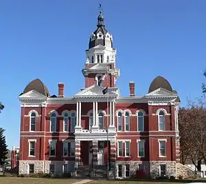 Johnson County Courthouse in Tecumseh | |
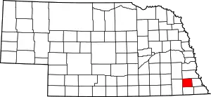 Location within the U.S. state of Nebraska | |
 Nebraska's location within the U.S. | |
| Coordinates: 40°24′N 96°16′W | |
| Country | |
| State | |
| Founded | 1855 (founded) 1857 (organized) |
| Named for | Richard Mentor Johnson |
| Seat | Tecumseh |
| Largest city | Tecumseh |
| Area | |
| • Total | 377 sq mi (980 km2) |
| • Land | 376 sq mi (970 km2) |
| • Water | 0.7 sq mi (2 km2) 0.2%% |
| Population | |
| • Estimate (2017) | 5,185 |
| • Density | 13.8/sq mi (5.3/km2) |
| Time zone | UTC−6 (Central) |
| • Summer (DST) | UTC−5 (CDT) |
| Congressional district | 3rd |
| Website | johnsoncounty |
In the Nebraska license plate system, Johnson County is represented by the prefix 57 (it had the fifty-seventh-largest number of vehicles registered in the county when the license plate system was established in 1922).
Geography
The terrain of Johnson County consists of low rolling hills whose flattened tops are mostly used for agriculture. The Big Nemaha River flows southeastward through the central part of the county.[7] The county has a total area of 377 square miles (980 km2), of which 376 square miles (970 km2) is land and 0.7 square miles (1.8 km2) (0.2%) is water.[8] It is the fourth-smallest county in Nebraska by area.
Adjacent counties
- Otoe County - north
- Nemaha County - east
- Pawnee County - south
- Gage County - west
- Lancaster County - northwest
Demographics
| Historical population | |||
|---|---|---|---|
| Census | Pop. | %± | |
| 1860 | 528 | — | |
| 1870 | 3,429 | 549.4% | |
| 1880 | 7,595 | 121.5% | |
| 1890 | 10,333 | 36.1% | |
| 1900 | 11,197 | 8.4% | |
| 1910 | 10,187 | −9.0% | |
| 1920 | 8,940 | −12.2% | |
| 1930 | 9,157 | 2.4% | |
| 1940 | 8,662 | −5.4% | |
| 1950 | 7,251 | −16.3% | |
| 1960 | 6,281 | −13.4% | |
| 1970 | 5,743 | −8.6% | |
| 1980 | 5,285 | −8.0% | |
| 1990 | 4,673 | −11.6% | |
| 2000 | 4,488 | −4.0% | |
| 2010 | 5,217 | 16.2% | |
| 2017 (est.) | 5,185 | [9] | −0.6% |
| US Decennial Census[10] 1790-1960[11] 1900-1990[12] 1990-2000[13] 2010-2013[1] | |||
As of the 2000 United States Census,[14] there were 4,488 people, 1,887 households, and 1,254 families in the county. The population density was 12 people per square mile (5/km2). There were 2,116 housing units at an average density of 6 per square mile (2/km2). The racial makeup of the county was 93.54% White, 0.11% Black or African American, 0.40% Native American, 2.67% Asian, 0.02% Pacific Islander, 1.96% from other races, and 1.29% from two or more races. 2.87% of the population were Hispanic or Latino of any race.
There were 1,887 households, out of which 29.60% had children under the age of 18 living with them, 58.10% were married couples living together, 5.50% had a female householder with no husband present, and 33.50% were non-families. 29.90% of all households were made up of individuals, and 17.70% had someone living alone who was 65 years of age or older. The average household size was 2.35 and the average family size was 2.92.
The county population contained 24.20% under the age of 18, 5.70% from 18 to 24, 24.40% from 25 to 44, 23.60% from 45 to 64, and 22.00% who were 65 years of age or older. The median age was 42 years. For every 100 females there were 91.90 males. For every 100 females age 18 and over, there were 90.80 males.
The median income for a household in the county was $32,460, and the median income for a family was $41,000. Males had a median income of $26,282 versus $20,799 for females. The per capita income for the county was $16,437. About 6.70% of families and 8.90% of the population were below the poverty line, including 10.50% of those under age 18 and 11.10% of those age 65 or over.
Communities
- Cook
- Crab Orchard
- Elk Creek
- Saint Mary
- Sterling
- Tecumseh (county seat)
- Vesta
Politics
Johnson County voters have been reliably Republican for decades. In no national election since 1964 has the county selected a Democratic Party candidate (as of 2016).
| Year | Republican | Democratic | Third Parties |
|---|---|---|---|
| 2016 | 64.9% 1,355 | 27.0% 563 | 8.2% 171 |
| 2012 | 59.4% 1,225 | 38.3% 790 | 2.3% 48 |
| 2008 | 54.1% 1,142 | 43.3% 914 | 2.6% 54 |
| 2004 | 61.4% 1,470 | 37.0% 885 | 1.6% 39 |
| 2000 | 57.3% 1,210 | 37.6% 794 | 5.1% 108 |
| 1996 | 48.0% 1,009 | 36.6% 770 | 15.4% 324 |
| 1992 | 37.5% 885 | 34.8% 822 | 27.7% 653 |
| 1988 | 50.2% 1,182 | 49.4% 1,164 | 0.4% 10 |
| 1984 | 64.4% 1,542 | 34.3% 821 | 1.4% 33 |
| 1980 | 67.0% 1,719 | 24.4% 626 | 8.6% 220 |
| 1976 | 52.9% 1,298 | 45.4% 1,115 | 1.7% 42 |
| 1972 | 64.1% 1,637 | 35.9% 917 | |
| 1968 | 60.8% 1,508 | 30.6% 759 | 8.7% 215 |
| 1964 | 45.8% 1,312 | 54.2% 1,554 | |
| 1960 | 64.6% 2,098 | 35.4% 1,151 | |
| 1956 | 65.5% 2,160 | 34.6% 1,140 | |
| 1952 | 74.0% 2,787 | 26.0% 978 | |
| 1948 | 58.5% 1,817 | 41.5% 1,291 | |
| 1944 | 72.2% 2,649 | 27.8% 1,019 | |
| 1940 | 68.3% 2,919 | 31.7% 1,357 | |
| 1936 | 47.0% 2,126 | 52.1% 2,359 | 0.9% 40 |
| 1932 | 39.3% 1,644 | 59.9% 2,505 | 0.8% 32 |
| 1928 | 63.7% 2,632 | 35.9% 1,485 | 0.4% 17 |
| 1924 | 54.1% 2,075 | 33.5% 1,285 | 12.4% 474 |
| 1920 | 71.3% 2,416 | 26.8% 909 | 1.9% 64 |
| 1916 | 54.4% 1,373 | 44.3% 1,117 | 1.4% 34 |
| 1912 | 29.8% 672 | 39.4% 890 | 30.8% 695 |
| 1908 | 53.0% 1,357 | 44.9% 1,150 | 2.1% 53 |
| 1904 | 63.5% 1,611 | 25.3% 642 | 11.3% 286 |
| 1900 | 54.9% 1,532 | 42.2% 1,179 | 2.9% 82 |
References
- "State & County QuickFacts". US Census Bureau. Archived from the original on June 7, 2011. Retrieved September 20, 2013.
- "Find a County". National Association of Counties. Archived from the original on 31 May 2011. Retrieved 7 June 2011.
- Fitzpatrick, Lilian Linder (1925). Nebraska Place-Names. Lincoln: University of Nebraska Studies in Language, Literature, and Criticism. p. 82. Retrieved December 18, 2014.
- "Reconnaissance Level Survey for: Johnson County Nebraska Historic Building Survey" (PDF). Nebraska State Historical Society. 2010. Retrieved December 18, 2014.
- "Johnson County". Nebraska Association of County Officials. Retrieved December 18, 2014.
- Gannett, Henry (1905). The Origin of Certain Place Names in the United States. Govt. Print. Off. p. 169.
- "Johnson County". Johnson County.
- "2010 Census Gazetteer Files". US Census Bureau. August 22, 2012. Archived from the original on November 13, 2013. Retrieved December 8, 2014.
- "Population and Housing Unit Estimates". Retrieved 23 January 2019.
- "US Decennial Census". US Census Bureau. Retrieved December 8, 2014.
- "Historical Census Browser". University of Virginia Library. Retrieved December 8, 2014.
- "Population of Counties by Decennial Census: 1900 to 1990". US Census Bureau. Retrieved December 8, 2014.
- "Census 2000 PHC-T-4. Ranking Tables for Counties: 1990 and 2000" (PDF). US Census Bureau. Retrieved December 8, 2014.
- "U.S. Census website". United States Census Bureau. Retrieved 31 January 2008.
- "Dave Leip's Atlas of U.S. Presidential Elections". uselectionatlas.org.
Places adjacent to Johnson County, Nebraska | ||||||||||
|---|---|---|---|---|---|---|---|---|---|---|
| ||||||||||
Municipalities and communities of Johnson County, Nebraska, United States | ||
|---|---|---|
| City | Map of Nebraska highlighting Johnson County | |
| Villages | ||
| Unincorporated communities | ||
| ||

| Authority control |
|---|