Copper Harbor, Michigan
Copper Harbor is an unincorporated community, census-designated place, and all-season resort town in northeastern Keweenaw County in the U.S. state of Michigan. It is within Grant Township on the Keweenaw Peninsula which juts out from the Upper Peninsula of Michigan into Lake Superior.[4][5][6][7] Due to its natural environment and surroundings, Copper Harbor is marketed as a tourist destination within the Great Lakes region.[7][6] Its population was 108 as of the 2010 census.[4]
Copper Harbor, Michigan | |
|---|---|
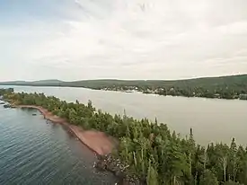 Aerial view of Copper Harbor | |
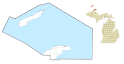 Location within Keweenaw County | |
 Copper Harbor Location within the state of Michigan | |
| Coordinates: 47°28′08″N 87°53′18″W | |
| Country | United States |
| State | Michigan |
| County | Keweenaw |
| Township | Grant |
| Area | |
| • Total | 2.427 sq mi (6.29 km2) |
| • Land | 1.513 sq mi (3.92 km2) |
| • Water | 0.914 sq mi (2.37 km2) |
| Elevation | 605 ft (184 m) |
| Population | |
| • Total | 108 |
| • Density | 71.5/sq mi (27.6/km2) |
| Time zone | UTC−5 (Eastern (EST)) |
| • Summer (DST) | UTC−4 (EDT) |
| ZIP code(s) | 49918 |
| Area code(s) | 906 |
| FIPS code | 26-18100[2] |
| GNIS feature ID | 623809[3] |
| Website | Copper Harbor |
History
Located at the very tip of the Keweenaw peninsula, the Copper Country was initially home to the Ojibwe people, who had lived in the area for thousands of years before the Europeans came to North America. In the year of 1836, the Upper Peninsula was officially ceded from the Native American Chippewa to the United States following the signing of the Treaty of Washington. The treaty was signed in the national capital, Washington, D.C., by Henry Schoolcraft, and Native American representatives from the Ojibwe and Odawa nations.[8]
Copper Harbor was host to the first mineral land agency throughout the entire Lake Superior District. Captain Walter Cunningham was appointed by the now-defunct United States Department of War to act as a Special Agent to the area. As soon as wayfinding was established in the Spring of 1843, Cunningham had came to the area and opened his office which was thereafter named the "Government House." It was positioned on Porter's Island, a small rocky island just opposite of present-day Downtown Copper Harbor.[6]
The Pittsburgh and Boston Copper Harbor Mining Company, formed by John Hayes of Cleveland, Ohio, began excavating some pits near Haye's Point in Copper Harbor in the year of 1844. It was a small development at first, but its mine was modern for its time, and the company struck it rich in 1845. The Pittsburgh and Boston mine operations were some of the very first in the state of Michigan.[6][9][10][11]
A few years later, the Central Mine, Cliff Mine and others were opened and became successful.[12][11][13][6][9]
By 1870, the copper resources in the community had been largely worked out.[10][6]
The community of Copper Harbor was listed as a newly-organized census-designated place for the 2010 census, meaning it now has officially defined boundaries and population statistics for the first time.[14]
Etymology
The name of the community, Copper Harbor, alludes to the former use of its harbor as a port for shipping copper mined from local deposits during the mid-19th century.[15]
Transportation
The town is the northern terminus of US 41 (both in Michigan and nationally) and the eastern terminus of M-26. Both approaches to Copper Harbor, the shore-hugging M-26 from Eagle Harbor and the more inland, rugged US 41 complete with rolling hills, offer dramatic views, as does the Brockway Mountain Drive overlook.[16] During summer months a passenger ferry located at Waterfront Landing provides access to Isle Royale National Park.
Geography
Copper Harbor is at 47°28′08″N 87°53′18″W;[17] this puts it farther north than anywhere else in the state of Michigan, other than Isle Royale National Park. The ZIP code is 49918 and the FIPS place code is 18100. The community sits at the top of the Keweenaw Peninsula, but not at its end. The Peninsula's actual end is roughly 10 miles beyond the town as it curves to the east and south. There is a total of 60 square miles east and south of Copper Harbor with no pavement, development, or attractions.[16][18]
In relation to other communities in the Keweenaw, Copper Harbor is located 9 miles from the now-ghost town of Mandan, 12 miles north of Delaware, 16 miles east of Eagle Harbor, and 37 miles north of the village of Calumet.[6][19][20][21][9]
Climate
Copper Harbor has a humid continental climate.[22] Summers are warm but rarely hot due to the moderating influence of Lake Superior, while winters are cold and snowy, albeit milder than areas on similar parallels to the west, due to the low-scale maritime moderation. Although winter temperatures are similar to those in the nearest large metropolitan city Minneapolis, a couple of degrees latitude south-west, the main difference is that April is also a winter month in Copper Harbor, since the marine effects delay spring. The temperature lag effect is so great that March holds the town's record low, and April's record low temperatures are not much warmer than those of December.
Notable attractions
- Hunter's Point is the name of a non-hilly point, running out from the west into Lake Superior. It was named for an early settler of the area named Mr. Hunter who owned a tract of land on what is now Hunter's Point. He is buried in the Fort Wilkins Cemetery. Today Hunter's Island is a Grant Township park, hosting a wide variety of both flora and fauna alike. It is also a well-known stop for migratory birds.[23][6]
- Just outside the town is the sign marking the End of U.S. Highway 41, which begins in Copper Harbor and ends in the city of Miami, Florida, nearly 2,000 miles away.[24][6][25]
- Just north of Downtown Copper Harbor is the Fort Wilkins Historic State Park, an early restored frontier United States Army base originally built in 1844 to protect the vital port of Copper Harbor from the Ojibwe during the early years of the copper mining boom, America's first great mining rush. It became clear later that issues in the region were their own—rough and icy winters, isolation, and sheer loneliness.[6][5][9][18][26][27]
- The Copper Harbor Schoolhouse, one of the oldest one-room schools in Michigan, is found here. In 1999, this 140-year-old school had nine students who attended classes. The school district it lies in is called Grant Township Schools, District No. 2. The District motto is "Searching For Knowledge" and the mascot of the schoolhouse is the Copper Harbor Prospectors.[28][9][29]
- Copper Harbor is home to a Fourth of July fireworks show that is locally notable on the Keweenaw Peninsula.[16][30]
- Lake Fanny Hooe, named after the mining Captain William Albutrtis' juvenile sister-in-law, borders Fort Wilkins and is well-known in the area for the origin that surrounds its name. This lake is one mile east of Copper Harbor, and runs parallel with the highway M-26. The lake is two miles long and a quarter mile wide, with a total depth of thirty-five feet and numerous points.[9][6][31][32]
- The historic Copper Harbor Lighthouse is situated at the opening of the physical harbor itself. The lighthouse was rebuilt in 1866, replacing an original light from 1849, and is only accessible via a short ride in a compact, open vessel from the Copper Harbor Marina. Taken out of service in 1933, the historic navigational aid is one of the oldest lighthouses on Lake Superior. Within the yellow-bricked maritime post, furnishings from the era remain to conceptualise the life of the lighthouse keepers. Exhibits in the lighthouse museum cover both the lighthouse's history and the local shipwreck culture of the area.[26][33][6][9][27]
- The historic Copper Harbor Cemetery discloses the gravestones of some of the earliest settlers in the Copper Country, with the first recorded interment in 1853 and a number of other tombstones that predate the year 1900.[34][9]
- Characterized as "the most beautiful road in Michigan," Brockway Mountain Drive is a 8.883 mile route that follows the spine of a 735-foot-high ridge between the communities of Copper Harbor and Eagle Harbor, and is the highest-paved road between the Rocky Mountains to the west and the Allegheny Mountains in the east. The notoriously-picturesque road was constructed during the 1930s in the midst of the Great Depression by the Works Progress Administration. It offers views of Lake Superior, and the Keweenaw Peninsula, as well the archipelago of Isle Royale on an especially clear, transparent day. There is also a close on the drive called Brockway Mountain Lookout that offers a view of the community of Copper Harbor itself.[35][16][6][9][18][27]
- In addition to the main 1849 Copper Harbor Lighthouse, the Copper Harbor Front Range and Rear Range Lights, both completed in 1869, still remain and are locally considered to be iconic, as well as being the subject of memorabilia. The purpose of the Copper Harbor Range Lights was to do what the main lighthouse could not; it guided vessels and their sailors past the hazardous reefs on either side of the waterway.[36][20]
| Climate data for Copper Harbor, Michigan (1981–2010 normals, extremes 1972–present) | |||||||||||||
|---|---|---|---|---|---|---|---|---|---|---|---|---|---|
| Month | Jan | Feb | Mar | Apr | May | Jun | Jul | Aug | Sep | Oct | Nov | Dec | Year |
| Record high °F (°C) | 46 (8) |
55 (13) |
70 (21) |
83 (28) |
89 (32) |
94 (34) |
99 (37) |
94 (34) |
95 (35) |
81 (27) |
67 (19) |
56 (13) |
99 (37) |
| Average high °F (°C) | 23.1 (−4.9) |
24.9 (−3.9) |
34.7 (1.5) |
46.0 (7.8) |
58.9 (14.9) |
67.5 (19.7) |
74.0 (23.3) |
75.0 (23.9) |
66.0 (18.9) |
52.3 (11.3) |
39.1 (3.9) |
27.8 (−2.3) |
49.1 (9.5) |
| Average low °F (°C) | 9.8 (−12.3) |
10.1 (−12.2) |
18.2 (−7.7) |
29.8 (−1.2) |
39.4 (4.1) |
47.0 (8.3) |
54.9 (12.7) |
56.9 (13.8) |
50.5 (10.3) |
39.1 (3.9) |
28.0 (−2.2) |
17.1 (−8.3) |
33.4 (0.8) |
| Record low °F (°C) | −18 (−28) |
−22 (−30) |
−23 (−31) |
−2 (−19) |
22 (−6) |
32 (0) |
42 (6) |
44 (7) |
30 (−1) |
21 (−6) |
6 (−14) |
−8 (−22) |
−23 (−31) |
| Average precipitation inches (mm) | 2.65 (67) |
1.44 (37) |
1.71 (43) |
2.18 (55) |
3.11 (79) |
2.69 (68) |
2.18 (55) |
2.63 (67) |
2.96 (75) |
3.28 (83) |
2.83 (72) |
2.33 (59) |
29.99 (760) |
| Average snowfall inches (cm) | 42.9 (109) |
22.5 (57) |
13.1 (33) |
6.6 (17) |
0.5 (1.3) |
— | 0 (0) |
0 (0) |
0 (0) |
0.3 (0.76) |
9.9 (25) |
28.9 (73) |
124.7 (317) |
| Average precipitation days (≥ 0.01 in) | 15.9 | 11.5 | 8.0 | 7.8 | 10.0 | 8.7 | 8.7 | 7.4 | 10.3 | 11.9 | 10.7 | 12.9 | 123.8 |
| Average snowy days (≥ 0.1 in) | 18.1 | 12.3 | 6.8 | 3.1 | 0.2 | 0 | 0 | 0 | 0 | 0.5 | 5.9 | 12.5 | 59.4 |
| Source: NOAA[37] | |||||||||||||
Gallery
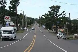 Looking west in Downtown Copper Harbor
 The sign for Copper Harbor on US 41
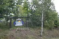 a Welcome sign to the community
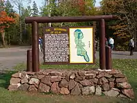 A sign, marking the northern terminus of US Highway 41, just east of Copper Harbor.
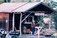 A Finnish-themed gift shop in Copper Harbor.
References
- "2010 Census Gazetteer Files - Places: Michigan". U.S. Census Bureau. Retrieved August 1, 2017.
- "U.S. Census website". United States Census Bureau. Retrieved 2008-01-31.
- U.S. Geological Survey Geographic Names Information System: Copper Harbor, Michigan
- "Copper Harbor, Keweenaw Co., Michigan, USA". www.mindat.org. Retrieved 2019-05-22.
- Hintz, Martin (1998). America The Beautiful: Michigan. Danbury, Connecticut: Children's Press. ISBN 0-516-20636-2.
- Monette, Clarence J. (1975). Some Copper Country Names And Places. Lake Linden, Michigan. ISBN 0-942363-04-3.
- hostmaster (2016-11-16). "Copper Harbor". Michigan. Retrieved 2019-05-15.
- Magnaghi, Russell M. (2009). Native Americans of Michigan's Upper Peninsula: A Chronology to 1900 (2nd ed.). Marquette, Michigan: Center for Upper Peninsula Studies. ISBN 978-0-557-33460-5.
- Molloy, Lawrence J. (2011). A Guide to Michigan's Historic Keweenaw Copper District: Photographs, Maps, and Tours of the Keweenaw—Past and Present. ISBN 978-0-9791772-1-7.
- Dunbar, Willis Frederick, & May, George S. (1995). Michigan: A History of the Wolverine State, p. 358. Grand Rapids: Wm. B. Eerdmans Publishing Co.
- Whittlesey, Charles (1852). 4000 Years of Copper Country History. Greenlee Printing Co.
- "Copper Mining History and Copper Harbor Michigan". www.exploringthenorth.com. Retrieved 2019-05-15.
- Mansfield, John Brandt (1899). History of the Great Lakes, p. 199. J. H. Beers & Co.
- "Michigan: 2010 Population and Housing Unit Counts 2010 Census of Population and Housing" (PDF). 2010 United States Census. United States Census Bureau. September 2012. p. III-6. Retrieved August 8, 2016.
- Lankton, Larry (2010). Hollowed Ground. Wayne State University Press. pp. 13–14. ISBN 9780814334904.
- Vachon, Paul (2015). Michigan's Upper Peninsula. Berkeley, California: Avalon Travel. ISBN 978-1-61238-986-8.
- U.S. Geological Survey Geographic Names Information System: Copper Harbor, Michigan. Retrieved 2008-05-01.
- Penrod, John (2001). Michigan's Copper Country: Michigan's Historic Wilderness. Berrien Center, MI. ISBN 0-942618-69-6.
- "Seeing The Light - Eagle Harbor Range Lights". www.terrypepper.com. Retrieved 2019-05-22.
- "Copper Harbor Rear Range (Michigan) - 1910". uslhs.org. Retrieved 2019-05-22.
- White, Mel (2016). National Geographic Complete National Parks of the United States (Second ed.). Washington, D.C.: National Geographic Partners. ISBN 978-1-4262-1692-3.
- "Copper Harbor, Michigan Climate Summary". Weatherbase. Retrieved 10 November 2015.
- "Hunter's Point Park - Grant Township". 2016-04-22. Archived from the original on 2016-04-22. Retrieved 2019-05-22.
- "End of US highway 41". US Ends .com. Retrieved 2019-05-15.
- "Beginning of U.S. 41 at Copper Harbor, Autumn Scenic Drive". TakeMyTrip.com. 2018-05-13. Retrieved 2019-05-21.
- National Geographic Guide to State Parks of the United States (Fifth ed.). Washington, D.C.: National Geographic Partners. 2018. ISBN 978-1-4262-1885-9.
- National Geographic Guide to Scenic Highways & Byways: The 300 Best Drives in the U.S. Washington, D.C. ISBN 978-1-4262-1905-4.
- "schoolcopperharbor". schoolcopperharbor. Retrieved 2019-05-20.
- "Copper Country Intermediate School District". Hancock, Michigan. Retrieved 20 May 2019.
- "Annual Festivals Keweenaw Michigan". Keweenaw Convention & Visitor’s Bureau. Retrieved 2019-05-20.
- "Lake Fanny Hooe Resort & Campground. Located at Keweenaw's Copper Harbor, in Michigan's Upper Peninsula". www.fannyhooe.com. Retrieved 2019-05-22.
- "Lake Fanny Hooe". Keweenaw Convention & Visitor’s Bureau. Retrieved 2019-05-22.
- James, Barry C. (2000). Lighting the Way: A History Of The Copper Harbor Lighthouse. Copper Harbor, Michigan: Fort Wilkins Natural History Association. ISBN 0-9675103-0-9.
- "MI State Historic Preservation Objects". 2012-06-12. Archived from the original on 2012-06-12. Retrieved 2019-05-22.
- Howard, Philip J. (2014). Yankee Yooper On The Keweenaw. ISBN 978-1-4931-8789-8. LCCN 2014905453.
- "Michigan / Copper Harbor Old Rear Range light - plate (mitko)". World of Lighthouses. Retrieved 2019-05-22.
- "NOWData - NOAA Online Weather Data". National Oceanic and Atmospheric Administration. Retrieved 2012-04-14.
External links
| Wikimedia Commons has media related to Copper Harbor, Michigan. |
- Official community of Copper Harbor website
- Copper Country Explorer
- Copper Harbor biking and hiking trails
Municipalities and communities of Keweenaw County, Michigan, United States | ||
|---|---|---|
| Village | 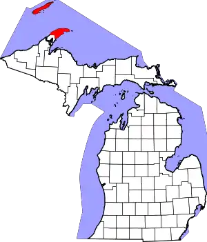 Map of Michigan highlighting Keweenaw County.svg | |
| Civil townships | ||
| CDPs | ||
| Unincorporated communities | ||
| Ghost towns | ||
| ||