Keweenaw County, Michigan
Keweenaw County (/kiwənɔː/ KEY-wuh-naw) is a county in the Upper Peninsula of the U.S. state of Michigan, the state's northernmost county. As of the 2010 United States Census, the population was 2,156, making it Michigan's least populous county.[3] It is also the state's largest county by total area, when the waters of Lake Superior are included in the total. The county seat is Eagle River.[4]
Keweenaw County | |
|---|---|
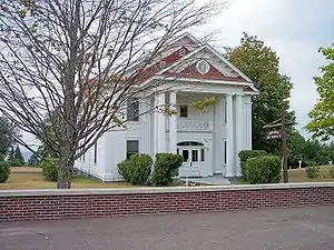 Keweenaw County Courthouse (built 1866) in Eagle River | |
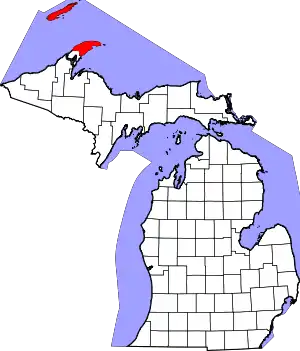 Location within the U.S. state of Michigan | |
 Michigan's location within the U.S. | |
| Coordinates: 47°29′N 88°10′W | |
| Country | |
| State | |
| Founded | March 11, 1861[1][2] |
| Named for | Keweenaw Bay |
| Seat | Eagle River |
| Largest community | Ahmeek |
| Area | |
| • Total | 5,966 sq mi (15,450 km2) |
| • Land | 540 sq mi (1,400 km2) |
| • Water | 5,426 sq mi (14,050 km2) 91%% |
| Population | |
| • Estimate (2018) | 2,113 |
| • Density | 4.0/sq mi (1.5/km2) |
| Time zone | UTC−5 (Eastern) |
| • Summer (DST) | UTC−4 (EDT) |
| Congressional district | 1st |
| Website | www |
The county was set off and organized in 1861.[1] It is believed "Keweenaw" is a Native American word that means "portage or place where portage is made".[1] Keweenaw County is part of the Houghton, Michigan, Micropolitan Statistical Area. Isle Royale, a national park which no longer has year-round inhabitants, was a separate county that was incorporated into Keweenaw County in 1897.
Geography
Two land masses comprise most of the land portion of the county: Isle Royale and the northeastern half of the Keweenaw Peninsula. The county also includes the waters of Lake Superior between the two, extending to the state's water borders with Ontario and Minnesota. It is thus the largest county in Michigan by total area, at 5,966 square miles (15,450 km2), of which 540 square miles (1,400 km2) is land and 5,426 square miles (14,050 km2) (91%) is water.[5] Of all counties (or equivalents) in the United States, Keweenaw County has the highest proportion of water area to total area.
The largest lake entirely within the county is Gratiot Lake at 1,438 acres (5.82 km2), located at the base of the county's two highest peaks: Mt. Horace Greeley at 1,550 feet (470 m) and Mt. Gratiot at 1,490 feet (450 m).[6] Other lakes include Lac La Belle near Bete Grise Bay, Lake Medora, Lake Fanny Hooe near Copper Harbor, Lake Bailey at the base of Mt. Lookout, and Schlatter Lake at the tip of the peninsula.
National protected area
Major highways
 US 41 runs northeast–southwest through the upper center part of the mainland portion of the county. It enters the southern area of the county at Bumbletown passes Phoenix, Delaware, Mandan, Copper Harbor and terminates north of Lake Fanny Hooe.
 M-26 loops from Phoenix to the shoreline of Lake Superior, then runs northeasterly along the shoreline to the intersection with US 41 at Copper Harbor.[7]
Adjacent counties and district
- Alger County, Michigan, east
- Cook County, Minnesota, northwest/CT border
- Houghton County, Michigan, south (only land border)
- Marquette County, Michigan, southeast
- Ontonagon County, Michigan, southwest
- Thunder Bay District, Ontario, north
Demographics
The 2010 United States Census[8] indicates Keweenaw County had a population of 2,156. This decrease of 145 people from the 2000 United States Census represents a -6.3% change in population. In 2010 there were 1013 households and 614 families in the county. The population density was 4 people per square mile (2/km2). There were 2,467 housing units at an average density of 4 per square mile (2/km2). 98.5% of the population were White, 0.1% Black or African American, 0.1% Native American and 1.2% of two or more races. 0.7% were Hispanic or Latino (of any race). 38.8% were of Finnish, 14.0% German, 9.0% English, 6.6% French, French Canadian or Cajun and 5.7% Irish ancestry.[9]
There were 1013 households, out of which 16.8% had children under the age of 18 living with them, 52.4% were married couples living together, 4.9% had a female householder with no husband present, and 39.4% were non-families. 34.2% of all households were made up of individuals, and 15.0% had someone living alone who was 65 years of age or older. The average household size was 2.12 and the average family size was 2.71.
The county population contained 17.9% under the age of 18, 5.2% from 18 to 24, 20.0% from 25 to 44, 36.0% from 45 to 64, and 24.1% who were 65 years of age or older. The median age was 51.6 years. The population is 51.3% male and 48.7% female.
The median income for a household in the county was $39,821, and the median income for a family was $48,563. The per capita income for the county was $21,218. About 16.6% of families and 17.8% of the population were below the poverty line, including 34.2% of those under age 18 and 4.0% of those age 65 or over.
Politics
Keweenaw County was solidly Republican after the American Civil War, and until the Franklin Delano Roosevelt era. In 1900,[10] 1904[11] and 1908[12] it stood as the nation's most Republican county. In his last election of 1944, Roosevelt became the first Democrat to win the county since Horatio Seymour in 1868.[13] However, from 1964 to 1996 Keweenaw voted Democratic in every election except 1972 and 1980, thus standing as one of only six counties nationwide[lower-alpha 1] to support both Alf Landon and Walter Mondale, who suffered the two worst electoral vote losses since 1824. Since 2000, the county has become solidly Republican again.
| Year | Republican | Democratic | Third Parties |
|---|---|---|---|
| 2020 | 55.4% 862 | 43.2% 672 | 1.5% 23 |
| 2016 | 56.8% 814 | 36.8% 527 | 6.5% 93 |
| 2012 | 55.6% 774 | 41.8% 582 | 2.6% 36 |
| 2008 | 53.6% 756 | 43.3% 610 | 3.1% 44 |
| 2004 | 54.3% 781 | 43.8% 630 | 2.0% 28 |
| 2000 | 55.1% 740 | 40.2% 540 | 4.7% 63 |
| 1996 | 39.5% 491 | 46.1% 572 | 14.4% 179 |
| 1992 | 32.2% 378 | 49.6% 582 | 18.2% 213 |
| 1988 | 45.8% 536 | 53.9% 631 | 0.3% 3 |
| 1984 | 48.8% 599 | 51.2% 628 | 0.0% 0 |
| 1980 | 46.3% 583 | 45.2% 570 | 8.5% 107 |
| 1976 | 47.7% 606 | 51.8% 658 | 0.6% 7 |
| 1972 | 60.5% 715 | 38.6% 456 | 0.9% 11 |
| 1968 | 44.0% 525 | 50.4% 602 | 5.6% 67 |
| 1964 | 30.3% 374 | 69.6% 860 | 0.1% 1 |
| 1960 | 50.9% 684 | 48.8% 655 | 0.3% 4 |
| 1956 | 54.8% 834 | 45.2% 689 | 0.0% 0 |
| 1952 | 51.4% 801 | 47.9% 747 | 0.7% 11 |
| 1948 | 50.1% 814 | 39.8% 647 | 10.1% 164 |
| 1944 | 47.1% 866 | 52.5% 965 | 0.3% 6 |
| 1940 | 52.4% 1,080 | 46.9% 967 | 0.6% 13 |
| 1936 | 49.7% 1,070 | 49.2% 1,060 | 1.1% 24 |
| 1932 | 72.5% 1,454 | 26.3% 527 | 1.3% 26 |
| 1928 | 76.6% 1,305 | 21.1% 360 | 2.3% 39 |
| 1924 | 91.2% 1,421 | 3.2% 50 | 5.7% 88 |
| 1920 | 90.2% 1,272 | 6.3% 89 | 3.5% 50 |
| 1916 | 78.0% 860 | 17.6% 194 | 4.4% 49 |
| 1912 | 44.8% 495 | 5.3% 59 | 49.9% 551 |
| 1908 | 90.6% 1,026 | 5.6% 63 | 3.9% 44 |
| 1904 | 94.6% 659 | 4.2% 29 | 1.3% 9 |
| 1900 | 92.2% 452 | 6.3% 31 | 1.4% 7 |
| 1896 | 89.0% 411 | 9.7% 45 | 1.3% 6 |
| 1892 | 65.4% 400 | 33.0% 202 | 1.6% 10 |
| 1888 | 68.5% 411 | 30.8% 185 | 0.7% 4 |
| 1884 | 74.4% 620 | 24.1% 201 | 1.4% 12 |
Government


The county government operates the jail, maintains rural roads, operates the major local courts, records deeds, mortgages, and vital records, administers public health regulations, and participates with the state in the provision of social services. The county board of commissioners controls the budget and has limited authority to make laws or ordinances. In Michigan, most local government functions—police and fire, building and zoning, tax assessment, street maintenance, etc.—are the responsibility of individual cities and townships.
| Historical population | |||
|---|---|---|---|
| Census | Pop. | %± | |
| 1870 | 4,205 | — | |
| 1880 | 4,270 | 1.5% | |
| 1890 | 2,894 | −32.2% | |
| 1900 | 3,217 | 11.2% | |
| 1910 | 7,156 | 122.4% | |
| 1920 | 6,322 | −11.7% | |
| 1930 | 5,076 | −19.7% | |
| 1940 | 4,004 | −21.1% | |
| 1950 | 2,918 | −27.1% | |
| 1960 | 2,417 | −17.2% | |
| 1970 | 2,264 | −6.3% | |
| 1980 | 1,963 | −13.3% | |
| 1990 | 1,701 | −13.3% | |
| 2000 | 2,301 | 35.3% | |
| 2010 | 2,156 | −6.3% | |
| 2018 (est.) | 2,113 | [16] | −2.0% |
| US Decennial Census[17] 1790-1960[18] 1900-1990[19] 1990-2000[20] 2010-2018[3] | |||
The Keweenaw County Courthouse and Sheriff's Residence and Jail in Eagle River faces Lake Superior. The courthouse was built in 1866, followed by the sheriff's residence and jail in 1886, and then remodeled in 1925. In her book Buildings of Michigan, Eckert writes:
- “Like a meetinghouse on a New England public square, and enclosed by a 3-foot [0.91 m] high public wall on the east and south sides, ...transformed in 1925 into its present stark white classical appearance. The courthouse for this sparsely populated remote county is remarkable in its formality...These include the giant Doric columns with fillets and bases, a pediment forming a projecting portico, a modillioned cornice, and pedimented side dormers.” (p. 481)
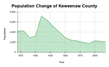 The graph depicts the change in population of the county over its history. The record starts at 1870, and goes until 2018.
The courthouse still preserves its original appearance.
Sparsely-populated Keweenaw County was a mining center in the latter 19th century but in the 20th century turned into a resort community. Because of this trend, Keweenaw County is also the only county in Michigan to have a lower population in the year 2000 than in 1900.
Elected officials
- Probate Judge: Keith DeForge
- Prosecuting Attorney: Charles (Chuck) Miller
- Sheriff: Curt Pennala
- County Clerk/Register of Deeds: Julie Carlson
- County Treasurer: Eric Hermanson
- Mine Inspector: John Cima
(information as of January 2021)[21]
Communities
Village
Civil townships
Census-designated places
- Copper Harbor
- Eagle Harbor
- Eagle River (county seat)
Other unincorporated communities
- Ahmeek Location
- Allouez
- Bete Grise
- Bumbletown
- Central (ghost town)
- Eagle Nest
- Fulton
- Gay
- Hebards (also called Hebard)
- Lac La Belle
- Mandan
- Mohawk
- New Allouez
- Phoenix
- Snowshoe
- Traverse[7]
See also
Notes
- The other five are the Massachusetts counties of Middlesex and Dukes, college town Tompkins County, New York, historically heavily unionized coal mining Magoffin County, Kentucky, and Ringgold County, Iowa.
References
- Clarke Historical Library. "Bibliography on Keweenaw County". Central Michigan University. Archived from the original on October 20, 2013. Retrieved June 29, 2013.
- "This date in Michigan History: March 11, 1861". Michigan History. Archived from the original on January 5, 2009. Retrieved June 14, 2006.
- United States Census Bureau. "State & County QuickFacts". United States Census Bureau. Archived from the original on June 6, 2011. Retrieved August 28, 2013.
- National Association of Counties. "Find a County". National Association of Counties. Archived from the original on May 31, 2011. Retrieved June 7, 2011.
- United States Census Bureau (August 22, 2012). "2010 Census Gazetteer Files". United States Census Bureau. Archived from the original on November 13, 2013. Retrieved September 26, 2014.
- Rozich, Tom (December 28, 2012). "Gratiot Lake: a jewel of the Keweenaw Peninsula/Biological Bits". The Daily Mining Gazette. Houghton MI. Archived from the original on January 17, 2013. Retrieved April 20, 2013.
- Google (October 9, 2018). "Keweenaw County MI" (Map). Google Maps. Google. Retrieved October 9, 2018.
- United States Census Bureau. "U.S. Census website". Retrieved June 5, 2013.
- Data Access and Dissemination Systems (DADS). "U.S. Census website". United States Census Bureau. Retrieved June 5, 2013.
- Leip, Dave (2016). "1900 Presidential Election Statistics". Atlas of US Presidential Elections. Archived from the original on August 23, 2017. Retrieved February 14, 2017.
- Leip, Dave (2016). "1904 Presidential Election Statistics". Atlas of US Presidential Elections. Archived from the original on February 14, 2017. Retrieved February 14, 2017.
- Leip, Dave (2016). "1908Presidential Election Statistics". Atlas of US Presidential Elections. Archived from the original on February 2, 2017. Retrieved February 14, 2017.
- Menendez, Albert J. (2005). The Geography of Presidential Elections in the United States, 1868–2004. Jefferson NC: McFarland. pp. 223–225.
- "US Election Atlas". Archived from the original on March 23, 2018. Retrieved February 14, 2017.
- "Copper Mining History and Copper Harbor Michigan". exploringthenorth.com. Archived from the original on October 15, 2011. Retrieved April 9, 2010.
- "Population and Housing Unit Estimates". Retrieved May 9, 2019.
- United States Census Bureau. "US Decennial Census". United States Census Bureau. Retrieved September 26, 2014.
- University of Virginia Library. "Historical Census Browser". University of Virginia Library. Archived from the original on August 11, 2012. Retrieved September 26, 2014.
- United States Census Bureau. "Population of Counties by Decennial Census: 1900 to 1990". United States Census Bureau. Archived from the original on February 15, 2015. Retrieved September 26, 2014.
- United States Census Bureau. "Census 2000 PHC-T-4. Ranking Tables for Counties: 1990 and 2000" (PDF). United States Census Bureau. Archived (PDF) from the original on December 18, 2014. Retrieved September 26, 2014.
- "Keweenaw County Website". Archived from the original on January 7, 2021. Retrieved January 7, 2021.
Further reading
- Thurner, Arthur W. (1994). Strangers and Sojourners: A History of Michigan's Keweenaw Peninsula. Detroit: Wayne State University Press. ISBN 0-8143-2396-0.
External links
| Wikimedia Commons has media related to Keweenaw County, Michigan. |
- Keweenaw Convention & Visitors Bureau
- Keweenaw Liberty Library
- Keweenaw County Profile, Sam M Cohodas Regional Economist
- CopperCountry.com Tourism and Events Information for Keweenaw, Houghton and Ontonagon Counties.
- CopperCountryExplorer.com
- Keweenaw County Chamber of Commerce
- "Bibliography on Keweenaw County". Clarke Historical Library, Central Michigan University.
- Hunt's Guide to the Keweenaw Peninsula
- Western Upper Peninsula Planning & Development Region
Places adjacent to Keweenaw County, Michigan | ||||||||||
|---|---|---|---|---|---|---|---|---|---|---|
| ||||||||||
Municipalities and communities of Keweenaw County, Michigan, United States | ||
|---|---|---|
| Village | Map of Michigan highlighting Keweenaw County.svg | |
| Civil townships | ||
| CDPs | ||
| Unincorporated communities | ||
| Ghost towns | ||
| ||
| Central cities | |
|---|---|
| Counties | |
| Geography | |
| Transportation | |
| Economy | |
| Authority control |
|---|