Cowra
Cowra is a small town in the Central West region of New South Wales, Australia. It is the largest population centre and the council seat for the Cowra Shire, with a population of 9,863.[1]
| Cowra New South Wales | |||||||||
|---|---|---|---|---|---|---|---|---|---|
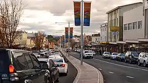  .jpg.webp) 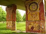 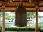 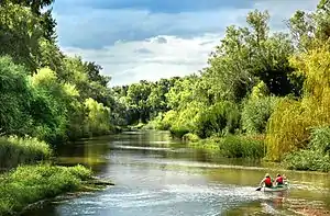 From top to bottom, left to right: Kendal Street divides the CBD; the Eastern entrance to the town, near Europa Park; Crops of canola creating fields of gold; the pylons of the Cowra Bridge decorated in Aboriginal art, Australia's World Peace Bell proudly housed in Cowra's Civic Square; and the Lachlan River which flows through the heart of the town | |||||||||
Cowra | |||||||||
| Coordinates | 33°50′02″S 148°41′10″E | ||||||||
| Population | 9,863 (2016 census)[1] | ||||||||
| Established | 1846 | ||||||||
| Gazetted | 1849 | ||||||||
| Postcode(s) | 2794 | ||||||||
| Elevation | 310 m (1,017 ft) | ||||||||
| Time zone | AEST (UTC+10) | ||||||||
| • Summer (DST) | AEDT (UTC+11) | ||||||||
| Location | |||||||||
| LGA(s) | Cowra Shire | ||||||||
| County | Forbes, Bathurst | ||||||||
| State electorate(s) | Cootamundra | ||||||||
| Federal Division(s) | Riverina | ||||||||
| |||||||||
Cowra is located approximately 310 m (1,017 ft) above sea level, on the banks of the Lachlan River, in the Lachlan Valley. By road it is approximately 310 km (193 mi) south-west of the state capital, Sydney, and 189 km (117 mi) north of the nation's capital, Canberra.[6] The town is situated at the intersection of three state highways: the Mid-Western Highway, Olympic Highway, and the Lachlan Valley Way.
Cowra is included in the rainfall recorder and weather forecast region for the Central West Slopes and Plains division of the Bureau of Meteorology forecasts.[7]
History
The first European explorer to the area, George William Evans, entered the Lachlan Valley in 1815. He named the area the Oxley Plains after his superior the surveyor-general, John Oxley. In 1817 he deemed the area "rather unfit for settlement". A military depot was established not long after at Soldiers Flat near present-day Billimari. Arthur Ranken and James Sloan, from Bathurst, were amongst the first white settlers on the Lachlan. They moved to the area in 1831.
The township of "Coura Rocks" had its beginnings in 1844. Around 1847, the township site became known as Cowra, and in 1849, was proclaimed a village.[8]
In the 1850s many gold prospectors passed through headed for gold fields at Lambing Flat (Young) and Grenfell. The first school was established in 1857. The first bridge over the Lachlan River was built in 1870. Gold was discovered at Mount McDonald in the 1880s. The rail head, from Sydney, reached Cowra in 1886. Local government was granted in 1888. The first mobile telephone exchange was established in 1901. The town water supply was established in 1909, the gasworks in 1912 and town supplied electricity was introduced in 1924.
Cowra hosts an annual Festival of International Understanding, featuring a parade, a fireworks display, balloons for the kids and events showcasing a particular foreign culture. In 2020 it was cancelled due to the COVID-19 pandemic.[9]
Cowra prisoner of war camp
During World War II, Cowra was the site of a prisoner of war (POW) camp. Most of the detainees were captured Japanese and Italian military personnel. However, in July 1942, Indonesian political prisoners from the Dutch Tanahmerah prison on the Digul river, in West Papua, were transported as "prisoners-of-war" to the Cowra prison camp, at the behest of Netherlands East Indies government in exile (with others who were ill being sent to Liverpool).[10] These Indonesian prisoners arrived in mid 1942 and were released on 7 December 1943, and subsequent to their release, played an important role in the black bans which effectively frustrated the Dutch reimposition of colonial rule in the Indies.)[10]
The Cowra breakout
On 5 August 1944, at least 545 Japanese POWs attempted a mass breakout from the camp. Simultaneously, other Japanese prisoners committed suicide, or were killed by their countrymen, inside the camp.
The actions of the POWs in storming machine gun posts, armed only with improvised weapons, showed what Prime Minister John Curtin described as a "suicidal disregard of life".
During the breakout and subsequent recapture of POWs, four Australian guards and 231 Japanese died, and 108 prisoners were wounded. The dead Japanese were buried in Cowra in the specially created Japanese War Cemetery. This is the only such cemetery in Australia, and also holds some of the dead from the World War II air raids on Darwin.
An Avenue of Honour also commemorates those who died in World War I. There is an annual ceremony to commemorate the breakout, involving local school students, council members, local dignitaries and guest Japanese visitors.
Heritage listings
Cowra has a number of heritage-listed sites, including:
- Blayney-Harden railway: Lachlan River railway bridge, Cowra[11]
- Blayney-Harden railway: Cowra railway station[12]
- Evans Street: Cowra Prisoner of War Camp Site[13]
Population
According to the 2016 census of Population, there were 10,063 people in Cowra.
- Italian people made up 5% of the population.
- 85.2% of people were born in Australia. The next most common country of birth was England at 1.4%.
- 89.0% of people spoke only English at home.
- The most common responses for religion were Catholic 29.7%, Anglican 26.0% and No Religion 16.0%.[1]
Climate
Cowra has a temperate climate, with average maximum temperatures ranging from 32 °C (90 °F) in summer to 14 °C (57 °F) in winter, while minimums range from 16 °C (61 °F) to 2 °C (36 °F). Under the Köppen climate classification, Cowra has a borderline semi-arid (BSk) and humid subtropical (Cfa) climate.[14]
Cowra sits on the border zone between the cool, wet highlands of the Great Dividing Range and the hot, dry plains of Western New South Wales. As a result, Cowra experiences climate characteristics of both regions, with cold sub-zero temperatures, frequent frost and occasional snow in winter, and frequent 40+ °C temperatures in summer. Other towns that experience this 'border' climate are Gunnedah and Mudgee further north, Yass and Gundagai further south, Wangaratta in Victoria and Dalby in Queensland.
Rainfall is mild and distributed fairly evenly all year round, however it slightly peaks in summer with thunderstorms and again in winter with cold fronts. The average annual rainfall is 598.3 mm (24 in), while Cowra's wettest month on record was January 1984, with 371.0 mm (15 in) recorded. Extreme temperatures have ranged from 46.6 °C (116 °F) to −8.0 °C (18 °F). Cowra has 145.8 clear days on an annual basis.[15]
| Climate data for Cowra Airport (1966–2015) | |||||||||||||
|---|---|---|---|---|---|---|---|---|---|---|---|---|---|
| Month | Jan | Feb | Mar | Apr | May | Jun | Jul | Aug | Sep | Oct | Nov | Dec | Year |
| Record high °C (°F) | 46.6 (115.9) |
44.2 (111.6) |
39.5 (103.1) |
36.0 (96.8) |
27.0 (80.6) |
24.0 (75.2) |
22.0 (71.6) |
34.4 (93.9) |
33.5 (92.3) |
36.7 (98.1) |
43.8 (110.8) |
41.8 (107.2) |
46.6 (115.9) |
| Average high °C (°F) | 31.9 (89.4) |
30.7 (87.3) |
28.1 (82.6) |
23.6 (74.5) |
18.6 (65.5) |
14.7 (58.5) |
13.7 (56.7) |
15.5 (59.9) |
18.6 (65.5) |
22.7 (72.9) |
26.7 (80.1) |
30.2 (86.4) |
23.0 (73.4) |
| Average low °C (°F) | 15.6 (60.1) |
15.6 (60.1) |
12.5 (54.5) |
8.3 (46.9) |
5.1 (41.2) |
3.1 (37.6) |
2.1 (35.8) |
2.8 (37.0) |
4.5 (40.1) |
7.0 (44.6) |
10.2 (50.4) |
13.1 (55.6) |
8.3 (46.9) |
| Record low °C (°F) | 5.0 (41.0) |
5.0 (41.0) |
0.6 (33.1) |
−3.0 (26.6) |
−5.0 (23.0) |
−5.5 (22.1) |
−8.0 (17.6) |
−6.0 (21.2) |
−3.0 (26.6) |
−2.0 (28.4) |
−2.0 (28.4) |
2.0 (35.6) |
−8.0 (17.6) |
| Average rainfall mm (inches) | 59.6 (2.35) |
52.9 (2.08) |
40.4 (1.59) |
42.8 (1.69) |
46.3 (1.82) |
40.5 (1.59) |
52.5 (2.07) |
47.8 (1.88) |
52.5 (2.07) |
56.3 (2.22) |
53.3 (2.10) |
53.4 (2.10) |
598.3 (23.56) |
| Average rainy days (≥ 0.2mm) | 6.5 | 5.7 | 5.8 | 5.5 | 7.6 | 9.4 | 11.0 | 10.2 | 9.1 | 8.2 | 7.8 | 6.5 | 93.3 |
| Average relative humidity (%) | 34 | 37 | 39 | 44 | 54 | 63 | 62 | 57 | 53 | 47 | 39 | 32 | 47 |
| Source: Bureau of Meteorology[15] | |||||||||||||
Education
- Primary schools
- Cowra Public
- Mulyan Public School
- Holman Place Public School
- St Raphael's Catholic School (K–6)
- Secondary schools
- Cowra High School (7–12)
- St Raphael's Catholic School (7–12)
Cowra also has a campus of the Western Institute of TAFE.
Media
Radio stations
Radio stations with transmitters located in or nearby to Cowra include-
AM:
- ABC Local Radio 549 AM
- 2LF 1350 AM
FM:
- Hit Network 105.9 FM
- Triple M - Central West 105.1 FM
- Roccy FM 99.5 FM
- ABC Classic FM 102.7 FM
- ABC Radio National 104.3 FM
- FM107.5 107.5 FM
- Triple J (2JJJ) 101.9 FM
Television
Cowra receives five free-to-air television networks and their affiliates which are relayed from Orange, and broadcast from nearby Mt Canobolas:
- ABC - ABC1, ABC2, ABC3 and ABC News 24
- SBS - SBS ONE and SBS Two, NITV
- Prime7 - Prime7, 7Two, 7mate, 4ME
- WIN - WIN HD, One, Eleven, Gold
- Southern Cross Nine - 9HD, 9Gem, 9Go!, 9Life and Extra
- Local half-hour long news bulletins are broadcast by Prime7, WIN and Nine.
Subscription television service Foxtel is available in Cowra and the surrounding region via satellite transmission.
Print
The local newspaper is the Cowra Guardian, published by Fairfax Media.
Viticulture
Viticulture is a significant industry in the Cowra area. The first vineyards were planted in the 1970s and were predominantly Chardonnay. Since this time, a range of varieties have had success, including Sangiovese, Mourvedre and Tempranillo.[16]
Japanese War Cemetery and Garden
The Japanese War Cemetery holding the dead from the Cowra Breakout was tended by members of the Cowra RSL after World War II. The cemetery is on Crown land owned by the New South Wales government under trusteeship of the Commonwealth War Graves Commission. Use of the land was granted to Japan in 1963 on a payment-of-costs basis.[17][18]
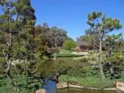
In 1971 the Cowra Tourism Development decided to celebrate this link to Japan, and proposed a Japanese Garden for the town. The Japanese government agreed to support this development as a sign of thanks for the respectful treatment of their war dead; the development also received funding from the Australian government and private entities. The Cowra Japanese Garden and Cultural Centre was designed by Ken Nakajima (1914–2000), a world-renowned designer of Japanese gardens at the time. The first stage was opened in 1979, with a second stage opened in 1986.
The gardens were also designed in the style of the Edo period and are a komatsu ("small pine-tree") or strolling garden. The rocky hillside, manicured hedges, waterfalls and streams, and the two lakes provide a serene environment for a myriad of birdlife. Special features of the Garden include a Bonsho Bell, a traditional Edo Cottage, an authentic open air Tea House and a Bonsai House. They are designed to show all of the landscape types of Japan. At five hectares (12 acres), the Cowra Japanese Garden is the largest Japanese garden in the Southern Hemisphere. An annual Sakura Matsuri (cherry blossom festival) is a major event in Cowra's tourism calendar and is held in the gardens during September. The festival celebrates the birth of spring. It attracts performers from across Australia and around the world. Locals, Australian and international visitors alike have the opportunity to experience traditional elements of Japanese culture. Sakura at the Cowra Japanese Garden is celebrated annually when the cherry blossoms are at their peak.
 Japanese lake with stone lantern
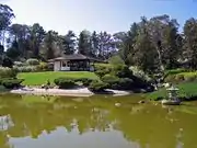 Looking across the lake to the teahouse
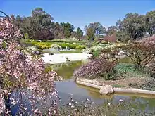 Lower lake with spring blossoms
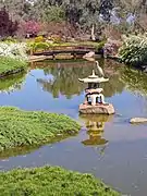 Big bird rests on a stone lantern in the upper lake
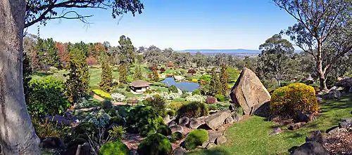 Panoramic view from the Symbolic Mountain at the Japanese Gardens
Sporting clubs
- Cowra Eagles are a rugby union team playing in the Central West Rugby Union competition.
- Cowra Magpies are a rugby league team playing in the Group 10 competition.
- Cowra Blues are an Australian rules football team playing in the Central West AFL competition.
- Cowra Eagles are a soccer club playing in the Orange District Soccer Senior Men's (1st Grade) competition.
- Cowra Netball association play in State Age Championships competition.
References
- Australian Bureau of Statistics (27 June 2017). "Cowra (State Suburb)". 2016 Census QuickStats. Retrieved 1 December 2018.

 Material was copied from this source, which is available under a Creative Commons Attribution 4.0 International License.
 - "Great Circle Distance between ORANGE and COWRA". Geosciences Australia website. Commonwealth of Australia. Archived from the original on 20 October 2012. Retrieved 16 August 2011.
- "Great Circle Distance between BATHURST and COWRA". Geosciences Australia website. Commonwealth of Australia. Archived from the original on 15 June 2013. Retrieved 16 August 2011.
- "Great Circle Distance between CANBERRA and COWRA". Geosciences Australia website. Commonwealth of Australia. Archived from the original on 20 October 2012. Retrieved 16 August 2011.
- "Great Circle Distance between SYDNEY and COWRA". Geosciences Australia website. Commonwealth of Australia. Archived from the original on 20 October 2012. Retrieved 16 August 2011.
- Google Maps @ (34.4464296,147.639039)
- Central West Slopes and Plains Australian Government Bureau of Meteorology
- "Cowra". Travel. The Sydney Morning Herald. 8 February 2004. Retrieved 24 October 2011.
- "Festival of International Understanding". Australian Broadcasting Corporation Central West NSW. 2002. Archived from the original on 15 June 2011. Retrieved 23 November 2010.
- Lockwood, R. (1975) Black Plague. Australasian Book Society Ltd., Sydney, Australia. ISBN 9 09916 68 3
- "Cowra rail bridge over Lachlan River". New South Wales State Heritage Register. Office of Environment and Heritage. H01031. Retrieved 18 May 2018.
- "Cowra Railway Station and yard group". New South Wales State Heritage Register. Office of Environment and Heritage. H01122. Retrieved 18 May 2018.
- "Cowra Prisoner of War Camp Site". New South Wales State Heritage Register. Office of Environment and Heritage. H00619. Retrieved 18 May 2018.
- "Archived copy". Archived from the original on 30 May 2016. Retrieved 26 May 2016.CS1 maint: archived copy as title (link)
- "COWRA AIRPORT COMPARISON". Climate statistics for Australian locations. Bureau of Meteorology. April 2013. Retrieved 26 April 2013.
- "Vineyards of Cowra and Canowindra, NSW Central Ranges". Cowra Region Vineyard Association Inc. Retrieved 29 October 2016.
- Rix, Alan (2013). The Australia-Japan political alignment : 1952 to the present. Routledge. ISBN 978-1134641734.
- "Cowra Japanese War Cemetery and Shrine Area". Register of War Memorials in NSW. Government of New South Wales. 11 April 2012. Retrieved 22 September 2018.
External links
| Wikimedia Commons has media related to Cowra. |
 Cowra travel guide from Wikivoyage
- Cowra Shire Council
- Fact sheet on 1944 Cowra outbreak, National Archives of Australia
- Cowra Tourism Corporation
- Cowra Japanese Garden
| Authority control |
|---|