Crocker, South Dakota
Crocker is an unincorporated community and census-designated place (CDP) in Clark County, South Dakota, United States. The population was 19 at the 2010 census.[1]
Crocker, South Dakota | |
|---|---|
 Crocker Location in South Dakota | |
| Coordinates: 45°6′18″N 97°47′5″W | |
| Country | United States |
| State | South Dakota |
| County | Clark |
| Area | |
| • Total | 3.9 sq mi (10.2 km2) |
| • Land | 3.6 sq mi (9.4 km2) |
| • Water | 0.3 sq mi (0.8 km2) |
| Elevation | 1,790 ft (550 m) |
| Population (2010) | |
| • Total | 19 |
| • Density | 5/sq mi (2.0/km2) |
| Time zone | UTC-6 (Central (CST)) |
| • Summer (DST) | UTC-5 (CDT) |
| Area code(s) | 605 |
| FIPS code | 46-14660[1] |
| GNIS feature ID | 1254544[2] |
Crocker was laid out in 1906.[3]
Geography
Crocker is located in northern Clark County along South Dakota Highway 20, which leads east and southeast 40 miles (64 km) to Watertown and west 19 miles (31 km) to Conde.
According to the United States Census Bureau, the Crocker CDP has a total area of 3.9 square miles (10.2 km2), of which 3.6 square miles (9.4 km2) is land and 0.3 square miles (0.8 km2), or 7.83%, is water.[1]
References
- "Geographic Identifiers: 2010 Census Summary File 1 (G001): Crocker CDP, South Dakota". U.S. Census Bureau, American Factfinder. Archived from the original on February 13, 2020. Retrieved July 2, 2015.
- "US Board on Geographic Names". United States Geological Survey. July 2, 2015. Retrieved July 2, 2015.
- Federal Writers' Project (1940). South Dakota place-names, v.1-3. University of South Dakota. p. 32.
Municipalities and communities of Clark County, South Dakota, United States | ||
|---|---|---|
| Cities | 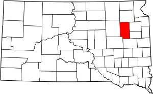 | |
| Towns | ||
| CDP | ||
| Unincorporated communities | ||
| ||
This article is issued from Wikipedia. The text is licensed under Creative Commons - Attribution - Sharealike. Additional terms may apply for the media files.