Willow Lake, South Dakota
Willow Lake is a city in Clark County, South Dakota, United States. The population was 263 at the 2010 census.
Willow Lake, South Dakota | |
|---|---|
City | |
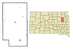 Location in Clark County and the state of South Dakota | |
| Coordinates: 44°37′40″N 97°38′17″W | |
| Country | United States |
| State | South Dakota |
| County | Clark |
| Incorporated | 1910[1] |
| Area | |
| • Total | 0.38 sq mi (0.98 km2) |
| • Land | 0.37 sq mi (0.96 km2) |
| • Water | 0.00 sq mi (0.01 km2) |
| Elevation | 1,785 ft (544 m) |
| Population | |
| • Total | 263 |
| • Estimate (2019)[4] | 243 |
| • Density | 653.23/sq mi (251.95/km2) |
| Time zone | UTC-6 (Central (CST)) |
| • Summer (DST) | UTC-5 (CDT) |
| ZIP code | 57278 |
| Area code(s) | 605 |
| FIPS code | 46-71940[5] |
| GNIS feature ID | 1259028[6] |
The city took its name from Willow Lake, a natural lake near the town site.[7]
Geography
Willow Lake is located at 44°37′40″N 97°38′17″W.[8]
According to the United States Census Bureau, the city has a total area of 0.37 square miles (0.96 km2), all land.[9]
Willow Lake has been assigned the ZIP code 57278 and the FIPS place code 71940.
Demographics
| Historical population | |||
|---|---|---|---|
| Census | Pop. | %± | |
| 1890 | 240 | — | |
| 1900 | 210 | −12.5% | |
| 1910 | 437 | 108.1% | |
| 1920 | 477 | 9.2% | |
| 1930 | 514 | 7.8% | |
| 1940 | 427 | −16.9% | |
| 1950 | 484 | 13.3% | |
| 1960 | 467 | −3.5% | |
| 1970 | 353 | −24.4% | |
| 1980 | 375 | 6.2% | |
| 1990 | 317 | −15.5% | |
| 2000 | 294 | −7.3% | |
| 2010 | 263 | −10.5% | |
| 2019 (est.) | 243 | [4] | −7.6% |
| U.S. Decennial Census[10] | |||
2010 census
As of the census[3] of 2010, there were 263 people, 115 households, and 68 families residing in the city. The population density was 710.8 inhabitants per square mile (274.4/km2). There were 129 housing units at an average density of 348.6 per square mile (134.6/km2). The racial makeup of the city was 92.0% White, 7.2% from other races, and 0.8% from two or more races. Hispanic or Latino of any race were 8.0% of the population.
There were 115 households, of which 27.0% had children under the age of 18 living with them, 44.3% were married couples living together, 9.6% had a female householder with no husband present, 5.2% had a male householder with no wife present, and 40.9% were non-families. 37.4% of all households were made up of individuals, and 23.5% had someone living alone who was 65 years of age or older. The average household size was 2.29 and the average family size was 3.03.
The median age in the city was 42.2 years. 26.2% of residents were under the age of 18; 11.9% were between the ages of 18 and 24; 14.4% were from 25 to 44; 28.9% were from 45 to 64; and 18.6% were 65 years of age or older. The gender makeup of the city was 50.6% male and 49.4% female.
2000 census
As of the census[5] of 2000, there were 294 people, 126 households, and 75 families residing in the city. The population density was 793.7 people per square mile (306.8/km2). There were 148 housing units at an average density of 399.6 per square mile (154.4/km2). The racial makeup of the city was 93.88% White, 5.10% Native American, and 1.02% from two or more races.
There were 126 households, out of which 28.6% had children under the age of 18 living with them, 50.0% were married couples living together, 7.1% had a female householder with no husband present, and 39.7% were non-families. 37.3% of all households were made up of individuals, and 23.0% had someone living alone who was 65 years of age or older. The average household size was 2.33 and the average family size was 3.11.
In the city, the population was spread out, with 31.3% under the age of 18, 3.4% from 18 to 24, 21.1% from 25 to 44, 22.4% from 45 to 64, and 21.8% who were 65 years of age or older. The median age was 38 years. For every 100 females, there were 94.7 males. For every 100 females age 18 and over, there were 88.8 males.
The median income for a household in the city was $30,625, and the median income for a family was $34,750. Males had a median income of $25,250 versus $20,833 for females. The per capita income for the city was $13,585. About 13.6% of families and 20.1% of the population were below the poverty line, including 29.3% of those under the age of eighteen and 20.3% of those 65 or over.
Notable people
- Art Fryslie, farmer and politician
- Clarence Gonstead, chiropractor, was born in Willow Lake
References
- "SD Towns" (PDF). South Dakota State Historical Society. Retrieved 2010-02-17.
- "2019 U.S. Gazetteer Files". United States Census Bureau. Retrieved July 30, 2020.
- "U.S. Census website". United States Census Bureau. Retrieved 2012-06-21.
- "Population and Housing Unit Estimates". United States Census Bureau. May 24, 2020. Retrieved May 27, 2020.
- "U.S. Census website". United States Census Bureau. Retrieved 2008-01-31.
- "US Board on Geographic Names". United States Geological Survey. 2007-10-25. Retrieved 2008-01-31.
- Federal Writers' Project (1940). South Dakota place-names, v.1-3. University of South Dakota. p. 69.
- "US Gazetteer files: 2010, 2000, and 1990". United States Census Bureau. 2011-02-12. Retrieved 2011-04-23.
- "US Gazetteer files 2010". United States Census Bureau. Retrieved 2012-06-21.
- "Census of Population and Housing". Census.gov. Retrieved June 4, 2015.
Municipalities and communities of Clark County, South Dakota, United States | ||
|---|---|---|
| Cities | 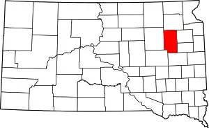 | |
| Towns | ||
| CDP | ||
| Unincorporated communities | ||
| ||