Cyclone Yali
Severe Tropical Cyclone Yali was one of seven severe tropical cyclones to develop during the 1997–98 South Pacific cyclone season. The system that was to become Yali was first noted as a tropical disturbance, to the northeast of Vanuatu during March 17. Over the next couple of days, the system moved towards the south-west and gradually developed further, before it was named Yali during March 19, after it had developed into a tropical cyclone. After it was named Yali re-curved and started moving towards the south-southeast, as the monsoonal flow to the north of the system strengthened. While the system was active, Yali affected Vanuatu and New Caledonia before the extra-tropical remnants impacted New Zealand where a man was killed and widespread power outages and damage were reported.
| Category 3 severe tropical cyclone (Aus scale) | |
|---|---|
| Category 2 tropical cyclone (SSHWS) | |
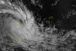
 Satellite image of Cyclone Yali | |
| Formed | March 18, 1998 |
| Dissipated | April 1, 1998 |
| (Extratropical after March 27, 1998) | |
| Highest winds | 10-minute sustained: 130 km/h (80 mph) 1-minute sustained: 165 km/h (105 mph) |
| Lowest pressure | 965 hPa (mbar); 28.5 inHg |
| Fatalities | 1 total |
| Damage | Minimal |
| Areas affected | Vanuatu, New Caledonia, New Zealand |
| Part of the 1997–98 South Pacific and the Australian region cyclone season | |
Meteorological history

The system that was to become Yali was first noted as a tropical disturbance, to the northeast of Vanuatu during March 17, by the United States Joint Typhoon Warning Center.[1][2] During that day, atmospheric convection over the disturbance's low level circulation center became better defined as it moved south-westwards, which prompted the JTWC to issue a tropical cyclone formation alert on the system, later that day.[1][2] The Fiji Meteorological Service subsequently started to monitor the disturbance, who described the system as a well defined area of low pressure.[3] During March 18, the JTWC initiated advisories and designated the system as Tropical Cyclone 29P, as the disturbance's organisation continued to improve and the monsoonal flow to the north of the system increased.[4]
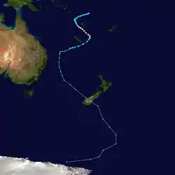
Over the next day the system moved towards the west-southwest between Vanuatu and the Solomon Islands under the influence of the subtropical ridge of high pressure to the south of the system.[4] The FMS subsequently reported at around 1800 UTC on March 19, that the system had developed into a Category 1 tropical cyclone on the Australian tropical cyclone intensity scale and named it Yali.[2][3] After it was named Yali re-curved and started moving towards the south-southeast, as the monsoon flow to the north of the system strengthened.[3][5]
Given the fact that Yali was in a region of warm sea surface temperatures and low wind shear, the agency predicted that the storm would intensify to a high-end Category 2 hurricane on the Saffir-Simpson Hurricane Scale.[6] After passing west of Vanuatu, this storm gradually intensified;[5] by March 21, the JTWC reported that Yali had intensified into a Category 1 hurricane.[6] The following day, Nadi estimated that Yali had become a Category 3 cyclone on the Australian intensity scale.
Early on March 22, the JTWC reported that Yali had peaked with 1-minute sustained wind speeds of 165 km/h (105 mph), which made it equivalent to a category 2 hurricane on the Saffir-Simpson hurricane wind scale.[2] At around the same time RSMC Nadi reported that the system had peaked with 10-minute sustained wind speeds of 130 km/h (80 mph).[2] During that day Yali passed about 100 km (60 mi) to the west of the capital city of Vanuatu: Port Villa, before passing over the Vanuatuan islands of Tanna and Aneityum.[7]
Shortly after its peak, thunderstorm activity began to decrease, and Yali started weakening. On March 22, the JTWC noted that winds had subsided to tropical storm status[6] while winds soon dropped below Category 2 intensity.[8] At around the same time, a mid-level subtropical ridge began to influence its motion, sending it to the west. As Yali moved to the southwest, the wind field became asymmetric. Based on Nadi data, by March 23, Yali was just east of Noumea, New Caledonia with winds of 50 mph (80 km/h). After passing south of New Caledonia, an upper-level low picked up the cyclone and induced cold air into the atmospheric circulation.[5]
Early on March 25, Yali had lost its tropical characteristics as an upper level low captured the system, with cold air working around the northern and western sides of the circulation.[5] However, the JTWC continued to monitor Yali as a tropical cyclone, while the system moved across 160°E and into the Australian region, where they were monitored by the Australian Bureau of Meteorology as an extratropical cyclone.[5]
By the next day, Yali's center was less than 300 mi (480 km) east-northeast of Brisbane, Australia. Despite a brief revival of convection, on the morning of March 27, the JTWC released its final bulletin on Yali. At this time, the low was located around 300 mi (480 km) east-southeast of Brisbane. The remnants of Yali went under a transformation in the Tasman Sea and respectively deepened south of New Zealand.[5]
The extratropical remnants of Yali were last noted by TCWC Wellington during March 31, while they were located about 3,350 km (2,080 mi) to the southeast of Wellington, New Zealand.[2] The remnants were subsequently absorbed into the circumpolar trough.[5]
Preparations, impact, and aftermath
Vanuatu
While Yali passed west of the Vanuatu Islands, it came close enough to affect the isles of Tanna and Aneityum. Tanna saw about 60–70% of its crops destroyed and about 30% of its homes damaged by the storm.[5] In Banana, vegetables and manioc crops, as well as fruit trees were entirely destroyed. In the atoll island of Aniwa, minor damage to houses and agriculture has been reported.[9] Other places in Vanuatu only received minor damage,[5] though Yali caused heavy rainfall and flooding throughout the island group and affected residents in low-lying areas and close to river banks. Throughout the county, some damage was recorded to local buildings and banana plantations were destroyed. During the aftermath of the storm, several evacuation centers were opened on the mainland to victims who had left their homes during the storm. The Government of Vanuatu sought support from the local Red Cross and other relief groups.[9] At peak intensity, Yali brushed Port Vila with 15 mph (24 km/h) winds (perhaps due to poor exposure of the instrument) and a peak pressure of 992 mbar (29.3 inHg).[5]
New Caledonia
Cyclone Yali passed just to the south of New Caledonia during March 23 and affected the Loyalty Islands, Isle of Pines and the southern half of Grande Terre.[10] On the Isle of Pines a rainfall total of 137 mm (5.4 in) and a peak wind gust of 126 km/h (78 mph) were recorded.[10] Other peak wind gusts of 162 km/h (101 mph) and 101 km/h (63 mph) were recorded in Cape N'Dua and La Roche.[10] Some damage was reported to Mare, Yate and the Isle of Pines with torn roofs and uprooted trees.[10]
New Zealand
Upon striking New Zealand as an extratropical storm, it caused high seas and flooding over South Island, Westport and Nelson.[5] One fatality occurred when a youth was swept away into the ocean in New Plymouth.[11] Trees were toppled, roofs were ripped off and power lines fell.[5] In addition, another person had to be rescued in Waikato. Because of high winds, trees were downed, trucks were blown across roads, and buildings were left without roofs. Yali also caused air travel difficulties in Wellington,[12] where a car was hit by a flying billboard. Tararuas recorded rainfall totals exceeding 4 in (100 mm). In addition, trees blown over by gales closed a major route between Nelson and Picton. High winds blew a roof in Hataitai. In Paraparaumu and Waikanae, a sudden period of heavy rain led to flooded basements. Due to a combination of rough seas and a high tide, a bay was flooded. Many inland roads became difficult to drive on and widespread power outages were reported. In all, only minor flooding was reported; the primary threat of Yali was high winds, not heavy rain. Due to the storm's rapid motion, the bulk of the rainfall fell within 12 hours.[11]
See also
References
- "Tropical Cyclone Formation Alert March 17, 1998 23z". United States Joint Typhoon Warning Center. Archived from the original on February 15, 2014. Retrieved February 15, 2014.
- "1998 Tropical Cyclone Yali (1998076S11170)". International Best Track Archive for Climate Stewardship. Retrieved October 9, 2019.
- Tropical Cyclone Season Summary 1997–98 (PDF) (Report). Fiji Meteorological Service. Archived from the original (PDF) on August 1, 2010. Retrieved February 8, 2014.
- Joint Typhoon Warning Center. "Tropical Cyclone 29P Warning 3 March 19, 1998 21z". United States Navy, United States Air Force. Archived from the original on February 15, 2014. Retrieved February 15, 2014.
- Padgett, Gary. Monthly Global Tropical Cyclone Summary March 1998 (Report). Archived from the original on February 22, 2012. Retrieved November 10, 2012.
- Tropical Cyclone Yali Warnings. Joint Typhoon Warning Center (Report). Australian Severe Weather. Retrieved November 10, 2012.
- Chappel Lori-Carmen; Bate Peter W (June 2, 2000). "The South Pacific and Southeast Indian Ocean Tropical Cyclone Season 1997–98" (PDF). Australian Meteorological Magazine. Australian Bureau of Meteorology. 49: 135–136. Archived (PDF) from the original on June 30, 2014. Retrieved July 1, 2014.
- MetService (May 22, 2009). "TCWC Wellington Best Track Data 1967–2006". International Best Track Archive for Climate Stewardship.
- Ochagva (April 3, 1998). "Vanuatu — Tropical Cyclones OCHA Situation Report No. 1". UN Office for the Coordination of Humanitarian Affairs. Retrieved November 10, 2012.
- Direction Interrégionale de la Nouvelle-Calédonie. "Cyclone Passes De 1880 à nos jours: Yali". Météo-France. Archived from the original on September 20, 2012. Retrieved February 28, 2015.
- March 1998 Southern NZ Ex-tropical Cyclone Yali 1998-03-28 (Report). NZ Historic Weather Events Catalog. Retrieved November 10, 2011.
- "World: Asia-Pacific 'Miracle' rescue of fisherman". BBC News. April 1, 1998. Retrieved November 10, 2012.
External links
- World Meteorological Organization
- Australian Bureau of Meteorology
- Fiji Meteorological Service
- New Zealand MetService
- Joint Typhoon Warning Center