Dadu District
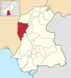
Dadu District (Sindhi: دادو), (Urdu: دادو) is a district of Sindh Province, Pakistan. With headquarters the city of Dadu, the district was created in 1931[2][3] by merging Kotri and Mahal Kohistan (later Jamshoro) tehsils from Karachi District and Mehar, Khairpur Nathan Shah, Dadu, Johi and Sehwan tehsils from Larkana District.[4] IN 2004, several talukas in the south were split off to create the new Jamshoro District.[5] Its boundary touches with four districts of Sindh i.e. Jamshoro, Naushahro Feroze, Shaheed Benazirabad and Kamber Shahdadkot.[6]
Dadu District
ضلعو دادو | |
|---|---|
 Dadu is located in the east of Sindh | |
| Country | Pakistan |
| Province | Sindh |
| Headquarters | Dadu |
| • District Nazim | (ISF) |
| Area | |
| • Total | 7,866 km2 (3,037 sq mi) |
| Population (2017)[1] | |
| • Total | 1,550,266 |
| • Density | 200/km2 (510/sq mi) |
| Time zone | UTC+5 (PST) |
| Area code(s) | 025 |
| Number of Tehsils | 4 |
Demographics
The predominant first language is Sindhi, which as of 1998 was natively spoken by 98.3% of the population of the talukas of Dadu, Johi, Khairpur Nathan Shah and Mehar.[7]
Natural reservoirs and irrigation sources
Dadu district is rich of natural resources. Valuable stones and reservoirs of petroleum and gas have been discovered in Taluka Johi. Moreover, Dadu Sugar Mill is a large scale industry at the district.[8]
Dadu District is irrigated through Sukkur Barrage with the two main canals i.e Rice canal and Dadu Canal. As well as land is irrigated by tube wells and spill over of River Indus during monsoon.[9]
Talukas
District Dadu has four Talukas, as tabulated below,:[10][11]
| Name | Status | Population
1998 Census |
Population
2017 Census |
Number of
Union Councils |
|---|---|---|---|---|
| Dadu | Taluka | 327,972 | 460,481 | 15 |
| Johi | Taluka | 207,383 | 294,848 | 10 |
| Khairpur Nathan Shah | Taluka | 253,309 | 334,258 | 12 |
| Mehar | Taluka | 318,053 | 460,679 | 15 |
The District has 14 Circles, 111 Tapa and 351 Dehs.
Places of interest
- Gorakh Hill - First hill station in Sindh
- Manchar Lake - Largest lake in Pakistan
- Jamia Mosque (Khudabad) - the oldest mosques in Dadu
- Yar Muhammad Kalhoro Tomb
- Ghazi Shah Mound
- Ancient graves in Wahi Pandhi
- Ali Murad Mound
- Ancient Rock Carvings of Sindh
- Thul Hairo Khan (Buddhist Stupa)
- Nai Gaj
- Nai Gaj Dam
- Necropolis of Mian Nasir Muhammad Kalhoro
- Cemetery of Mir Allahyar Talpur
- Shiva Mandir Johi
References
- "DISTRICT WISE CENSUS RESULTS CENSUS 2017" (PDF). www.pbscensus.gov.pk. Archived from the original (PDF) on 2017-08-29. Retrieved 2017-09-03.
- "About Dadu". hotfm.com.pk. Retrieved 2019-08-11.
- "District Courts of Sindh". www.districtcourtssindh.gos.pk. Retrieved 2019-08-11.
- "Archived copy". Archived from the original on 2014-07-19. Retrieved 2016-03-06.CS1 maint: archived copy as title (link)
- "Four new districts created in Sindh". 2004. Retrieved 26 December 2016.
- http://www.politicpk.com/dadu-district-uc-list-mna-mpa-seats-دادو-ضلع-کی-یونین-کونسلز
- PCO 2000, pp. 109–11.
- https://www.suhnisindh786.com/2020/04/dadu.html
- https://www.suhnisindh786.com/2020/04/dadu.html
- "Pakistan: Tehsils and Talukas (Districts and Subdistricts) - Population Statistics, Charts and Map". www.citypopulation.de. Retrieved 2020-02-23.
- "هنگامي امدادي سرگرمين جو منصوبو" (PDF). آفتن کان اڳواٽ بچاءُ ۽ انتظام ڪاريءَ وارو شعببو. 2011. Retrieved 2020-02-23.
Bibliography
- 1998 District census report of Dadu. Census publication. 82. Islamabad: Population Census Organization, Statistics Division, Government of Pakistan. 2000.
