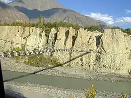
Danyor
Danyor (Urdu:دنیور, Burushiski and Shina: دیّور) is a city in the namesake sub-division[1] in Gilgit District lies across the river Gilgit in the outskirts of the capital of Gilgit-Baltistan. It is known for its green fields, and poplar trees. The world's highest paved road KKH passes through its landscape.
Danyor
| |
|---|---|
City | |
 Danyor is the location of the Danyor Suspension Bridge | |
 Danyor Location in Gilgit-Baltistan  Danyor Danyor (Pakistan) | |
| Coordinates: 35°55′10″N 74°23′20″E | |
| Country | |
| Autonomous state | |
| District | Gilgit |
| Elevation | 2,000 m (7,000 ft) |
| Population | |
| • Total | 25,000 |
| Demonym(s) | Bagoreh, Brusho |
| Time zone | UTC+5:30 (PST) |
| • Summer (DST) | +5 |
| Postal code | 15110 |
Important places
The Shrine of Shah Sultan Ali Arif above the Danyore tunnel,[2] the Chinese Graveyard near the Karakoram Highway and the rock inscriptions in the Chikas locality are the widely visited tourist attractions.[3] The Danyor Suspension Bridge, Danyore's New Beam Bridge ,Danyore's Old Beam Bridge, which was constructed over a half century ago, is quite a wonder; it connects the KIU Campus to the city. The Danyor end of the bridge enters single lane tunnel constructed by locals without any proper civil engineering equipments some five decades ago. The Danyor Springs under the broken Chinese Bridge are also the widely visited by local tourists during summers.[4][5]
Damaged Chinese Bridge of Danyor
One of earliest and longest composite bridges in Gilgit-Baltistan was the Chinese Bridge over river Gilgit on Karakoram Highway that partly collapsed in 2009 as a result of corroded pillar foundation. Initially two out of nine spans fell into the river and later in time due to unstable structure another pillar and third span were collapsed. The bridge is closed since then due to loss of connection and a new bridge is constructed near that is completed in April 2016. The bridge had two guard quarters at extremities each with patio and parapet and the parapets are decorated with qilins.[6] [7]
Health care
Danyor city has following healthcare facilities
- Aga Khan Health Centre
- Sehhat Foundation
- Al-Hayaat Medical Centre
Places nearby
References
- "گلگت۔ : اسسٹنٹ کمشنر سب ڈویژن دنیور کپٹن (ر) ثناء واللہ کا مجسٹریٹس اور بلڈنگ انسپکٹر ڈسٹرکٹ کونسل کے ہمراہ دنیور کے مختلف گورنمنٹ اور پرائیوٹ سکولوں کا دورہ کیا۔ - Passu Times پھسو ٹائمزاُردُو | We write, What is right". www.passutimes.net.
- Concrete social change will benefit Gilgit-Baltistan
- Pakistan's mountain farmers 'helpless' in face of erratic weather
- Concrete social change will benefit Gilgit-Baltistan-I
- Danyore Suspension Bridge and Tunnel It connects Gilgit City the region of District
- Danyore Bridge Damaged
- Shabbir Mir (25 July 2012). "Declared unsafe: Danyore bridge closed to traffic".
