Administrative units of Pakistan
The administrative units of Pakistan refers to the subnational administrative divisions that play a role in the governance of Pakistan. The country is composed of four provinces and one federal territory: the provinces of Balochistan, Punjab, Sindh, Khyber Pakhtunkhwa, and the federally-administered Islamabad Capital Territory. Additionally, Pakistan also administers two autonomous territories in the disputed region of Kashmir: Gilgit-Baltistan[Note 1] and Azad Jammu and Kashmir.[4][5] Due to the ongoing Kashmir dispute with neighbouring India, it also claims sovereignty over the union territories of Ladakh and Jammu and Kashmir, but has not exercised administrative authority over either region since its independence and subsequent war with India in 1947. Pakistan also claims sovereignty over the former princely state regions of Junagadh State and Manavadar State which are under the control of India since partition in 1947. All of Pakistan's provinces and territories are subdivided into divisions, which are further subdivided into districts, and then tehsils, which are again further subdivided into union councils.[6]
| Administrative Units of the Islamic Republic of Pakistan پاکستان کی انتظامی اکائیاں | |
|---|---|
 | |
| Category | Federated state |
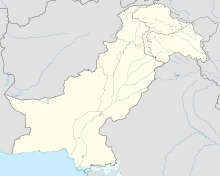
| Location | |
| Created | 1 July 1970 |
| Number | Provinces & Territories 4 Provinces 2 Autonomous Territories 1 Federal Territory 2 Claimed Areas (Administered by India) |
| Populations | Least: 1,249,000, Gilgit-Baltistan
Most: 110,012,442, Punjab |
| Areas | Smallest: 906.0 km2 (349.81 sq mi), Islamabad Capital Territory
Largest: 347,200 km2 (134,050 sq mi), Balochistan |
| Government | National government
|
| Subdivisions | Divisions, Districts, Tehsils, Union Council |
 |
|---|
| This article is part of a series on the politics and government of Pakistan |
|
|
History of Pakistan
Early history
Pakistan's provinces and territories were inherited from British India at independence on 14 August 1947. 2 days after independence, the Muslim-majority district of Murshidabad in Bengal moved from Pakistan to India due to an award by the Radcliffe Commission.[7] In 1947, Pakistan consisted of two wings, which were separated by 1600 kilometres of Indian territory. The western wing consisted of the merger of Northwest Frontier Province, West Punjab, and Sindh, the Baluchistan Chief Commissioners Province, thirteen princely states. The eastern wing consisted of East Bengal, the Chittagong Hill Tracts and Sylhet from the former British Raj province of Assam.
In 1948, Karachi was separated from Sindh to form the Federal Capital Territory. In 1950, the Northwest Frontier Province absorbed the princely states of Amb and Phulra while West Punjab renamed itself to Punjab. In 1952, the four princely states in the southwest formed the Baluchistan States Union.
In 1955, the One Unit Policy was launched by Muhammad Ali Bogra, whereby all the provinces and princely states of the western wing were merged and formed West Pakistan, with Lahore as the provincial capital. Simultaneously, East Bengal (including Sylhet and the Hill Tracts) was renamed to East Pakistan, with Dacca as the provincial capital. The One Unit Policy aimed to reduce expenditure and to eliminate provincial prejudices, but the military coup of 1958 signaled difficulties when the first military President, Ayub Khan, abolished the office of Chief Minister of West Pakistan in favour of Governor's rule.
On 7 September 1958, after four years of negotiations, including six months of intense negotiations, Pakistan purchased the Gwadar enclave from the government of Oman for 5.5 billion rupees/ USD $3 million (approx. $22,410,311.42 in 2017). Gwadar formally became part of Pakistan on 8 December 1958 after 174 years of Omani rule. In 1960, the federal capital moved from Karachi to Rawalpindi and in 1961, the Federal Capital Territory was merged into West Pakistan. In 1966, the capital was again moved to Islamabad. In 1962, Dacca was made the legislative capital of the country due to East Pakistan's high population.[8] In 1963, Pakistan entered into a treaty with China to transfer part of the Gilgit Agency to China (Shaksgam Valley—the Trans-Karakoram Tract) with the provision that the settlement was subject to the final solution of the Kashmir dispute.
Since 1970
In 1970, the second military President, Yahya Khan, abolished West Pakistan and established four new provinces: Sindh, Balochistan, Northwest Frontier Province and Punjab. In 1971, East Pakistan seceded to form Bangladesh in the Bangladesh Liberation War. In 1974, the remaining princely states of Hunza and Nagar were abolished and their territories merged into Gilgit Agency, to form the Northern Areas. In 1975, portions of the districts of Peshawar and Dera Ismail Khan were separated to form the Federally Administered Tribal Areas. In 1981, the region around Islamabad was separated from Punjab, and renamed to Islamabad Capital Territory.
In August 2000, divisions were abolished as part of a plan to restructure local government, followed by elections in 2001. Many of the functions previously handled by the provinces had been transferred to the districts and tehsils. In 2008, the government restored the former divisions and appointed commissioners.
In 2009, the Northern Areas were renamed to Gilgit-Baltistan and became a de facto province.[9][10] In 2010, the Northwest Frontier Province was renamed to Khyber Pakhtunkhwa.[11] In 2018, the National Assembly of Pakistan and Khyber Pakhtunkhwa Assembly passed the historic FATA Merger Bill - with the adoption of the Twenty-Fifth Amendment Act of 2018. On 31 May, the final step in the merger of the FATA with Khyber Pakhtunkhwa (KP) was completed, as President Mamnoon Hussain signed the 25th Constitutional Amendment Bill into law. Thus FATA status was abolished as a separate entity and was merged into Khyber Pakthunkhwa province.[12][13][14]
Tiers of Governance
The diagram below outlines the six tiers of government:
| Country (i.e. Pakistan) | |||||||||||||||||
| Province (e.g. Punjab Province) | |||||||||||||||||
| Division (e.g. Rawalpindi Division) | |||||||||||||||||
| District (e.g. Jhelum District) | |||||||||||||||||
| Tehsil (e.g. Sohawa Tehsil) | |||||||||||||||||
| Union Council (e.g. Domeli U.C.) | |||||||||||||||||
District
The District Coordination Officer is the administrative head of the District Administration. They have wide-ranging responsibility for overseeing, improving and directing the approved plans of the District Government.[15]
The Zila Nazim used to be the executive head of the District Administration until 2010 when the government gave their powers to the District Coordination Officers also. Their role is similar to district governor or prefect, with responsibility for implementing government strategy and developing initiatives arising out of it.[16]
In order to decentralize administrative and financial authority to be accountable to Local Governments, for good governance, effective delivery of services and transparent decision making through institutionalized participation of the people at grassroots level, elections to the local government institutions are held after every four years on none party basis by the Chief Election Commissioner of Pakistan.
Tehsil
Among the three tiers of local government, tehsil government is second tier of it. It is where the functions, responsibilities and authorities of districts government is divided into more smaller units, these units are known as "tehsils". The tehsils are used in all over the Pakistan except Sindh province where the word "taluka" is used instead, although the functions and authorities are same. The head of the Tehsil government is "Tehsil Nazim" who is assisted by the tehsil Naib-Nazim. Every tehsil has a Tehsil Municipal Administration, consisting of a tehsil council, Tehsil Nazim, tehsil/taluka municipal officer (TMO), chief officer and other officials of the local council.[17]
Union council
Members of union council including Union Administrator and Vice Union Administrator are elected through direct elections based on adult franchise and on the basis of joint electorate. However, for the election to the reserved seats for women in Zila Council proportionately divided among tehsils or towns shall be all members of the union councils in a tehsil or town. It is the responsibility of the Chief Election Commissioner to organize and conduct these elections.
Current administrative units
| Name (English) | Name (Urdu) | Status | Capital | Emblem | Flag | Map | Population (2017) |
Area (km2) |
Density (per km2) |
|---|---|---|---|---|---|---|---|---|---|
| Islamabad Capital Territory | اسلام آباد دار الحکومت | Capital Territory | Islamabad | N/A | N/A | _(claims_hatched).svg.png.webp) |
2,006,572 | 1,165 | 1,722 |
| Balochistan | بلوچستان | Province | Quetta |  |
.svg.png.webp) |
12,344,408 | 347,190 | 36 | |
| Khyber Pakhtunkhwa | خیبرپختونخوا | Province | Peshawar |  |
.svg.png.webp) |
35,525,047 | 101,741 | 349 | |
| Punjab | پنجاب | Province | Lahore | .svg.png.webp) |
110,012,442 | 205,344 | 536 | ||
| Sindh | سندھ | Province | Karachi |  |
.svg.png.webp) |
47,886,051 | 140,914 | 340 | |
| Gilgit-Baltistan[lower-alpha 1] | گلگت بلتستان | Administrative Territory | Gilgit | _(claims_hatched).svg.png.webp) |
1,249,000 | 72,971 | 17 | ||
| Azad Jammu & Kashmir[lower-alpha 1] | آزاد جموں و کشمیر | Self Governing Administrative Territory | Muzaffarabad | .png.webp) |
.svg.png.webp) |
4,045,366 | 13,297 | 304 | |
| Jammu & Kashmir[lower-alpha 1] including Ladakh[lower-alpha 1] | جموں و کشمیر اور لداخ | Indian Administered Union Territories
(Pakistan Perspective - Illegally Occupied since 1947) |
Srinagar | |
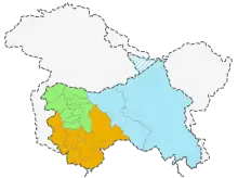
Kashmir (Green), Jammu (Orange) and Ladakh (Blue) |
12,548,925 | 101,387 | 124 | |
| Junagadh State[lower-alpha 1] including Manavadar State[lower-alpha 1] | جوناگڑھ اور منووادر | Indian Administered Territory in Gujarat
(Pakistan Perspective - Illegally Occupied since 1947) |
Junagadh | 
Pre 1947 |
Pre 1947 |
Junagadh & Manavadar in Gujarat |
~3,000,000 | 9,217 | 325 |
| Pakistan | پاکستان | Federated State | Islamabad | |
|
215 million
(230 million incl. Indian Administered Territories) |
882,622
(993,226 incl. Indian Administered Territories) |
244
(232 incl. Indian Administered Territories) |
See also
- Local government in Pakistan
- Cantonments (Pakistan), permanent military stations, which may include significant civilian populations
- Former administrative units of Pakistan
- Former Princely states of Pakistan
- Pakistani subnational abbreviations
- ISO 3166-2:PK
- List of cities in Pakistan
- List of capitals in Pakistan
- List of cities in Pakistan by population
- List of Pakistani provinces by gross domestic product
- List of administrative units of Pakistan by Human Development Index
Notes
- However, in November 2020, Pakistan's Prime Minister Imran Khan announced that Gilgit-Baltistan would attain Provisional Provincial status after the 2020 Gilgit-Baltistan Assembly election, being a long-standing demand of the people of Gilgit-Baltistan.[1][2][3]
- Disputed with India.
References
- "Fifth province". Fifth province | The Express Tribune. The Express Tribune. 2 November 2020. Archived from the original on 9 November 2020. Retrieved 14 November 2020.
- "Pakistani PM says he will upgrade status of part of Kashmir, angering India". Pakistani PM says he will upgrade status of part of Kashmir, angering India | Reuters. Reuters. 1 November 2020. Archived from the original on 2 November 2020. Retrieved 14 November 2020.
- "Gilgit-Baltistan to get provisional provincial status post-election: PM Imran". Gilgit-Baltistan to get provisional provincial status post-election: PM Imran. The News International. 2 November 2020. Retrieved 14 November 2020.
- Tikkanen, Amy; Gorlinski, Virginia; Javed, Murtaza; Tesch, Noah, eds. (20 July 1998). "Azad Kashmir | quasi-state, Kashmir region, India-Pakistan". Encyclopedia Britannica. Archived from the original on 12 October 2020. Retrieved 5 November 2020.
- "Pakistan's Gilgit-Baltistan: Between the Kashmir conflict and China". Pakistan's Gilgit-Baltistan: Between the Kashmir conflict and China. Retrieved 5 November 2020.
- "List of Districts, Tehsils/Talukas" (PDF). Pakistan Bureau of Statistics. July 2014. Retrieved 15 October 2016.
- "Murshidabad Govt Website". Archived from the original on 16 July 2014. Retrieved 17 December 2018.
- Pakistan Affairs. Information Division, Embassy of Pakistan. 1968. p. 19.
- "Northern Areas renamed Gilgit-Baltistan Poll for assembly, CM in Nov Regional groups unhappy: Autonomy package for NAs approved". DAWN. 30 August 2009.
- "Disputed Northern Areas renamed as Gilgit-Baltistan". Hindustan Times. 30 August 2009.
- "From NWFP to Khyber Pakhtunkhwa". DAWN. 1 April 2010.
- "New dawn for FATA as K-P approves merger - The Express Tribune". 27 May 2018.
- Hayat, Arif (27 May 2018). "KP Assembly approves landmark bill merging Fata with province".
- Wasim, Amir (31 May 2018). "President signs KP-Fata merger bill into law".
- DCO job description Archived 2013-04-30 at the Wayback Machine
- Zila Nazim job description Archived 2007-07-04 at the Wayback Machine
- Ebel, Robert E. (January 2006). "Administrative Structure of the Tehsil Municipal Administration". Research Gate. Retrieved 6 September 2020.
External links
- Government of Azad Jammu & Kashmir
- Government of Balochistan
- Government of Gilgit-Baltistan
- Government of Islamabad Capital Territory
- Government of Khyber Pakhtunkhwa
- Government of Punjab
- Government of Sindh
| Provinces | ||
|---|---|---|
| Territories | ||
| Autonomous regions | ||
See also: Former administrative units of Pakistan | ||
Pakistan articles | |||||||||||||||||||
|---|---|---|---|---|---|---|---|---|---|---|---|---|---|---|---|---|---|---|---|
| |||||||||||||||||||
| |||||||||||||||||||
| |||||||||||||||||||
| |||||||||||||||||||
| |||||||||||||||||||
| |||||||||||||||||||