Datu Piang, Maguindanao
Datu Piang, officially the Municipality of Datu Piang (Maguindanaon: Ingud nu Datu Piang; Iranun: Inged a Datu Piang; Tagalog: Bayan ng Datu Piang), is a 2nd class municipality in the province of Maguindanao, Philippines. According to the 2015 census, it has a population of 25,600 people. [3]
Datu Piang | |
|---|---|
| Municipality of Datu Piang | |
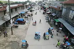 Downtown area | |
 Seal | |
 Map of Maguindanao with Datu Piang highlighted | |
OpenStreetMap 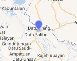
| |
.svg.png.webp) Datu Piang Location within the Philippines | |
| Coordinates: 7°01′04″N 124°29′51″E | |
| Country | |
| Region | Bangsamoro Autonomous Region in Muslim Mindanao (BARMM) |
| Province | Maguindanao |
| District | 2nd District |
| Founded | November 25, 1936 |
| Barangays | 16 (see Barangays) |
| Government | |
| • Type | Sangguniang Bayan |
| • Mayor | Victor T. Samama |
| • Vice Mayor | Nasser S. Abpi |
| • Representative | Esmael G. Mangudadatu |
| • Electorate | 14,515 voters (2019) |
| Area | |
| • Total | 302.97 km2 (116.98 sq mi) |
| Elevation | 9.0 m (29.5 ft) |
| Highest elevation | 91 m (299 ft) |
| Lowest elevation | −2 m (−7 ft) |
| Population | |
| • Total | 25,600 |
| • Density | 84/km2 (220/sq mi) |
| • Households | 4,167 |
| Economy | |
| • Income class | 2nd municipal income class |
| • Poverty incidence | 57.52% (2015)[4] |
| • Revenue | ₱100,072,933.54 (2016) |
| Service provider | |
| • Electricity | Maguindanao Electric Cooperative |
| Time zone | UTC+8 (PST) |
| ZIP code | 9607 |
| PSGC | |
| IDD : area code | +63 (0)64 |
| Climate type | tropical climate |
| Native languages | Maguindanao Tagalog |
| Website | www |
It is formerly known as Dulawan.
History
Created as Dulawan on November 25, 1936 by Executive Order No. 66[5] of Pres. Manuel L. Quezon, the municipality covered a large area of what is now mostly central Maguindanao and northern Sultan Kudarat. It is among the first municipalities of the old Cotabato province. Republic Act No. 1035, enacted on June 12, 1954 renamed the town to Datu Piang,[6] after an influential Muslim leader from the region during the American colonial period.[7]
In 1959, a large southern territory was made into the municipality of Ampatuan. Four years later the municipality of Maganoy was carved out its territory, which later on became the capital of Maguindanao, of which it was made part of on November 22, 1973.[8] Its remaining south-western barangays were merged with other barangays of Dinaig to form the municipality of Talayan in 1976.[9] Its area was reduced again on July 1, 2003, when 14 of its south-eastern barangays were separated to form the municipality of Datu Saudi-Ampatuan.[10]
On July 30, 2009, upon the ratification of Muslim Mindanao Autonomy Acts No. 225 (as amended by MMAA 252) and MMAA 222 (as amended by MMAA 253), the municipalities of Shariff Saydona Mustapha and Datu Salibo, respectively, were created from a total of 5 entire barangays and portions of 10 barangays from Datu Piang, in addition to other barangays from Datu Saudi-Ampatuan, Datu Unsay, Mamasapano and Shariff Aguak.
On December 3, 2020, at around 10:45 in the evening, around 100 members of the Bangsamoro Islamic Freedom Fighters (BIFF) attacked and assaulted three Philippine Army detachments in the municipality. The firefight lasted for about an hour and a grenade was thrown at a police car which caught fire and exploded. There were no reported civilian and military casualties.[11][12][13] The Philippine National Police announced that they would file cases against BIFF leaders responsible for the attack.[14]
Geography
Barangays
Datu Piang is politically subdivided into 16 barangays.[15]
- Alonganan
- Ambadao
- Balanakan
- Balong
- Buayan (Rajahbuayan Mopakc)
- Dado
- Damabalas
- Duaminanga
- Kalipapa (Mopak)
- Kanguan[fn 1]
- Liong
- Magaslong
- Masigay
- Montay
- Poblacion (Dulawan)
- Reina Regente
Climate
| Climate data for Datu Piang, Maguindanao | |||||||||||||
|---|---|---|---|---|---|---|---|---|---|---|---|---|---|
| Month | Jan | Feb | Mar | Apr | May | Jun | Jul | Aug | Sep | Oct | Nov | Dec | Year |
| Average high °C (°F) | 32 (90) |
32 (90) |
33 (91) |
33 (91) |
32 (90) |
31 (88) |
30 (86) |
31 (88) |
31 (88) |
31 (88) |
31 (88) |
31 (88) |
32 (89) |
| Average low °C (°F) | 21 (70) |
21 (70) |
21 (70) |
22 (72) |
23 (73) |
23 (73) |
23 (73) |
23 (73) |
23 (73) |
23 (73) |
23 (73) |
22 (72) |
22 (72) |
| Average precipitation mm (inches) | 19 (0.7) |
14 (0.6) |
15 (0.6) |
18 (0.7) |
33 (1.3) |
42 (1.7) |
44 (1.7) |
42 (1.7) |
30 (1.2) |
31 (1.2) |
28 (1.1) |
17 (0.7) |
333 (13.2) |
| Average rainy days | 6.9 | 5.6 | 6.9 | 8.1 | 15.1 | 17.5 | 17.8 | 18.5 | 14.9 | 14.9 | 12.4 | 8.0 | 146.6 |
| Source: Meteoblue (modeled/calculated data, not measured locally) [17] | |||||||||||||
Demographics
|
| ||||||||||||||||||||||||||||||||||||||||||||||||
| Source: Philippine Statistics Authority [3] [18] [19][20] | |||||||||||||||||||||||||||||||||||||||||||||||||
Economy
| Poverty Incidence of Datu Piang | |
| Source: Philippine Statistics Authority[21][22][23][24][25][26] | |
Notes
- Created by MMA ACT. NO. 232 on December 6, 2008[16]
References
- Municipality of Datu Piang | (DILG)
- "Province: Maguindanao". PSGC Interactive. Quezon City, Philippines: Philippine Statistics Authority. Retrieved 12 November 2016.
- Census of Population (2015). "ARMM – Autonomous Region in Muslim Mindanao". Total Population by Province, City, Municipality and Barangay. PSA. Retrieved 20 June 2016.
- https://psa.gov.ph/sites/default/files/City%20and%20Municipal-level%20Small%20Area%20Poverty%20Estimates_%202009%2C%202012%20and%202015_0.xlsx; publication date: 10 July 2019; publisher: Philippine Statistics Authority.
- Municipality of Datu Piang (2002-05-07). "Municipal Basic Date". Retrieved 2008-05-19.
- Chan Robles Virtual Law Library (1998-07-19). "Republic Act No. 1035". Retrieved 2008-05-19.
- University of California Press. "Muslim Rulers and Rebels: Chapter 5 - America's Moros". Retrieved 2008-05-19.
- Chan Robles Virtual Law Library (1998-07-19). "Presidential Decree No. 341". Retrieved 2008-05-18.
- Chan Robles Virtual Law Library (1998-07-19). "Presidential Decree No. 1009". Retrieved 2008-05-18.
- Philippine Statistics Authority (2008-04-16). "2007 Census of Population - ARMM" (PDF). Archived from the original (PDF) on 2008-09-05. Retrieved 2008-05-19.
- "Message from our Mayor, Datu Victor T. Samama, Al hadj". Bayan Ng Datupiang on Facebook. December 4, 2020. Retrieved December 5, 2020.
- Mindanews (2020-12-03). "Datu Piang town under siege but military says situation under control". MindaNews. Retrieved 2020-12-05.
- Cabrera, Ferdinandh B. (2020-12-04). "Residents say teenage boys were among those who attacked Datu Piang". MindaNews. Retrieved 2020-12-05.
- Santos, Elmor (December 4, 2020). "PNP readies complaints against BIFF leaders for Datu Piang attack". CNN Philippines. Retrieved December 5, 2020.
- National Statistical Coordination Board. "PSGC Interactive: Municipality/City: DATU PIANG". Archived from the original on 2008-11-19. Retrieved 2009-02-25.
- "PSGC Updates (October - December 2008)". National Statistical Coordination Board. Archived from the original on 2009-11-13. Retrieved 2009-02-25.
- "Datu Piang, Maguindanao : Average Temperatures and Rainfall". Meteoblue. Retrieved 19 January 2019.
- Census of Population and Housing (2010). "ARMM – Autonomous Region in Muslim Mindanao". Total Population by Province, City, Municipality and Barangay. NSO. Retrieved 29 June 2016.
- Censuses of Population (1903–2007). "ARMM – Autonomous Region in Muslim Mindanao". Table 1. Population Enumerated in Various Censuses by Province/Highly Urbanized City: 1903 to 2007. NSO.
- "Province of Maguindanao". Municipality Population Data. Local Water Utilities Administration Research Division. Retrieved 17 December 2016.
- "Poverty incidence (PI):". Philippine Statistics Authority. Retrieved 28 December 2020.
- https://psa.gov.ph/sites/default/files/NSCB_LocalPovertyPhilippines_0.pdf; publication date: 29 November 2005; publisher: Philippine Statistics Authority.
- https://psa.gov.ph/sites/default/files/2003%20SAE%20of%20poverty%20%28Full%20Report%29_1.pdf; publication date: 23 March 2009; publisher: Philippine Statistics Authority.
- https://psa.gov.ph/sites/default/files/2006%20and%202009%20City%20and%20Municipal%20Level%20Poverty%20Estimates_0_1.pdf; publication date: 3 August 2012; publisher: Philippine Statistics Authority.
- https://psa.gov.ph/sites/default/files/2012%20Municipal%20and%20City%20Level%20Poverty%20Estima7tes%20Publication%20%281%29.pdf; publication date: 31 May 2016; publisher: Philippine Statistics Authority.
- https://psa.gov.ph/sites/default/files/City%20and%20Municipal-level%20Small%20Area%20Poverty%20Estimates_%202009%2C%202012%20and%202015_0.xlsx; publication date: 10 July 2019; publisher: Philippine Statistics Authority.
External links
- Datu Piang Profile at PhilAtlas.com
- Philippine Standard Geographic Code
- 1995 Philippine Census Information
- 2000 Philippine Census Information
- 2007 Philippine Census Information
- Local Governance Performance Management System
Buluan (capital) | |
| Municipalities |
|
| Independent component city |
|
| Authority control |
|
|---|
