Deir al-Adas
Deir al-Adas (Arabic: دير العدس) is a village in southern Syria, administratively part of the Daraa Governorate. It is situated about 40 kilometers northwest of Daraa. According to the Central Bureau of Statistics (CBS), it had a population of 3,723.[1]
Deir al-Adas
دير العدس | |
|---|---|
Village | |
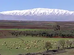 Deir al-Adas with Mount Hermon in the background | |
 Deir al-Adas | |
| Coordinates: 33°9′38″N 36°7′28″E | |
| Grid position | 255/285 PAL |
| Country | |
| Governorate | Daraa Governorate |
| District | Al-Sanamayn District |
| Nahiyah | Ghabaghib |
| Elevation | 800 m (2,600 ft) |
| Population (2004 census) | |
| • Total | 3,273 |
| Time zone | UTC+2 (EET) |
| • Summer (DST) | UTC+3 (EEST) |
| Website | http://www.discover-syria.com/ |
The name means Monastery (deir) of the Lentils (al-'adas).
History
In 1838, Deir al-Adas was noted as a village in the el-Jeidur district.[2]
See also
References
- General Census of Population and Housing 2004. Syria Central Bureau of Statistics (CBS). Homs Governorate. (in Arabic)
- Robinson and Smith, 1841, vol 3, 2nd appendix, p. 149
Bibliography
External links
- http://www.discover-syria.com
- Map of town, Google Maps
- Sanameine-map, 19L
Capital: Daraa | |||||||||||||||||||||
| |||||||||||||||||||||
| |||||||||||||||||||||
| |||||||||||||||||||||
This article is issued from Wikipedia. The text is licensed under Creative Commons - Attribution - Sharealike. Additional terms may apply for the media files.