Tubna
Tubna (Arabic: تبنة, also spelled Tibna or Tebnah) is a village in southern Syria, administratively part of the Daraa Governorate in the Hauran region. It is located 58 km south Damascus and 42 km from Daraa.
Tubna
تبنة | |
|---|---|
Village | |
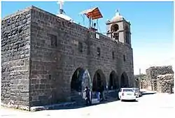 A church in Tubna | |
 Tubna Location in Syria | |
| Coordinates: 32°59′33″N 36°13′0.8″E | |
| Grid position | 264/266 |
| Country | |
| Governorate | Daraa |
| District | Al-Sanamayn |
| Subdistrict | Al-Sanamayn |
| Elevation | 650 m (2,130 ft) |
| Population (2004 census) | |
| • Total | 1,272 |
| • Official languages | Arabic |
| Time zone | UTC+2 (EET) |
| • Summer (DST) | UTC+3 (EEST) |
History
Tubna was the seat of a Monophysite monastery by the second half of the 6th century.[1] The Byzantine Empire’s Ghassanid Arab vassals apparently maintained a presence in Tubna as evidenced by a verse by the contemporary poet al-Nabigha that placed the tomb of the Ghassanid emir between “Tubna and Jasim”.[1] Moreover, the Ghassanids were adamant supporters of the Monophysite church and their relationship with Tubna may have been based on their support for its monastery.[1]
The Syrian geographer Yaqut al-Hamawi noted in the 1220s that Tubna was "a town of the Hauran, belonging to the Damascus Province".[2]
Ottoman era
In 1596 Tubna appeared in the Ottoman tax registers as Tibna and was part of the nahiya (subdistrict) of Bani Kilab in the Hauran Sanjak. It had an entirely Muslim population consisting of 30 households and 25 bachelors. The villagers paid a fixed tax rate of 40% on wheat, barley, summer crops, goats and beehives; a total of 16,460 akçe. 2,5/24 of the revenue went to a waqf.[3]
In 1838, Tibny was noted as a Muslim village, situated "the Nukra, north of Al-Shaykh Maskin".[4]
Demographics
According to the Syria Central Bureau of Statistics (CBS), Tubna had a population of 1,272 in 2004.[5] The inhabitants are predominantly Melkite Greek Catholics.[6] The village is among the handful of Melkite villages that straddle the hills separating the Hauran plain and Jabal al-Druze massif.[6]
References
- Shahid 2002, p. 228.
- Le Strange, 1890, p. 546
- Hütteroth and Abdulfattah, 1977, p. 209.
- Robinson and Smith, 1841, vol 3, 2nd appendix, p. 151
- General Census of Population and Housing 2004. Syria Central Bureau of Statistics (CBS). Daraa Governorate. (in Arabic)
- Dick, Marlin (May–June 2004). "Deep Roots in a Fertile Land". ONE Magazine. Catholic Near East Welfare Association. Retrieved 4 November 2018.
Bibliography
- Hütteroth, Wolf-Dieter; Abdulfattah, Kamal (1977). Historical Geography of Palestine, Transjordan and Southern Syria in the Late 16th Century. Erlanger Geographische Arbeiten, Sonderband 5. Erlangen, Germany: Vorstand der Fränkischen Geographischen Gesellschaft. ISBN 3-920405-41-2.
- Le Strange, G. (1890). Palestine Under the Moslems: A Description of Syria and the Holy Land from A.D. 650 to 1500. Committee of the Palestine Exploration Fund.
- Robinson, E.; Smith, E. (1841). Biblical Researches in Palestine, Mount Sinai and Arabia Petraea: A Journal of Travels in the year 1838. 3. Boston: Crocker & Brewster.
External links
- Map of town, Google Maps
- Naoua-map; 20L
- www.khabab.net
- http://www.esyria.sy/edaraa/index.php?p=stories&category=places&filename=200802241815014
Capital: Daraa | |||||||||||||||||||||
| |||||||||||||||||||||
| |||||||||||||||||||||
| |||||||||||||||||||||