Del Rey, Los Angeles
Del Rey is a neighborhood in the Westside of Los Angeles, surrounded on three sides by Culver City, California. Within it lie a police station, a public middle school and six public elementary schools. It is served by a neighborhood council and a residents association. Del Rey, with a 32,000+ population, has a large number of military veterans.
Del Rey | |
|---|---|
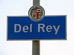 Del Rey signage located at the intersection of Centinela Avenue & Washington Boulevard | |
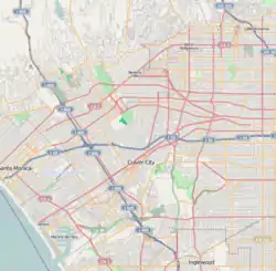 Del Rey Location within Western Los Angeles | |
| Coordinates: 33.98528°N 118.42444°W | |
| Country | |
| State | |
| County | |
| Time zone | Pacific |
| Zip Code | 90066 |
| Area code(s) | 310 |
Geography
According to the Mapping L.A. project of the Los Angeles Times, Del Rey is surrounded on the northwest, north, northeast and east by Culver City, on the southeast by Playa Vista, on the southwest and west by Marina del Rey and on the northwest by Venice. Its southern apex touches the northeast corner of Playa del Rey.[1][2]
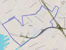
Street and other boundaries are: the Culver City line on the northwest, and northeast, Ballona Creek and Centinela Creek on the southeast and Lincoln Boulevard on the southwest.[3][4]
It is further divided into 8 census tracts that form the Del Rey Neighborhood Council's Areas A through H.[5]
Population
The 2000 U.S. census counted 28,010 residents in the 2.45-square-mile Del Rey neighborhood—an average of 11,420 people per square mile, about the norm for Los Angeles; in 2008, the city estimated that the population had increased to 32,976. The median age for residents was 35, considered the average for Los Angeles; the percentage of residents aged 19 through 34 was among the county's highest.[3]
The neighborhood was highly diverse ethnically. The breakdown was Latinos, 44.3%; whites, 34.0%; Asians, 14.1%; blacks, 4.4%, and others, 3.2%. Mexico (53.3%) and the Philippines (7.0%) were the most common places of birth for the 37.9% of the residents who were born abroad—about an average figure for Los Angeles.[3]
The median yearly household income in 2008 dollars was $62,259, an average figure for Los Angeles. The average household size of 2.5 people was about the same as the city as a whole. Renters occupied 55.2% of the housing stock and house- or apartment owners held 44.8%.[3]
The percentages of never-married men (42.9%) and divorced women (12.7%) were among the county's highest. In 2000, there were 1,846 veterans, or 8.4%, a high rate for Los Angeles.[3]
Police service
The Los Angeles Police Department operates the Pacific Community Police Station at 12312 Culver Boulevard, 90066, serving the neighborhood as well as Westchester and Venice.[6][7]
Fire service
Del Rey is served by the Los Angeles Fire Department. Station 67 is located within Del Rey on Playa Vista Drive.[8] Parts of Del Rey are also served by LAFD Station 63 (Venice) and Station 62 (Mar Vista).
Education
Thirty percent of Del Rey residents aged 25 and older had earned a four-year degree by 2000, an average figure for both the city and the county.[3]
The schools within Del Rey are as follows:[9]
- Culver City Christian School, private elementary, 11312 Washington Boulevard
- Stoner Avenue Elementary School, LAUSD, 11735 Braddock Drive
- ICEF Vista Elementary Academy, charter school, 4471 Inglewood Boulevard
- Braddock Drive Elementary School, LAUSD, 4711 Inglewood Boulevard
- Short Avenue Elementary School, LAUSD, 12814 Maxella Avenue
- Marina del Rey Middle School, LAUSD, 12500 Braddock Drive
- Ocean Charter School, charter elementary, 12606 Culver Boulevard
- Goethe International Charter School, charter elementary, 12500 Braddock Drive
References and notes
- "Westside," Mapping L.A., Los Angeles Times
- "South Bay," Mapping L.A., Los Angeles Times
- "Del Rey," Mapping L.A., Los Angeles Times
- The Thomas Guide: Los Angeles County, 2004, pages 671 and 672
- "Del Rey". delreync.org. Retrieved 2018-11-10.
- lapdonline.org
- Location of the police station in Del Rey
- "Find Your Station | Los Angeles Fire Department". www.lafd.org. Retrieved 2018-11-10.
- "Del Rey Schools," Mapping L.A., Los Angeles Times
External links
- Del Rey Neighborhood Council
- Del Rey Residents Association
- Del Rey crime map and statistics
| By topic |  | |
|---|---|---|
| Government | ||
Westside region, Los Angeles | ||
|---|---|---|
| Districts and neighborhoods |
|  |
| Points of interest | ||
| Neighboring cities and communities | ||