Pacific Palisades, Los Angeles
Pacific Palisades is a largely residential neighborhood in the Westside of the city of Los Angeles, California, located among Brentwood to the east, Malibu and Topanga to the west, Santa Monica to the southeast, the Santa Monica Bay to the southwest, and the Santa Monica Mountains to the north. It is about 7 miles (11 kilometers) west of the UCLA campus.[1] The Santa Monica Mountain range runs through the northern and eastern sections of Pacific Palisades, with Topanga State Park accessible through a series of trailheads.[1]
Pacific Palisades | |
|---|---|
 Pacific Palisades and Will Rogers State Beach, California | |
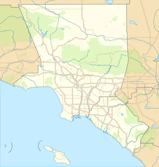 Pacific Palisades Location within Los Angeles County | |
| Coordinates: 34.04806°N 118.52556°W | |
| Country | |
| State | |
| County | |
| City | |
| Population (2018) | |
| • Total | 28,000 |
| Time zone | UTC-8 (Pacific) |
| • Summer (DST) | UTC-7 (PDT) |
| Area code(s) | 310/424 |
History
Archeological evidence shows Native American Indians living in the Santa Monica Mountains and the surrounding area including Pacific Palisades for over 10,000 years.[2] Prior to European contact, the western sections of the Santa Monica mountains were inhabited by the Tongva people.[2] The closest Tongva settlement to Pacific Palisades with a written record is the village of Topa'nga.[3] The village of Topa'nga sits on the western-most edge of Tongva territory, neighboring the territory of the Chumash people to the north.[3] Due to this close proximity to the Chumash, the culture in western Tongva territory contained elements of Chumash influence.[3]
The land that became Pacific Palisades was originally located within the boundaries of Rancho Boca de Santa Monica, granted by the governor of California during the Mexican period to Francisco Marquez and Ysidro Reyes in 1839.[3] The Ysidro Reyes Adobe was the first adobe home ever built in Santa Monica Canyon, erected in the year 1838 on land now known as Pampas Ricas Blvd, located in Pacific Palisades.[4] Sketches of adobe dwelling exist in the collection of the UCLA Library.[5][6] A memorial plaque sits in a boulder on Pampas Ricas Blvd commemorating the adobe house, dedicated in the 1950s.[7] Ysidro Reyes died in 1863. Reyes left his portion of Rancho Boca de Santa Monica to his widow, Maria Antonia Villa, who sold it to developer and railroad magnate Robert Symington Baker in 1875.[8]
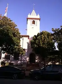
In 1911, film director Thomas Ince created his Western film factory, "Inceville", which at its peak employed nearly 600 people. A decade later, the Rev. Charles H. Scott and the Southern California Methodist Episcopal Church bought the land; in 1922, Scott founded Pacific Palisades, envisioning an elaborate religious-intellectual commune.[9] Believers snapped up choice lots and lived in tents during construction. By 1925, the Palisades had 100 homes. In one subdivision, streets were named for Methodist missionaries. The tents eventually were replaced by cabins, then by bungalows, and ultimately by multimillion-dollar homes. The climate of the area was a big selling point. Temperatures are much cooler than inland Los Angeles during summer, but usually sunnier and less foggy than areas south along the coast (e.g. Santa Monica).
During their exile from Nazi Germany in the 1930s and 40s, many German and Austrian intellectuals and artists associated with the Exilliteratur settled in Pacific Palisades, including Thomas Mann and his wife Katia Mann (at 1550 San Remo Drive),[10] Lion Feuchtwanger, Theodor W. Adorno, Vicki Baum, Oskar Homolka and Emil Ludwig.[11] Villa Aurora on Paseo Miramar, the Spanish colonial home of Feuchtwanger and his wife, Marta, became the focal point of the expatriate community, which was nicknamed "Weimar by the Sea".[12]
For many decades there was a virtual ban on drinking alcohol in the district, and a Chinese restaurant, House of Lee, held the only liquor license. The Methodist Church created a Chautauqua Conference Grounds in Temescal Canyon.[13] The Presbyterian Synod purchased the property in 1943 and used it as a private retreat center until the Santa Monica Mountains Conservancy purchased the property in 1994 to become Temescal Gateway Park.
Geography
Neighborhoods
- The Via Bluffs and The Huntington Palisades are the neighborhoods that border the "village" proper to the south of Sunset Boulevard , overlooking the ocean. The Via Mesa is located between Temescal Canyon on the west and Potrero Canyon on the east; the Huntington Palisades is located between Potrero Canyon on the west and Chautauqua Boulevard on the east. Both of these neighborhoods are within walking distance to The Village and sit upon high bluffs that look out over the Pacific Ocean.
- The El Medio Bluffs is located south of Sunset Boulevard beginning about 1⁄4 mile (400 meters) west of The Village, across Temescal Canyon – just past Palisades Charter High School. The El Medio Mesa extends for a long distance from Temescal Canyon all the way to where Sunset Boulevard meets the Pacific Coast Highway. As with The Via Bluffs and The Huntington Palisades, The El Medio Bluffs are located on a high ridge overlooking the Pacific Ocean.
- Castellammare is located along Pacific Coast Highway on small bluffs much closer to sea-level, north of where Sunset Boulevard meets PCH. This is the home of the Getty Villa and the narrow, winding streets in this neighborhood have Italian names and ocean breezes.[14]
- Palisades Highlands is a community near the end of Sunset Blvd., bordering Topanga, about five minutes away from the center of Pacific Palisades (The Village).[15] The Highlands is a neighborhood located in Santa Ynez Canyon above the Palisades proper and is only accessible via Palisades Drive. The Highlands is located in a valley of Santa Ynez Canyon and is made up of several mini-communities built in the 1990s. The Highlands has access to multiple hiking trails of Topanga State Park due to its high elevation and its jutting into the Santa Monica Mountains. [16]
- Rustic Canyon is the neighborhood east of Chautauqua Boulevard that dips into Santa Monica Canyon and includes the Will Rogers State Historic Park.[17]
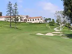
- The Riviera is a Palisades neighborhood two miles (three kilometers) east of the community's Village and features The Riviera Country Club, a country club, and streets named after various locations in the French and Italian Riviera. The neighborhood is divided into north and south sections by Sunset Boulevard. It borders Santa Monica and Brentwood. The Riviera Country Club hosts the Genesis Open on the PGA Tour in February (the tournament has been previously known as the Northern Trust Open and Nissan Open and was originally the "Los Angeles Open"). Riviera has hosted three major championships: the U.S. Open in 1948 and the PGA Championship in 1983 and 1995. Ben Hogan won three times in less than 18 months at the course (1947 and 1948 L.A. Open, 1948 U.S. Open), and it became known as "Hogan's Alley." The country club will also host golf during the 2028 Summer Olympics.[18]
Demographics
In 2009 the Los Angeles Times's "Mapping L.A." project supplied these Pacific Palisades statistics: a population of 25,507 residents in the 22.84 sq mi (59.2 km2) neighborhood, giving a population density of 1,048/sq mi (405/km2), among the lowest for the city and the county.[19]
Parks and recreation
Every Fourth of July, the community's Chamber of Commerce sponsors day-long events which include 5K and 10K runs, a parade down Sunset Boulevard, and a concert and fireworks display at Palisades High School baseball field. The district also includes some large parklands and many hiking trails.
The Los Angeles Department of Recreation and Parks operates several recreational facilities in Pacific Palisades.
- Palisades Park, at 851 Alma Real Drive, has 117 acres (47 hectares) of land.[20] The Palisades Recreation Center, also at that address, has barbecue pits, four baseball diamonds (two lighted, two unlighted), lighted basketball courts (indoor and outdoor), a children's play area, a football field, an indoor gymnasium (no weights are offered), picnic tables, lighted tennis courts, and lighted volleyball courts. The facility also has a kitchen, a stage, a television area, and various scheduled athletic and non-athletic activities.[21] The Pacific Palisades Tennis Court, also at that address, has eight courts.[22]
- Rustic Canyon Park is located along Rustic Canyon Road.[23] The Rustic Canyon Pool is located at 601 Latimer Road.[24] The Rustic Canyon Recreation Center, located at the same address, has a multipurpose with a capacity of 150 people that can be used as an auditorium, a gymnasium, or a volleyball court. The center also has barbecue pits, an unlighted baseball diamond, basketball courts (lighted indoor and unlighted outdoor), a children's play area, an indoor gymnasium (no weights are offered), picnic tables, and volleyball courts (lighted and unlighted).[25]
- Temescal Canyon Park is a non-staffed "pocket park" located along Temescal Canyon Drive from Pacific Coast Highway to Sunset Blvd. The park has barbecue pits, a children's play area, picnic tables, hiking trails, a native garden, and toilets.[26]
- Santa Ynez Canyon Park is located at Palisades Drive and Avenida de Santa Ynez.[27]
- Rivas Canyon Park is located at the east terminus of Oracle Place.[28]
The California Department of Parks and Recreation also has locations in Pacific Palisades.
- Will Rogers State Beach extends 1 3⁄4 mi (3 km) along the shore. The beach features swimming and skin diving. Facilities include volleyball courts, playground and gymnastic equipment, as well as a bike path and walkway. A number of movies and TV shows have been filmed at this beach. The beach is located off the Pacific Coast Highway, near the intersection with Temescal Canyon Road. The beach is operated by the County of Los Angeles Department of Beaches & Harbors.[29]
- Will Rogers State Historic Park. While Will Rogers made Beverly Hills his home in the late 1920s, in 1922 he bought a large plot of almost 200 acres (80 hectares) of land above Sunset Blvd. to build a weekend cottage. He built a polo field on the property in 1926, and in 1928 he and his family made it their home. In 1944, nine years after Rogers died, the ranch became a state park. In the interest of historical preservation, the home is maintained as it was including the furniture and fixtures. It is open to the public most days with the exception of major holidays, although admission is required. The top of the property's trail includes vistas of the ocean and city.[30]
- Temescal Gateway Park, located at 15601 Sunset Blvd., encompasses 141 acres (57 hectares) of oak and sycamore canyons, ridgetop views, and access to miles of trails in Topanga State Park, Will Rogers State Historic Park, and the 20,000-acre (8,000-hectare) “Big Wild.”[31]
- Topanga State Park Located in the cliffs and canyons of the Santa Monica Mountains and headquartered in nearby Topanga Canyon, Topanga State Park features 36 mi (58 km) of trails through open grassland, live oaks and views of the Pacific Ocean. The park is bound on the south by Pacific Palisades and Brentwood, on the west by Topanga Canyon, and on the east by Rustic Canyon. Numerous geologic formations can be found in the park, including earthquake faults, marine fossils, volcanic intrusions, and a wide variety of sedimentary formations. Trail heads into the park are located throughout Pacific Palisades, including Las Lions Drive, Palisades Highlands, Temescal Gateway Park and Will Rogers State Historic Park.[32]
Government and infrastructure
The most important civic group within the Palisades is the Pacific Palisades Community Council. The Pacific Palisades Community Council usually meets twice each month to discuss a wide range of issues that affect its residents. The Council has rejected city offers to become an official part of the city, preferring its independent, non-aligned status. Among the main reasons that Council members cite is that the Council would not have the power to appeal decisions of City officials, commissions, and boards and the Council could not appear before Federal, State, and County authorities regarding local issues.
Local government
The community is within District 11 of the Los Angeles City Council, represented by Mike Bonin.[33]
The Los Angeles Fire Department operates two fire stations serving Pacific Palisades. Station 69 at 15045 West Sunset Boulevard serves Pacific Palisades and the Pacific Coast.[34] Station 23 at 17281 West Sunset Boulevard serves the Palisades Highlands, Castellammare, and the Pacific Coast.[35]
The Los Angeles Police Department operates the West Los Angeles Community Police Station at 1663 Butler Avenue, serving the neighborhood.[36]
County, state, and federal representation
Pacific Palisades is within Los Angeles County's 3rd Supervisorial District. As of 2014, Sheila Kuehl represents the district.[37]
The Los Angeles County Department of Health Services SPA 5 West Area Health Office serves Pacific Palisades.[38] The department operates the Simms/Mann Health and Wellness Center in Santa Monica, serving Pacific Palisades.[39]
Pacific Palisades is within District 50 of the California State Assembly. As of 2019, Richard Bloom represents the district.[40] Pacific Palisades is within District 23 of the California Senate; as of 2019, Ben Allen represents the district.[41] The community is a part of the State Board of Equalization District 4,[42] represented by Mike Schaefer as of 2019.[43]
In the U.S. House of Representatives Pacific Palisades is within California's 33rd congressional district and is currently represented by Ted Lieu.[44][45] The United States Postal Service operates the Pacific Palisades Post Office at 15243 La Cruz Drive.[46][47]
Fire service
Los Angeles Fire Department Stations 23 and 69 serve the area. Station 23 is located on Sunset Boulevard at the bottom of Los Liones Drive and Station 69 is located on Sunset Boulevard and Carey Street.
Law enforcement
Pacific Palisades is served by the West Los Angeles Division of the Los Angeles Police Department.[48]
Education
Residents are zoned to Los Angeles Unified School District schools. The area is within Board District 4.[49] As of 2017, Nick Melvoin represents the district.[50][51]
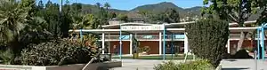
Some residents are assigned to Pacific Palisades Elementary School, some residents are assigned to Canyon Elementary School, and some are assigned to Marquez Elementary School. All residents are zoned to Paul Revere Charter Middle School and Palisades Charter High School.[52][53]
- Marquez Elementary School opened in 1955.[56]

- Paul Revere Middle School first opened as Palisades-Brentwood Junior High School on September 12, 1955; it chose its current name during its first year of operation. It became an internal charter in 1994.[57]
- Palisades Charter High School opened in 1961.[58] Palisades received a charter in 1994.[59]
Private schools in the area include:
- Calvary Christian (K–8)[60]
- Village School[61] (pre-K–6)
- Corpus Christi (K–8)
- St. Matthew's Parish School (PS–8)
- Seven Arrows (K–6)[62]
- Westside Waldorf (K–8)
- Lycée Français de Los Angeles Pacific Palisades Campus[63]
Public libraries
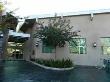
Los Angeles Public Library operates the Palisades Branch at 861 Alma Real Drive.[64]
Media
- The Los Angeles Times is the citywide newspaper.
- The Palisadian-Post, founded in 1928, is the oldest newspaper to serve the Pacific Palisades community.
- The Palisades News, first published in 2014, is a Palisades-based newspaper published twice monthly for the residents of Pacific Palisades.[65]
Landmarks
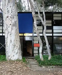
- Eames House: The 1949 home and studio of husband-and-wife design pioneers Charles and Ray Eames.
- The Getty Villa: An educational center and museum dedicated to the study of the arts and cultures of ancient Greece, Rome, and Etruria.
- Villa Aurora: An artists residence and historic landmark located in the former home of exiled German-Jewish writer Lion Feuchtwanger and his wife Marta.
- Thomas Mann House: Thomas Mann's home during his exile from 1942 to 1952 designed by JR Davidson.
- Self-Realization Fellowship Lake Shrine:[12] A 10-acre (4-hectare) spiritual center on Sunset Boulevard founded in 1950 by Paramahansa Yogananda, whose classic book “Autobiography of a Yogi” introduced many Westerners to yoga and Eastern mysticism.
In popular culture
- Jerry Lewis lived in Pacific Palisades on Amalfi Drive during the 1950s. He shot several Gar-Ron Productions home movies at that house with neighbors Tony Curtis and Janet Leigh.[66] He became the honorary mayor of the Palisades in 1953.[67]
- The Beach Boys 1963 hit "Surfin' U.S.A." mentions Pacific Palisades in its list of Southern California surf spots.
- The 1976 book, What Really Happened to the Class of '65? is about members of one of Palisades High School's early graduating classes and how their once-privileged lives turned out years later, often disastrously. The book, by author David Wallechinsky, the son of novelist Irving Wallace, and his "Pali" classmate, film critic Michael Medved, described Pacific Palisades as a microcosm of America during the tumultuous Summer of Love era.[68]
- The West Coast Avengers, a California-based branch of the Marvel Comics superhero team, were depicted as based out of an estate in Pacific Palisades.[69]
- Pacific Palisades, a 1997 TV series produced by Aaron Spelling, was named after the area.
- The characters on the teen show Saved by the Bell (1989–1993) mention on several occasions that their school is located in Pacific Palisades.
- Popular show 90210 mentions Palisades High as their rivals and has filmed some episodes on the beach and at a local restaurant, Cafe Vida.
- British alternative rock band Ash included a song entitled "Pacific Palisades" on their 2001 album Free All Angels.
- Rapper Childish Gambino mentions Pacific Palisades in his song IV. Sweatpants saying, "got a glass house in the Palisades."
- In Modern Family, the Dunphy children attend Palisades Charter High School. Alex Dunphy was crowned school valedictorian in the episode "Patriot Games."
- The main character of the TV series Transparent lives in a house in Pacific Palisades.
- untitled 02 – 06.23.2014., the second track of Kendrick Lamar's 2016 compilation album untitled unmastered, mentions the area in the third verse: "Palisade views with some sex."
Filming locations
- The 1985 Jack Nicholson, Kathleen Turner film Prizzi's Honor was partly filmed at a private house located at 15025 Corona Del Mar, which was repainted for the occasion and then turned back to its original colours after the shooting. That house was demolished later and now only exists in film history. It belonged to Joyce R. Proctor.
- The 2005 Anne Hathaway, Bijou Phillips film Havoc was set in the Palisades and filmed at Palisades Charter High School.
- The 2003 Disney film Freaky Friday with Jamie Lee Curtis and Lindsay Lohan was filmed at Palisades Charter High School.
- The 2001 film Crazy/Beautiful starring Kirsten Dunst was filmed at Palisades Charter High School.
- The house used for the exterior shots of the Pearson residence in the 1979 film Phantasm is located at 1232 Corsica Drive in Pacific Palisades.
- The 1985 music video for "Slip It In" by the hardcore punk band Black Flag was filmed at Palisades High School.
- The 1977 NBC television program James at 16, starring Lance Kerwin, was filmed at the same school, which was then called Palisades High School, or more commonly "Pali High".
- The 1976 film Carrie was filmed at Palisades High School.
- The 1957 film No Down Payment has several sequences around Pacific Palisades posing as a Los Angeles suburb.
- Food Network's Everyday Italian is filmed on El Medio.
- The TV series Baywatch was filmed at Lifeguard Headquarters by tower 15 of Will Rogers State Beach in Pacific Palisades.
- The TV series The Rockford Files was often filmed in and around the Palisades in the 1970s.
- The TV series Popular filmed at Palisades Charter High School
- The TV series Modern Family filmed some scenes at Palisades Charter High School.
- The first-season residence of the television series The Golden Girls was a home in Pacific Palisades. For subsequent seasons, a facade house was built on the Disney/MGM back lot.[70]
- The HBO series Curb Your Enthusiasm is filmed in the real-life Pacific Palisades residence of Larry David, as the home of his character, "Larry David".
- The TV series Teen Wolf was filmed at Palisades Charter High School.
- The original 2014 movie God's Not Dead had scenes filmed at 1033 Ravoli Drive in Pacific Palisades.
- The 2014 movie Redeemed, starring Pacific Palisades resident Ted McGinley, also was filmed at 1033 Ravoli Drive.
- An episode of HBO's Silicon Valley was filmed in the Palisades Highlands at 1268 Piedra Morada Drive. It was used as the home of “Big Head” after he became rich.
- The 2018 movie Dude was filmed at Palisades Charter High School.
Notable people
See also
- List of districts and neighborhoods of Los Angeles
- Old Santa Monica Forestry Station in Pacific Palisades.
References
- "Temescal Gateway Park". MRCA. Retrieved 2020-11-30.
- "NativeLand.ca - Chumash". Native-land.ca - Our home on native land. Retrieved 2020-11-30.
- "TRIBAL CULTURAL RESOURCES ASSESSMENT FOR THE 17346 SUNSET BOULEVARD PROJECT, CITY OF LOS ANGELES, CALIFORNIA" (PDF). LA City.
- "Plaque Commemorating the Ysidro Reyes Adobe". Santa Monica History Museum.
- "Ysidro Reyes, half-owner of Rancho Boca de Santa Monica and descendant of Juan Francisco Reyes, circa 1853-1861". UCLA Library Digital Collections.
- "Photograph of 1890s drawing of Ysidro Reyes adobe, Santa Monica, 1939". UCLA Library.
- "Dedication of the Ysidro Reyes Family plaque at Pampas Ricas and Sunset Blvd., September 14, 1952". Calisphere. Retrieved 2020-11-30.
- Ingersoll, Luther A. (2007). Ingersoll's century history, santa monica bay cities - prefaced with a brief. [Place of publication not identified]: Read Books. ISBN 1-4086-2367-6. OCLC 946583429.
- Loomis, Jan (2009). Pacific Palisades. Arcadia Publishing. ISBN 9780738569482.
- David Laskin (October 3, 2008), When Weimar Luminaries Went West Coast New York Times.
- "Feuchtwanger Memorial Library – Researching German Exiles". usc.edu.
- Finn-Olaf Jonas (November 25, 2007), A Scenic Los Angeles Enclave, Without Glitter New York Times.
- Waldie, D. J. (April 5, 2017). "TED Talks of the Late 1800s: When the Chautauqua Movement Came to California". KCET. Retrieved 29 January 2019.
- Vincent, Roger (March 13, 2018). "Amazon Books heading to Pacific Palisades as new village center takes shape". Los Angeles Times. Retrieved 30 March 2018.
- "The Summit at Palisades Highlands - Welcome to The Summit!". www.palisadessummit.com. Retrieved 2021-01-09.
- California, California State Parks, State of. "Will Rogers SHP". CA State Parks.
- http://la24-prod.s3.amazonaws.com/assets/pdf/LA2024-canditature-part2_english.pdf
- "Pacific Palisades" entry on the Los Angeles Times "Mapping L.A." website
- "Palisades Park Archived 2016-02-07 at the Wayback Machine." Los Angeles Department of Recreation and Parks. Retrieved on November 29, 2008.
- "Palisades Recreation Center." Los Angeles Department of Recreation and Parks. Retrieved on November 29, 2008.
- "Pacific Palisades Tennis Court." Los Angeles Department of Recreation and Parks. Retrieved on November 29, 2008.
- "Rustic Canyon Park." Los Angeles Department of Recreation and Parks. Retrieved on November 29, 2008.
- "Rustic Canyon Pool." Los Angeles Department of Recreation and Parks. Retrieved on November 29, 2008.
- "Rustic Canyon Recreation Center." Los Angeles Department of Recreation and Parks. Retrieved on November 29, 2008.
- "Temescal Canyon Park." Los Angeles Department of Recreation and Parks. Retrieved on November 29, 2008.
- "Santa Ynez Canyon Park." Los Angeles Department of Recreation and Parks. Retrieved on November 29, 2008.
- "Rivas Canyon Park." Los Angeles Department of Recreation and Parks. Retrieved on November 29, 2008.
- "" County of Los Angeles Department of Beaches & Harbors. Retrieved on August 13, 2015.
- "." California Department of Parks and Recreation. Retrieved on August 13, 2015.
- "." Santa Monica Mountains Conservancy. Retrieved on August 13, 2015.
- "." California Department of Parks and Recreation. Retrieved on August 13, 2015.
- "Council District 11." City of Los Angeles. Retrieved on August 6, 2013.
- "Fire Station 69." Los Angeles Fire Department. Retrieved on November 26, 2008.
- "Fire Station 23." Los Angeles Fire Department. Retrieved on November 26, 2008.
- "West LA Community Police Station." Los Angeles Police Department. Retrieved on November 26, 2008.
- "Map of 3rd Supervisorial District." Los Angeles County, California. Retrieved on November 28, 2008.
- "About Us." Los Angeles County Department of Health Services. Retrieved on March 18, 2010.
- "Simms/Mann Health and Wellness Center." Los Angeles County Department of Health Services. Retrieved on March 27, 2010.
- District Map. (2017, January 04). Retrieved March 25, 2019, from https://a50.asmdc.org/district-map
- Senate District 26. (2017, October 02). Retrieved March 25, 2019, from https://sd26.senate.ca.gov/district
- https://boe.ca.gov/lawguides/intro/boe-districts.html
- Mike Schaefer (California). (n.d.). Retrieved March 26, 2019, from https://ballotpedia.org/Mike_Schaefer_(California)
- "Ted Lieu Sworn in as Representative of California's 33rd Congressional District". house.gov. 6 January 2015.
- "Our District". house.gov. 4 December 2012.
- "Post Office Location – PACIFIC PALISADES." United States Postal Service. Retrieved on November 26, 2008.
- "Post Office Location – PACIFIC PALISADES." United States Postal Service. Retrieved on November 26, 2008.
- LAPD lapdonline.org
- Board District 4 Map. Los Angeles Unified School District. Retrieved on November 24, 2008.
- "Board Members." Los Angeles Unified School District. https://boe.lausd.net/
- Two LAUSD board members retire, Friedlander wins Shoah scholarship prize." The Jewish Journal. November 12, 2008.
- Gillespie, Danielle. "Revere, PaliHi Show Best API Gains." Palisadian Post. September 11, 2008.
- "Palisades Charter High School Attendance Zone Archived 2011-07-16 at the Wayback Machine." Los Angeles Unified School District. Retrieved on November 27, 2008.
- "Canyon EL." Los Angeles Unified School District. Retrieved on November 27, 2008.
- "Pacific Palisades EL." Los Angeles Unified School District. Retrieved on November 27, 2008.
- "Marquez EL." Los Angeles Unified School District. Retrieved on November 27, 2008.
- Paul Revere History. (n.d.). Retrieved June 30, 2017, from https://web.archive.org/web/20170630144853/https://www.paulreverems.com/domain/6 Archived from the original
- "Palisades CHTR HS." Los Angeles Unified School District. Retrieved on November 27, 2008.
- "School Profile." Palisades Charter High School. Retrieved on November 27, 2008.
- "Calvary Christian School – Independent, Private Christian School | West Los Angeles, CA". Calvarychristian.org. Retrieved 2015-07-31.
- "Home". Village School. Retrieved 2015-07-31.
- "Seven Arrows". Seven Arrows. Retrieved 2015-07-31.
- "Pacific Palisades Campus Archived 2015-07-01 at the Wayback Machine." Lycée Français de Los Angeles. Retrieved on June 28, 2015.
- "Palisades Branch Library." Los Angeles Public Library. Retrieved on November 26, 2008.
- http://www.palisadesnews.com/index.php/about-us/
- "Home Movies and More from the Jerry Lewis Collection at the Library of Congress". MoMA. Retrieved 6 March 2019.
- Meyer, Matthew. "Former Palisadian Mayor Jerry Lewis Dies at 91". Palisadian-Post. Palisadian-Post. Retrieved 6 March 2019.
- SIMROSS, LYNN (June 30, 1985). "Script Has Changed-What Really Happened to That Golden Class of '65". Los Angeles Times. p. 1.
- Avengers West Coast vol. 1 # 1, cover date September 1984
- "The Golden Girls (1985–1992) : Trivia". Retrieved 2015-07-31.
Further reading
- Young, Betty Lou, Pacific Palisades: Where the Mountains Meet the Sea , Pacific Palisades Historical Society Press (1983)
External links
| Wikimedia Commons has media related to Pacific Palisades, Los Angeles. |
| Wikivoyage has a travel guide for Pacific Palisades. |
Places adjacent to Pacific Palisades, Los Angeles | |
|---|---|
Westside region, Los Angeles | ||
|---|---|---|
| Districts and neighborhoods |
|  |
| Points of interest | ||
| Neighboring cities and communities | ||
| By topic |  | |
|---|---|---|
| Government | ||
| Authority control |
|---|