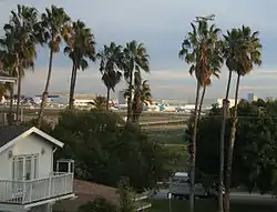
Playa del Rey, Los Angeles
Playa del Rey (Spanish for "the King's beach") is a neighborhood in the South Bay region of the City of Los Angeles, California. It has a ZIP code of 90293 and area codes of 310 and 424. As of 2018, the community had a population of 16,230 people.
Playa del Rey
Palisades Del Rey | |
|---|---|
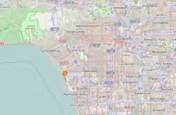 | |
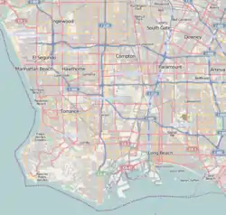 Playa del Rey Location within Southern Los Angeles 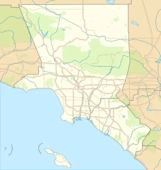 Playa del Rey Location within the Los Angeles metropolitan area  Playa del Rey Location within California  Playa del Rey Location within the United States | |
| Coordinates: 33.958926°N 118.448436°W | |
| Country | |
| State | |
| County | Los Angeles |
| City | Los Angeles |
Geography
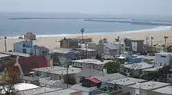
Playa del Rey is a coastal neighborhood and a district of the city of Los Angeles. It is peripherally located, south and west of the heart of Silicon Beach.[1] Its location immediately north of LAX exposes some residents to air and noise pollution generated at the airport. Expansions at the airport have forced more than a thousand residents to move and hundreds of houses to be demolished.
The city of Los Angeles has three small parks in Playa del Rey: Del Rey Lagoon Park, Titmouse Park, and Vista Del Mar Park. Del Rey Lagoon Park has an area of about 70,000 m2, it has a shallow saltwater swamp-pond (known as “Del Rey Lagoon”). The pond has a area of 20,000 m2, with a maximal depth of about 5 feet. Del Rey lagoon’s depth varies over time of day, as The lagoon is partially connected with the Ballona Creek by an underground pipe. To the north of the park is Ballona Creek, to the south Convoy St, to the west is Pacific ave, to the east lies Esplanade and an apartment complex.
The rolling hills and depression wetland ponds are the result of ancient, wind-blown, compacted sand dunes which rise up to 125 feet (38 m) above sea level, originally called and often referred to as The Del Rey Hills or "The Bluffs". These dunes run parallel to the coastline, from Playa del Rey, all the way south to Palos Verdes.
The neighborhood has its own street grid.
The community is bordered by the Pacific Ocean to the west, Marina del Rey and Ballona Creek[2] to the north, Ballona Wetlands and Playa Vista to the northeast, Westchester to the east, and Los Angeles International Airport and El Segundo to the south.
History
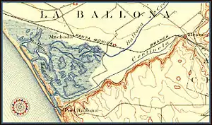
Lower Playa del Rey was originally wetlands and sand dune soil, but natural flooding was halted by levees made of earthen soil, boulders and reinforced concrete with a soft-bottom submerged soil which promotes both tidal flow in good weather and facilitated the flow of freshwater into the ocean in rainy weather resulting in a dynamic estuarine river known as Ballona Creek.
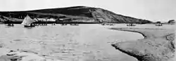
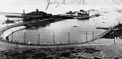
In the 1870s, Playa Del Rey was the location of the first attempt at a dredged harbor in Santa Monica Bay. Under contract with the Atchison, Topeka & Santa Fe Railroad, Moye Wicks' syndicate spent $300,000 to dredge "Port Ballona Harbor", for shipping to the Orient. Within three years, winter waves brought flooding, but what remained of man's early efforts became the Playa Del Rey Lagoon, now a regional public park.[3]
Palisades del Rey (also, Palisades Del Rey) was the name of the original 1921 neighborhood land development by Dickinson & Gillespie Co. that later came to be called Playa del Rey. The company advertised this area of sand dunes as the last stretch of coastal land in the city of Los Angeles to be developed.[4] All of the houses in this area were custom built, many as beach homes owned by Hollywood actors and producers, including Cecil B. Demille, Charles Bickford, and others.
Construction in Playa del Rey surged in 1928 with the development of the Del Rey Hills neighborhood in the Eastern part of the community (to the East of Pershing Drive), and the move of Loyola University (now Loyola Marymount University) to the adjacent community of Westchester.
The southern portion of the original Playa del Rey development, which came to be known as "Surfridge," is now vacant. Between 1966 and 1975 the houses that were once there were either moved or demolished to facilitate the expansion of Los Angeles International Airport (LAX) and to address concerns about the noise of increasing jet plane traffic. The noise from the flights made it less desirable to live on the dunes above the ocean under the LAX flight path. The City of Los Angeles condemned the southern section of Playa del Rey under the power of eminent domain, and purchased all of the homes.[5] Today one can see only barbed-wire fences protecting vacant land and old streets where houses once sat. Recent LAX rejuvenation plans call for the city to finally remove the old streets that still line the empty neighborhood. The condemned areas of the community are now a protected habitat of the endangered El Segundo blue butterfly.[6]
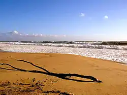
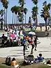
Playa del Rey in the 1950s and early 1960s was known as a great Los Angeles area "surfing spot", but due to the many rock jetties that were built to prevent beach erosion, the good surf has mostly disappeared. The beach at the northernmost end of Playa del Rey is still known as "Toes Over Beach", "Toes Beach" or just "Toes" by the local surfing community, a name derived from the toes over or Hang Ten surfing maneuver. Most surfers now flock south of Dockweiler Beach to "El Porto" (the northernmost part of beach in the city of Manhattan Beach) or north of Marina del Rey to Venice Beach. The lifeguard and park services are uniform across the entire twenty-mile stretch of beach.[7]
One danger for beachgoers is the uncontrolled water runoff from the creek, and the occasional emergency overflow from the giant Hyperion treatment plant to the south.[8] Under normal conditions, the plant discharges treated water five miles out to sea, but a rarely-used one mile outflow pipe exists for emergencies or during maintenance. Wastewater discharged from this shorter pipe is close enough to shore to severely impact beach conditions when it is in use.
Locals refer to the small area of housing closest to the beach, where Culver Boulevard joins Vista del Mar, as The Jungle, a nickname given to a group of closely built apartments built in 1956, bounded by Trolley Place and Trolleyway Street on its east and west respectively, and including the streets Fowling, Rees, Sunridge and Surf. The small sidewalks between homes had/have deep green overgrowth, which added to the name.
Today a bridge between Playa Del Rey and the jetty between Ballona Creek and the Marina is accessible to foot traffic and bicycle traffic, but not to automobiles. Bikers, skaters and joggers can cross this bridge to continue north to Santa Monica, and to the South Bay. It is the only pedestrian crossing over Ballona Creek between the ocean and Centinela Avenue, and the Lincoln Boulevard and SR90 bridges both lack sidewalks. Both UCLA and LMU have crew teams that practice on the Ballona Creek channel and Marina del Rey.[9]
Demographics
According to data from the Los Angeles Times's "Mapping L.A." project, the area's demography was 72.6% Non-Hispanic White, 7.7% Asian, 3.9% Black, 10.0% Latino and 5.8% of other backgrounds.[10]
94.73% of employed Playa Del Rey residents work in a white collar profession. 65.56% of all residents 25 years of age or older have at least a bachelor's degree, and 39.75% of residents have obtained a graduate level education or more. The average household income is $139,737, which is among the wealthiest in Los Angeles.[11]
Economy
As Playa del Rey is located in the heart of the Silicon Beach, the economy has become largely driven by the tech sector. The neighborhood is also home to a large number of airline and aerospace employees owing to its proximity to LAX. The vast majority of land in Playa del Rey is zoned for residential purposes only. It is known for its large ocean-view estates, but the bulk of the population lives in the eastern portion, which is densely developed with apartment and condominium complexes. Only portions of Manchester Avenue, Pershing Drive and Culver Boulevard have businesses—mainly restaurants and a pharmacy—and offices mixed in with residential buildings.
Government and infrastructure
Los Angeles Fire Department Station 5 (Westchester/LAX Area) is in the area.
Los Angeles Police Department operates the Pacific Community Police Station at 12312 Culver Boulevard, 90066, serving the neighborhood.[12]
The Los Angeles County Department of Health Services SPA 5 West Area Health Office serves Playa del Rey.[13]
Playa del Rey lies entirely within the 11th council district of Los Angeles, and is represented on the city council by Mike Bonin.
Education
Playa del Rey is within the Los Angeles Unified School District. The area is within Board District 4.[14] As of 2009 Steve Zimmer represents the district.[15]
Area schools include
- Paseo del Rey Natural Science Magnet (K-5)
- Choice of Loyola Village Elementary School or Kentwood Elementary School and (1–5)
- Orville Wright Middle School (6–8)
- Westchester High School (9–12)
- St. Bernard High School is a private Roman Catholic school in the area.
- Del Rey Christian Children's Center is a private Christian preschool.
As of 2014, the Wiseburn School District allows parents in Playa del Rey to send their children to Wiseburn schools on inter-district transfers.[16]
Notable people
- Roseanne Barr, actress, comedian, former Presidential candidate
- Charles Bickford, film and TV actor, primarily in the 1940s-1950s[17]
- Mel Blanc, voice actor, comedian, and musician. In the 1940s he resided on Ellen Avenue, now absorbed by LAX.
- Jerry Buss, former owner of the Los Angeles Lakers
- Jamaal Wilkes, UCLA and Los Angeles Lakers Hall of Famer
- Bruce Campbell, actor
- William J. Dodd, architect
- Dave Draper, bodybuilder and television host
- Richard Duarte, foley mixer at Fox
- Sam Elliott, actor
- Anthony Michael Hall, actor
- Phil Jackson, former coach of the Los Angeles Lakers[18]
- Anissa Jones, actress
- Noel Jones, bishop
- Jack Kruschen, actor
- Patrick Long, racing driver
- Benny Mardones, singer/songwriter
- William C. deMille, film director
- Sugar Shane Mosley, former World Champion boxer, recently purchased two homes overlooking the beach.
- Lenda Murray, IFBB professional bodybuilder
- Taylour Paige, dancer and actress
- Tara Reid, actress and pop culture figure
- Dawn Robinson, original member of the group En Vogue
- Carroll Shelby, auto designer
- Carmen Twillie, actress/singer
- Donda West, late mother of hip-hop artist Kanye West[19]
References
- https://www.builtinla.com/2018/03/26/silicon-beach-guide-tech-scene
- http://www.ballonacreek.org/index.php/about-ballona-creek/a-short-history
- Del Rey Lagoon, LA Parks.org *ADDRESS: 6660 Esplanade Place, Playa Del Rey, CA 90293 *REGION: Pacific *COUNCIL DISTRICT: 11 *NEIGHBORHOOD SERVICE AREA: West Los Angeles
- Del Rey Hills (now Playa del Rey) 1928 - Los Angeles, California Scripophily.net
- The Argonaut: Top Stories
- Mattoni, Rudolf H. T., "The Endangered El Segundo Blue Butterfly," The Journal of Research on the Lepidoptera, Volume 29 (4), Winter 1990. PDF 19.5 MB Archived 2003-10-25 at the Wayback Machine
- Los Angeles county fire department provides the lifeguards. —Episode #1 LA County Ocean Lifeguards
- KABC (September 24, 2015). "Dockweiler State Beach closed after tampon applicators, condoms, needles wash ashore". ABC7 Los Angeles. Retrieved 2020-10-21.
- "The UCLA Rowing Camp uses the same facilities as the Bruin Rowers, including the UCLA Boathouse in Marina del Rey. "—2017 UCLA Rowing camp
- "Playa del Rey" entry on the Los Angeles Times "Mapping L.A." website
- "Playa Del Rey Population & Demographics, Median Income - Point2". www.point2homes.com. Retrieved 2020-06-06.
- "Pacific Community Police Station - Los Angeles Police Department". www.lapdonline.org. Retrieved 2020-06-06.
- "About Us." Los Angeles County Department of Health Services. Retrieved on March 18, 2010.
- Board District 4 Map. Los Angeles Unified School District. Retrieved on November 24, 2008.
- "Board Members." Los Angeles Unified School District. Retrieved on September 16, 2009.
- "Home" (Archive). Wiseburn School District. Retrieved on April 4, 2014. "Also serving the children of employees from the surrounding aerospace, technology, travel, and entertainment industries, as well as families living in the Westchester, Playa del Rey, Playa Vista, Mar Vista, and Ladera Heights area on an interdistrict permit transfer."
- Film Stars of Playa Del Rey; Charles Bickford, by Duke Dukesherer, Examiner.com.
- Ding, Kevin. "News: Jackson accepts Lakers extension." The Orange County Register. Friday November 30, 2007. Retrieved on June 13, 2009.
- "Donda West dies at 58; local resident and mother of hip-hop artist Kanye West Archived 2012-04-20 at the Wayback Machine." The Argonaut. November 15, 2007. Retrieved on June 13, 2009.
Further reading
- "Playa del Rey: Speed Capital of the World, The Los(t) Angeles Motordrome, 1910-1913" by John Crosse
- http://socalarchhistory.blogspot.com/2011/03/first-board-track-opened-at-los-angeles.html
- Beach Of The King: The Early History of Playa Del Rey, Westchester, Playa Vista, California by D J Dukesherer.
- Playa Del Rey: California by D J Dukesherer.
- T.O. McCoye's Playa Del Rey by Arthur Bradley Fowler
External links
| Wikivoyage has a travel guide for Playa del Rey. |
- http://socalarchhistory.blogspot.com/2011/03/first-board-track-opened-at-los-angeles.html
- Video: Surfridge and Palisades Del Rey - What Remains
- Video: Drone video of Playa del Rey as Jason Bourne trailer spoof
- Surfridge: A Los Angeles' Ghost Town. Photos of the condemned area of Playa del Rey.
| By topic |  | |
|---|---|---|
| Government | ||
Westside region, Los Angeles | ||
|---|---|---|
| Districts and neighborhoods |
|  |
| Points of interest | ||
| Neighboring cities and communities | ||