Delmar Township, Tioga County, Pennsylvania
Delmar Township is a township in Tioga County, Pennsylvania, in the United States. The population was 2,856 at the 2010 census.[4]
Delmar Township, Pennsylvania | |
|---|---|
Township | |
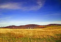 A farm in Delmar Township | |
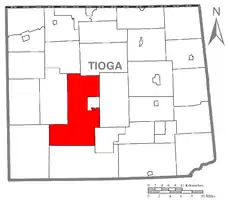 Map of Tioga County Highlighting Delmar Township | |
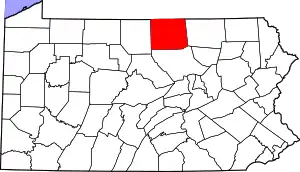 Map of Pennsylvania highlighting Tioga County | |
| Country | United States |
| State | Pennsylvania |
| County | Tioga |
| Settled | 1802 |
| Incorporated | 1805 |
| Area | |
| • Total | 82.40 sq mi (213.42 km2) |
| • Land | 82.23 sq mi (212.98 km2) |
| • Water | 0.17 sq mi (0.44 km2) |
| Population (2010) | |
| • Total | 2,856 |
| • Estimate (2016)[2] | 2,843 |
| • Density | 34.57/sq mi (13.35/km2) |
| Time zone | Eastern Time Zone (North America) |
| • Summer (DST) | EDT |
| FIPS code | 42-117-18760 |
| Historical population | |||
|---|---|---|---|
| Census | Pop. | %± | |
| 2000 | 2,893 | — | |
| 2010 | 2,856 | −1.3% | |
| 2016 (est.) | 2,843 | [2] | −0.5% |
| U.S. Decennial Census[3] | |||
Geography
According to the United States Census Bureau, the township has a total area of 80.6 square miles (209 km2), of which, 80.4 square miles (208 km2) of it is land and 0.2 square miles (0.52 km2) of it (0.20%) is water.
Delmar Township is bordered by Chatham and Middlebury Townships to the north, Charleston Township to the east, Duncan Township to the south and east, Morris Township to the south, Elk Township to the west and Shippen Township to the north and west. Delmar Township forms the northern, western, and southern borders of the borough of Wellsboro.
Demographics
As of the census[5] of 2000, there were 2,893 people, 1,092 households, and 855 families residing in the township. The population density was 36.0 people per square mile (13.9/km2). There were 1,385 housing units at an average density of 17.2/sq mi (6.7/km2). The racial makeup of the township was 98.79% White, 0.35% African American, 0.28% Native American, 0.10% Asian, 0.10% from other races, and 0.38% from two or more races. Hispanic or Latino of any race were 0.28% of the population.
There were 1,092 households, out of which 34.5% had children under the age of 18 living with them, 67.2% were married couples living together, 8.4% had a female householder with no husband present, and 21.7% were non-families. 18.5% of all households were made up of individuals, and 6.3% had someone living alone who was 65 years of age or older. The average household size was 2.64 and the average family size was 3.00.
In the township the population was spread out, with 26.1% under the age of 18, 6.6% from 18 to 24, 27.0% from 25 to 44, 27.4% from 45 to 64, and 12.9% who were 65 years of age or older. The median age was 40 years. For every 100 females, there were 97.9 males. For every 100 females age 18 and over, there were 97.7 males.
The median income for a household in the township was $34,712, and the median income for a family was $37,417. Males had a median income of $29,250 versus $20,833 for females. The per capita income for the township was $16,219. About 9.8% of families and 12.0% of the population were below the poverty line, including 17.4% of those under age 18 and 6.4% of those age 65 or over.
Communities and locations
- Dexter – A village on Pennsylvania Route 660 in the western part of the township.
- Draper – A village in the south-central part of the township.
- Heise Run – A village on U.S. Route 6 in the northern part of the township.
- Kennedy – A village in the southwest part of the township.
- Knapp – A village on Pennsylvania Route 287 in the southeast part of the township.
- Lake Nessmuk – A small lake along Pennsylvania Route 287 just south of Wellsboro.
- Olmsville – A village in the southern part of the township, just west of Draper.
- Stokesdale – A village on U.S. Route 6, about two miles north of Wellsboro.
- Stony Fork – A village in the south-central part of the township, slightly north of Draper.
- Sweetbriar – A village on Pennsylvania Route 287 in the southeast corner of the township.
- Thumptown – A village on Pennsylvania Route 660 near the western township line.
- Tiadaghton – A village in the southwest corner of the township near the Pine Creek Gorge.
- Tioga State Forest – The Tioga State Forest covers much of northwestern Delmar Township.
- Wellsboro – A borough in the eastern part of the township, located at the junctions of Pennsylvania Route 660, Pennsylvania Route 287, and U.S. Route 6. It is the county seat of Tioga County.
- Wellsboro Junction – A village on the Wellsboro and Corning Railroad, about a mile north of Stokesdale.
Education
Residents of Delmar Township may attend the local, public schools operated by Wellsboro Area School District which provides full day kindergarten through 12th grade. In 2013, the District's enrollment declined to 1,526 students in kindergarten through 12th grade. In 2013, Wellsboro Area School District ranked 311th out of 498 public schools for academic achievement of its pupils, by the Pittsburgh Business Times.[6]
Delmar Township residents may also apply to attend any of the Commonwealth's 14 public cyber charter schools (in 2013) at no additional cost to the parents. The resident's public school district is required to pay the charter school and cyber charter school tuition for residents who attend these public schools.[7][8] By Commonwealth law, if the District provides transportation for its own students, then the District must provide transportation to any school that lies within 10 miles of its borders. Residents may also seek admission for their school aged child to any other public school district. When accepted for admission, the student's parents are responsible for paying an annual tuition fee set by the Pennsylvania Department of Education. In 2012, the tuition fees for Wellsboro Area School District were: Elementary School - $8,343.38, High School - $9,951.51.[9]
BLaST Intermediate Unit #17 provides a wide variety of services to children living in its region which includes Delmar Township. Early screening, special educations services, speech and hearing therapy and many other services like driver education are available. Services for children during the preschool years are provided without cost to their families when the child is determined to meet eligibility requirements.
Community members have access to the Green Free Library in Wellsboro; the Westfield Public Library which is located on Maple Street, in Westfield; the Elkland Area Community Library located on East Parkway Avenue, in Elkland and to the statewide PA Power Library which is an online library funded with tax dollars from the state's education budget.
References
- "2016 U.S. Gazetteer Files". United States Census Bureau. Retrieved Aug 14, 2017.
- "Population and Housing Unit Estimates". Retrieved June 9, 2017.
- "Census of Population and Housing". Census.gov. Retrieved June 4, 2016.
- "U.S. Census website". United States Census Bureau. Retrieved 2017-02-27.
- "U.S. Census website". United States Census Bureau. Retrieved 2008-01-31.
- Pittsburgh Business Times (April 5, 2013). "Guide to Pennsylvania Schools Statewide ranking 2013".
- Pennsylvania Department of Education (2013). "Charter Schools".
- Pennsylvania Department of Education (2013). "What is a Charter School?".
- Pennsylvania Department of Education (May 2012). "Pennsylvania Public School District Tuition Rates".
Municipalities and communities of Tioga County, Pennsylvania, United States | ||
|---|---|---|
| Boroughs | | |
| Townships | ||
| CDPs | ||
| Unincorporated communities | ||
| ||