Tioga County, Pennsylvania
Tioga County is a county located on the central northern border of the U.S. state of Pennsylvania. As of the 2010 census, the population was 41,981.[1] Its county seat is Wellsboro.[2] The county was created on March 26, 1804, from part of Lycoming County[3] and later organized in 1812.[4] It is named for the Tioga River.
Tioga County | |
|---|---|
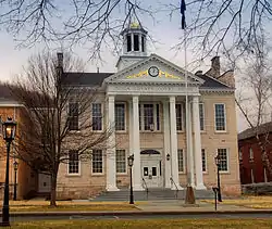 Tioga County Courthouse | |
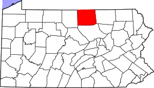 Location within the U.S. state of Pennsylvania | |
 Pennsylvania's location within the U.S. | |
| Coordinates: 41°46′N 77°15′W | |
| Country | |
| State | |
| Founded | October 13, 1812 |
| Named for | Tioga River |
| Seat | Wellsboro |
| Largest borough | Mansfield |
| Area | |
| • Total | 1,137 sq mi (2,940 km2) |
| • Land | 1,134 sq mi (2,940 km2) |
| • Water | 3.2 sq mi (8 km2) 0.3%% |
| Population | |
| • Estimate (2018) | 40,763 |
| • Density | 37/sq mi (14/km2) |
| Time zone | UTC−5 (Eastern) |
| • Summer (DST) | UTC−4 (EDT) |
| Congressional district | 12th |
| Website | www |
History
The county was originally settled by migrants of "Yankee" stock (migrants from New England and the western part of New York who were descended from the English Puritans of colonial New England). With the opening of a rough wagon road to the source of the Tioga River, New England settlers poured over the Allegheny Mountains. Tioga County resembled upstate New York more than it did eastern Pennsylvania, as its population primarily consisted of settlers from New England.[5] Developers and land speculators laid out roads, established post routes, erected public buildings erected and people were invited to move there. The original settlers were entirely of New England origins or were Yankees from upstate New York, whose families had recent ancestors in New England, with migration taking place in the aftermath of the Revolutionary War. Tioga County was largely culturally contiguous with New England culture, which was influential across the Northern Tier of the United States through its migrants.
In the late 19th and early 20th centuries, the county accepted more immigrants from Ireland, Germany and eastern Europe, who came to work in the coal mines. A number of them were Roman Catholic, introducing more diversity into the mixture of religions here.
Geography
According to the U.S. Census Bureau, the county has a total area of 1,137 square miles (2,940 km2), of which 1,134 square miles (2,940 km2) is land and 3.2 square miles (8.3 km2) (0.3%) is water.[6] It is the fourth-largest county in Pennsylvania by land area and fifth-largest by total area. It has a warm-summer humid continental climate (Dfb) and average monthly temperatures in Wellsboro range from 22.8 °F in January to 68.2 °F in July.
Adjacent counties
- Steuben County, New York (north)
- Chemung County, New York (northeast)
- Bradford County (east)
- Lycoming County (south)
- Potter County (west)
Demographics
| Historical population | |||
|---|---|---|---|
| Census | Pop. | %± | |
| 1810 | 1,687 | — | |
| 1820 | 4,021 | 138.4% | |
| 1830 | 8,978 | 123.3% | |
| 1840 | 15,498 | 72.6% | |
| 1850 | 23,987 | 54.8% | |
| 1860 | 31,044 | 29.4% | |
| 1870 | 35,097 | 13.1% | |
| 1880 | 45,814 | 30.5% | |
| 1890 | 52,313 | 14.2% | |
| 1900 | 49,086 | −6.2% | |
| 1910 | 42,829 | −12.7% | |
| 1920 | 37,118 | −13.3% | |
| 1930 | 31,871 | −14.1% | |
| 1940 | 35,004 | 9.8% | |
| 1950 | 35,474 | 1.3% | |
| 1960 | 36,614 | 3.2% | |
| 1970 | 39,691 | 8.4% | |
| 1980 | 40,973 | 3.2% | |
| 1990 | 41,126 | 0.4% | |
| 2000 | 41,372 | 0.6% | |
| 2010 | 41,981 | 1.5% | |
| 2018 (est.) | 40,763 | [7] | −2.9% |
| U.S. Decennial Census[8] 1790–1960[9] 1900–1990[10] 1990–2000[11] 2010–2017[1] | |||
As of the census[12] of 2000, there were 41,373 people, 15,925 households, and 11,195 families residing in the county. The population density was 36 people per square mile (14/km2). There were 19,893 housing units at an average density of 18 per square mile (7/km2). The racial makeup of the county was 98.11% White, 0.60% Black or African American, 0.23% Native American, 0.30% Asian, 0.01% Pacific Islander, 0.14% from other races, and 0.61% from two or more races. 0.52% of the population were Hispanic or Latino of any race. Residents of Tioga County were of 31.9% English, 23.1% German, 10.1% Irish, 6.0% Polish and 5.3% Italian ancestry.
There were 15,925 households, out of which 30.40% had children under the age of 18 living with them, 57.80% were married couples living together, 8.60% had a female householder with no husband present, and 29.70% were non-families. 24.40% of all households were made up of individuals, and 11.30% had someone living alone who was 65 years of age or older. The average household size was 2.48 and the average family size was 2.93.
In the county, the population was spread out, with 23.70% under the age of 18, 10.60% from 18 to 24, 25.40% from 25 to 44, 24.20% from 45 to 64, and 16.00% who were 65 years of age or older. The median age was 38 years. For every 100 females there were 95.90 males. For every 100 females age 18 and over, there were 92.80 males.
- Live birth rates
Tioga County's live birth rate was 524 births in 1990. The County's live birth rate in 2000 was 475 births, while by 2011 it had declined to 437 babies.[13] Over the past 50 years (1960 to 2010), rural Pennsylvania saw a steady decline in both the number and proportion of residents under 18 years old. In 1960, 1.06 million rural residents, or 35 percent of the rural population, were children.
- County poverty demographics
According to research by The Center for Rural Pennsylvania, which is a legislative Agency of the Pennsylvania General Assembly, the poverty rate for Tioga County was 16.3% in 2014.[14] The statewide poverty rate was 13.6% in 2014. The 2012 childhood poverty rate by school district was: Northern Tioga School District – 44.6% living at 185% or below than the Federal Poverty Level and Southern Tioga School District – 40.6% and Wellsboro Area SD was 31.8%.[15]
Politics and government
| Year | Republican | Democratic | Third parties |
|---|---|---|---|
| 2020 | 74.5% 15,742 | 23.5% 4,955 | 2.0% 429 |
| 2016 | 73.6% 13,614 | 21.1% 3,901 | 5.4% 992 |
| 2012 | 66.4% 11,342 | 31.3% 5,357 | 2.3% 395 |
| 2008 | 62.5% 11,326 | 35.3% 6,390 | 2.3% 410 |
| 2004 | 68.4% 12,019 | 30.9% 5,437 | 0.7% 115 |
| 2000 | 65.2% 9,635 | 31.3% 4,617 | 3.5% 520 |
| 1996 | 51.2% 7,382 | 34.4% 4,961 | 14.4% 2,082 |
| 1992 | 47.3% 7,823 | 29.4% 4,868 | 23.3% 3,852 |
| 1988 | 66.0% 9,471 | 33.5% 4,807 | 0.5% 72 |
| 1984 | 71.9% 10,532 | 27.7% 4,060 | 0.4% 52 |
| 1980 | 63.3% 8,770 | 30.9% 4,273 | 5.8% 806 |
| 1976 | 58.4% 8,417 | 40.2% 5,795 | 1.3% 193 |
| 1972 | 72.1% 10,028 | 26.8% 3,733 | 1.1% 157 |
| 1968 | 67.1% 9,298 | 25.2% 3,488 | 7.8% 1,077 |
| 1964 | 48.7% 7,064 | 51.2% 7,415 | 0.1% 16 |
| 1960 | 73.0% 11,082 | 26.9% 4,076 | 0.1% 15 |
| 1956 | 76.7% 10,827 | 23.2% 3,280 | 0.0% 6 |
| 1952 | 78.7% 11,203 | 21.1% 3,006 | 0.3% 35 |
| 1948 | 77.0% 10,016 | 23.0% 2,986 | |
| 1944 | 75.7% 10,381 | 23.7% 3,248 | 0.6% 79 |
| 1940 | 72.2% 11,645 | 27.5% 4,434 | 0.3% 43 |
| 1936 | 69.4% 12,567 | 30.1% 5,442 | 0.6% 99 |
| 1932 | 75.0% 9,583 | 23.5% 3,004 | 1.5% 191 |
| 1928 | 87.2% 11,774 | 12.5% 1,688 | 0.3% 36 |
| 1924 | 81.2% 8,452 | 12.2% 1,271 | 6.6% 683 |
| 1920 | 83.3% 9,718 | 10.8% 1,258 | 5.9% 693 |
| 1916 | 66.4% 5,347 | 28.5% 2,294 | 5.1% 411 |
| 1912 | 22.4% 1,895 | 22.5% 1,901 | 55.1% 4,662 |
| 1908 | 71.3% 6,947 | 23.8% 2,321 | 4.9% 478 |
| 1904 | 79.3% 7,410 | 16.5% 1,541 | 4.2% 391 |
| 1900 | 71.0% 7,458 | 25.1% 2,638 | 3.9% 406 |
| 1896 | 71.4% 7,922 | 25.5% 2,828 | 3.1% 342 |
| 1892 | 64.8% 6,706 | 28.2% 2,921 | 7.0% 726 |
| 1888 | 69.2% 7,808 | 26.4% 2,972 | 4.4% 499 |
Tioga County is one of the most heavily Republican represented counties in Pennsylvania. This has a long history as Abraham Lincoln reportedly received 78.57% of the county's vote in the 1860 Presidential election.[17] Since Abraham Lincoln the county has voted for the non-Republican presidential candidate only two times. The first was Theodore Roosevelt's 1912 run as a Progressive and the second was Lyndon B. Johnson's landslide in 1964.[18] In 2004, George W. Bush received 12,019 votes (68%) to 5,437 votes (31%) for John Kerry. In 2008 John McCain received 62.7% of the vote.[19] In 2006, Rick Santorum and Lynn Swann both had significant victories in Tioga County despite their defeats statewide. The last two sitting Board of Commissioners have been all Republican candidates, and Tioga County is the only county in Pennsylvania with all three sitting commissioners being from a single party. This was due to the success of write in campaigns conducted by Roger Bunn in 2011 and Mark Hamilton in 2015.
United States senator
- Robert "Bob" P. Casey, Jr (Democrat)
- Patrick "Pat" J. Toomey (Republican)
United States Congress
- Fred Keller (Republican) – 12th Pennsylvania Congressional District (Includes all of Tioga County).
Pennsylvania state senator
Pennsylvania state representative
- Clint Owlett (Republican) – 68th District, Pennsylvania House of Representatives
County commissioners
- Roger C. Bunn, chair (Republican)
- Erick J. Coolidge (Republican)
- Mark L. Hamilton, vice-chair (Republican)
Court of Common Pleas judge, 4th Judicial District of Pennsylvania
- George W. Wheeler (Republican/Democrat)
District attorney
- Krista Deats (Republican)
Register of wills / recorder of deeds
- Jane E. Wetherbee (Republican)
Prothonotary / clerk of courts
- Marie Seymour (Republican)
County treasurer
- Kera Hackett (Republican)
Sheriff
- Frank Levindoski (Republican)
Coroner
- James L. Wilson (Republican)
Auditors
- Rebecca B. Briggs (Republican)
- Elizabeth T. Craig (Republican)
- Amy Kane Perry (Republican)
Marcellus shale impact fee
In March 2012, the Tioga County Commissioners approved a marcellus shale impact fee ordinance.[20] The Commissioners anticipated $5.5 million to $6 million in annual impact fee revenue. In 2012, under Governor Corbett, the Pennsylvania General Assembly passed a bill that authorizes an impact fee be collected on marcellus shale wells. Regulations and processes for distribution of the money are governed by the Pennsylvania Utility Commission (PUC). Annual reports on the number of wells and revenues taken in are made public on the PUC website.[21][22]
In 2016, the Pennsylvania Utility Commission lowered the Impact fee on shale gas wells.[23]
The use of the impact shale fee funds is limited by state law to:[24]
- Emergency preparedness and public safety.
- Road, bridge and infrastructure projects.
- Water, storm water and sewer systems and other environmental projects.
- Records management, IT.
- Tax reductions.
- Preservation and reclamation of surface and subsurface waters and water supplies.
- Projects that increase the availability of affordable housing.
- Delivery of social services.
- Judicial services.
- Career and technical centers for training of workers.
- Career and technological centers for training of workers in the oil and gas industry.
- Local or regional planning initiatives under the Pennsylvania Municipal Planning Code.
In 2014 Tioga County received an impact fee disbursement of $3,593,564.21 which was among the top seven Pennsylvania counties receiving impact funds. In 2014, there were 839 Marcellus shale wells in Tioga County.[25] Statewide the top county recipient was Washington County which received $6,512,570.65 in 2014.[26]
Education
Colleges and universities
- Mansfield University in Mansfield is a member of the Pennsylvania State System of Higher Education.
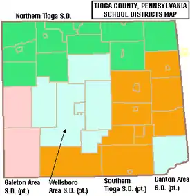
Public school districts
- Canton Area School District (also in Bradford County and Lycoming County)
- Galeton Area School District (also in Potter County)
- Northern Tioga School District
- Southern Tioga School District (also in Lycoming County)
- Wellsboro Area School District
Private schools
As reported by EdNA, Pennsylvania Department of Education, June 2010.
- Covington Community DCC, Covington
- Irvin Comstock Seventh-Day Adventist School, Wellsboro
- Laurel Youth Services, Blossburg
- Lauries Bright Beginnings CCC, Millerton
- Mansfield Area Nursery School, Mansfield
- Maranatha Mission Learning Community Branch 20, Trout Run
- New Covenant Academy, Mansfield
- Presbyterian Child Development Center, Wellsboro
- Stony Fork Mennonite School, Wellsboro
- Trinity Lutheran School, Wellsboro
- Toddler University, Blossburg
- Toddler University, Trinity
- Wellsboro Montessori Children's Center, Wellsboro
- Wesley Academy, Elkland
Public libraries
- Blossburg Memorial Library
- Elkland Area Community Library
- Green Free Library – Wellsboro
- Knoxville Public Library
- Mansfield Free Public Library
- Potter-Tioga County Lib System
- Westfield Public Library
Transportation
Public transportation is provided by BeST Transit.
Recreation
There are three Pennsylvania state parks in Tioga County.
- Hills Creek State Park is several miles north of U.S. Route 6 between Wellsboro and Mansfield in Charleston Township.
- Colton Point State Park and Leonard Harrison State Park are both part of the Pennsylvania Grand Canyon that is carved by Pine Creek.
Communities
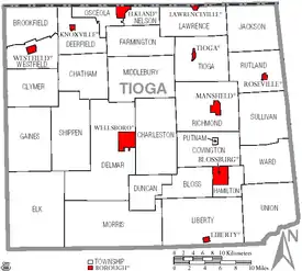
Under Pennsylvania law, there are four types of incorporated municipalities: cities, boroughs, townships, and, in at most two cases, towns. The following boroughs and townships are located in Tioga County:
Boroughs
Townships
Census-designated places
Census-designated places are geographical areas designated by the U.S. Census Bureau for the purposes of compiling demographic data. They are not actual jurisdictions under Pennsylvania law. Other unincorporated communities, such as villages, may be listed here as well.
Ghost town
Population ranking
The population ranking of the following table is based on the 2010 census of Tioga County.[30]
† county seat
| Rank | City/Town/etc. | Municipal type | Population (2010 Census) |
|---|---|---|---|
| 1 | Mansfield | Borough | 3,625 |
| 2 | † Wellsboro | Borough | 3,263 |
| 3 | Elkland | Borough | 1,821 |
| 4 | Blossburg | Borough | 1,538 |
| 5 | Westfield | Borough | 1,064 |
| 6 | Tioga | Borough | 666 |
| 7 | Knoxville | Borough | 629 |
| 8 | Lawrenceville | Borough | 581 |
| 9 | Arnot | CDP | 332 |
| 10 | Millerton | CDP | 316 |
| 11 | Liberty | Borough | 249 |
| 12 | Roseville | Borough | 189 |
References
- "State & County QuickFacts". United States Census Bureau. Retrieved November 22, 2013.
- "Find a County". National Association of Counties. Retrieved June 7, 2011.
- An outline history of Tioga and Bradford counties in Pennsylvania, Chemung, Steuben, Tioga, Tompkins and Schuyler in New York: by townships, villages, boro's and cities, John L. Sexton. The Gazette Company, 1885, p3. 1885. p. 3. Retrieved 2010-09-17.
tioga county, pa. sexton.
- "Pennsylvania: Individual County Chronologies". Pennsylvania Atlas of Historical County Boundaries. The Newberry Library. 2008. Retrieved March 13, 2015.
- The Expansion of New England: The Spread of New England Settlement and Institutions to the Mississippi River, 1620–1865, pp. 151-152
- "2010 Census Gazetteer Files". United States Census Bureau. August 22, 2012. Retrieved March 11, 2015.
- "Population and Housing Unit Estimates". Retrieved October 9, 2018.
- "U.S. Decennial Census". United States Census Bureau. Retrieved March 11, 2015.
- "Historical Census Browser". University of Virginia Library. Retrieved March 11, 2015.
- Forstall, Richard L., ed. (March 24, 1995). "Population of Counties by Decennial Census: 1900 to 1990". United States Census Bureau. Retrieved March 11, 2015.
- "Census 2000 PHC-T-4. Ranking Tables for Counties: 1990 and 2000" (PDF). United States Census Bureau. April 2, 2001. Retrieved March 11, 2015.
- "U.S. Census website". United States Census Bureau. Retrieved 2011-05-14.
- Pennsylvania Department of Health, Birth Age County Reports 1990 and 2011, 2011
- US Census Bureau (2015). "Poverty Rates by County Small Area Income and Poverty Estimates".
- Pennsylvania Budget and Policy Center (2012). "Student Poverty Concentration 2012".
- Leip, David. "Dave Leip's Atlas of U.S. Presidential Elections". uselectionatlas.org. Retrieved 3 April 2018.
- "David Leip Presidential Election Atlas for 1860". uselectionatlas.org. Retrieved 3 April 2018.
- "Presidential election of 1912 – Map by counties". geoelections.free.fr. Retrieved 3 April 2018.
- "President Map – Election Results 2008 – The New York Times". elections.nytimes.com. Retrieved 3 April 2018.
- AP The Daily Review, Tioga County Gives Nod To Impact Fee On Gas Drilling, March 15, 2015
- ennsylvania House of Representatives, HB1950 of Session 2011 OIL AND GAS (58 PA.C.S.) – OMNIBUS AMENDMENTS, February 8, 2012
- Pennsylvania Utility Commission (2012). "Act 13 (Impact Fee)".
- Anya Litvak., Pittsburgh Post-Gazette, PUC announces lower impact fee on drillers as natural gas price drops January 29, 2016
- PA General Assembly, Summary of Marcellus Shale Impact Fee Legislation, 2012
- Pennsylvania Utility Commission (2015). "County Well Count Breakdown for 2014".
- Pennsylvania Utility Commission (2015). "Disbursements and Impact Fees 2014".
- PUC (2013). "Tioga County Total distribution for year 2013 :".
- Pennsylvania Budget and Policy Center (April 2014). "Measuring the Costs and Benefits of Natural Gas Development in Tioga County, Pennsylvania: A Case Study" (PDF).
- Dave Warner (October 30, 2014). "They came, they drilled, and for now some have left this Tioga County town". PennLive.com.
- Promotions, Center for New Media and. "US Census Bureau 2010 Census". www.census.gov. Retrieved 3 April 2018.
External links
- Tioga County, Pennsylvania
- Map 562 *Augmented by Williams, J. H., Taylor, L. E., and Low, D. J. (1993), Surficial geologic map of major glaciated valleys of Bradford, Tioga, and Potter Counties, Pennsylvania, showing locations of wells, test holes, and data-collection sites, Pennsylvania Geological Survey, 4th ser., Water Resource Report 68.
Municipalities and communities of Tioga County, Pennsylvania, United States | ||
|---|---|---|
| Boroughs | | |
| Townships | ||
| CDPs | ||
| Unincorporated communities | ||
| ||

| Authority control |
|---|