Dewaitha
Dewaitha (also spelled Devaitha) is a village of Kamsaar in Ghazipur, Uttar Pradesh, India. Dewaitha village is located almost 43 km from the main city of Ghazipur and 394 km (245 mi) from state capital Lucknow. The village is located in the banks of Karmanasa river. It's gram panchayat cantains three villages name as Dewaitha, Ghorohiyan and Karmahari with the total garm panchayaati area of 1,223.15 ha (3,022.5 acres).[2][3][4][5]
Dewaitha
देवाइथा Daudpur | |
|---|---|
Village | |
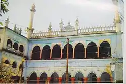 Purani Masjid of Dewaitha build in 1605 by Raja Daud Khan founder of dewaitha, pic of 1982 | |
| Nickname(s): The village of rich | |
 Dewaitha Location in Uttar Pradesh, India | |
| Coordinates: 25.364°N 83.644°E | |
| Country | |
| State | Uttar Pradesh |
| District | Ghazipur |
| Established | 1605 |
| Founded by | Zamindar Daud khan |
| Government | |
| • Type | Panchayati Raj (India) |
| • Body | Gram Pradhan |
| Area | |
| • Total | 442.22 ha (1,092.75 acres) |
| • Land | 427.596 ha (1,056.613 acres) |
| • Water | 14.624 ha (36.137 acres) |
| Dimensions | |
| • Length | 2.67 km (1.66 mi) |
| • Width | 2.15 km (1.34 mi) |
| Elevation | 70 m (230 ft) |
| Population (2011) | |
| • Total | 7,104 |
| • Density | 1,600/km2 (4,200/sq mi) |
| Demonym(s) | Kamsaari |
| Languages | |
| • Official | Bhojpuri, Hindi, Urdu |
| Time zone | UTC+5:30 (IST) |
| PIN | 232326[1] |
| Telephone code | 05497 |
| Vehicle registration | UP 61 |
History
Diwaitha village was established by Diwan-e-ala Jagirdar taluka Daudpur zamindar Raja Daud Khan (b.1585) a great grandson of Narhar Khan (founder of Dildarnagar Kamsar) in September 1605 AD. Daud Khan also built a mosque in the village which is now known as Purani Masjid. The Purani Masjid was the third-largest mosque by area in Kamsar. The mosque campus is spread over one-half acre. When the mosque was built in 1605, its minaret was 62 feet in height which was tallest in Ghazipur and nearby cities and Kamsar. Later the minarets became weak so they were broken and were renovated in the 1890s. Now the minarets are 56 feet in height. When the village was founded it was also known as Daudpur in honour of Raja Daud Khan a Sarkar of and Ghazipur, Ballia, and Mau. The honour to Daud Khan was given by mughal emperor Jahangir in 1630ADs. Daud Khan became a large zamindar and jagirdar of the region. He was made Jagirdar of Ghazipur and Diwan of Bihar Subah in Mughal era by the Mughal emperor Shah jahan after the death of his cousin Raja kuttul Khan who handled the post.[6][7]
Zamindars of Daudpur flourished during the rule of Nawab Sheikh Abdullah (founder of Bahadurgnaj) and his son Fazal Ali Khan, (Nawabs of Ghazipur) it is said that zamindars of Daudpur had a good relationship with Sheikh Abdullah's family. But in 1757, the whole Qasimabad and Kamsar Jagirs fell into the hands of to Banaras estate. But they were not destroyed as the jagir but they were made small. Daudpur jagirs were spread over 68 villages in 1850s.[8]
Dewaitha village became a Gram Panchaayat in year 1959 and Zamindar Muhammad Wasil Khan a grand son of Nawab Amir Khan (younger brother of Nawab Khuda Bhaksh Khan a jagirdar of Daudpur and Kamsar from year 1837–1882) was made the first Pradhan of the village. The Kamsar Jagir was spread over 122 villages in 1840s with total area of 1237.6 km² and was divided into two Parganas name as Daudpur and Seorai . Where Daudpur had 68 villages witch the total area of 265.2 km² and Seorai had 54 chief villages with an total area of 970.41 km². Kamsar Jagir was kept on the revenue demand of ₹ 2.5 Lakh in 1830 per year Khuda Bhaksh khan only got 15% of the total revenue, 25% was use for the mintanence and Salary of the farmers and 60% revenue was given to British. Later in 1952 after the abolishment of Jagirs all the villages were separated and kept on their own revenue demands.During the rule of Khuda Bhaksh Khan the village (Dewaitha) land extended 107.40 km2 in Uttar Pradesh and Bihar and his Daudpur Pargana extended from Dewaitha to Karari village located on the banks of Karmanasa river (Kaimur) and from Zamania to Durgawati river making his Daudpur pargana of area almost 265.2 km2 and another pargana of Kamsar name as Seorai consisting 54 villages. Daudpur pargana was kept on a revenue demand of rupees 72916 by the British government in 1830.When Daudpur Paragana fell into the hands of British in early 1930s and a new Paragana was name as Ramgarh was made because of which many families settled in Ramgarh. Descendants of Khuda Bhaksh Khan's family however, were not able to stop the migration from Daudpur, handle the Daudpur with excellence performance, and save their Kamsar jagir and Daudpur Paragana from other zamindars of the region and British. The Nawab of Ghazipur was also not capable to save the jagir. Before Ramgarh was a very small village belonging to mainly Rajputs were 51.25 km2 of zamindari other than Dewaitha belonged to the family of Ramgarh and other adjoining villages and rest 9.5 km2 to the Kamsar pathans of Fufuao (a relative village of Dewaitha) and 2 km2 to the Thakur familyies of Tiyari. Some zamindari also belonged to Dumri village(a relative village of Dewaitha).[9][8][6][10]
Well still the family of Khuda Bhaksh Khan descendants and relatives held a strong hold on the region till 1952, after the abolishment of Zamindari. Wasil Khan the first pradhan of the village and his elder brother Zamindar Muhammad Nur Khan were also a Lambardar and Chaudhari of 40 villages and Hamlets from 1905 to 1952 came under the area of Dewaitha. At their final extent their Lambardari spread over 252 km2 and had 87 villages on the revenue demand of rupees 78125 in 1910. Where Wasil Khan shown great ability and he was elected as the Pradhan. During early 1900s, Zamindar Inayat Khan was also a Lambardar with them. Inayat Khan was an owner of present-day Kabirpur, Rohura, Udharanpur and some parts of Karmahari village. Inayat Khan was the biggest land owner of Daudpur in later 19th century and early 20th century.[8][11][9][7][10]
Raja Khuda Bhaskh Khan also build a Duwara in Dewaitha name as Khuda Bhaksh Khan ka Darwaza. Khuda Bhaksh Khan also build a monument at Ramgarh (Kaimur) name as Khuda Bhaksh Khan ka Kot who's pucca construction was completed later by his descendants in late 1890s. Kot of Khuda Bhaksh Khan at Ramgarh was later used by Zamindar Nur Khan and his brother for administrative pouposes for some time. After the abolishment of zamindari the family Later family given the Kot to a friend family.(say, 1960s). His family also build a kot in a region (Know zamania station).His ancestors and he made the boundary wall surrounding Athoghar and Kot Mohalla. It is said that there were four gates to enter in Adhoghar and Kot Mohalla where one gate opened on the north side, one south, one east, and one was near the Purani Masjid, where the market of the village was situated. The four gates were made from iron, silver and the handles and decoration were done with gold, the walls were painted with the powder of precious stones. According to the sayings, these four gates had cannons for protection which were later taken by the British government (1940s). There are also some villages and hamlets near Dewaitha which are established in the name of Daud Khan(founder) and his family name as Daudpur, Kdirpur, Kbirpur, Hamidpur, Rustampur, Mahmudpur (know Rasulpur), Kasimpur, (know Karmahari).[9][7][6][8][11][10]
Geography
Dewaitha is on the road joining the Gazipur and Ramgarh districts. The Dewaitha village is located on the banks of the Karamnasa River which passes almost 2 km from the village. Dewaitha has an average annual rainfall of 1155mm, and the village is 70 metres above sea level. Dewaitha village have a total geographical area of 442.22 hectares. Although the family of Dewaitha own land in other villages too. The total land spread of the village is almost 24 km2 .[4][6]
Demographics
The total land spread of the village is 968.2 hectares which contains Four other villages. As of 2011 census of India, the total geographical area of the village is 442.22 hectares. The village has a total population of 7104 and 917 households.[2][5][4]
| 1 | Created as a Gram Pancha yat | 1959 |
| 2 | Total Area (Hectares) | 442.22 |
| 3 | Total Families | 917 |
| 4 | Rural Families | 917 |
| 5 | Literacy | 76% |
| 5.1 | Male literacy | 87.2% |
| 5.2 | Female literacy | 63.88% |
| 6 | Population living in Geographical area | 7104 |
| 6.1 | Male | 3685 |
| 6.2 | Female | 3419 |
| 6.3 | Number if Children | 1131 |
| 6.4 | Number of Schedule cast and tribe | 1228 |
| 7 | Total number of House hold industries | 16 |
| 8 | Total Agricultural Land (Hect.) | 388.84 |
Economy
Local industries include brick manufacturing; cattle, poultry, and fish farming; fertiliser and pesticide manufacture; milling; and agriculture, with a number of crops cultivated. The village contains one post office, State Bank of India and Allahabad Bank automated teller machines.Dildarnagar Junction railway station is the closest railway station, located 7.1 km from the village. Dewaitha has two playgrounds and one Eidgah.[7][11]
Infrastructure
The village main village of Dewaitha is decided into six parts name as Purab Muhallah, Pashim Muhallah, Dakchir Muhallah, Kot Muhallah, Haji Muahllah and Athoghar which are founded by the decedents of Daud Khan. As of 2011 census the main population of the village lived in an area of 132 acres and had 917 households. The village has two English schools, two Urdu medium schools, one government primary school, and one government secondary school. SKBM Degree College which is the nearest degree college of the village is s 8.3 km from the village. The village have four Mosque name as Purani Masjid, Nai Masjid, Abubaqar Siddiq Masjid, and Noori Masjid. All these mosques have their own madarsas. There are five Madarsas in the village, three Temples. The roads of the village are 6–12 feet in breath. The main road of the village is 15 feet wide and is also known as Bazar wali sarak. The bazaar wali sarak has had markets for more than 400 years. Before the market was organized by the Mughal Empire then British and then to the people of the village.[8][4][3][2]
The bazaar wali sarak also holds a gali name as Haluwai gali. It is said that the people of the village before liked sweets a lot so the descendants of Daud Khan brought some famous sweet makers and Sheffs of the region and settled them in the village. The place is also known as Haluwai muhallah. The Haluwai muhallah is very famous for its different variety of Halvas, Curd, Lassi etc. During Mughal and Britsh empire different kinds of sweet dishes and products were sold to Islamabad, Multan, Faisalabad, Peshawar, Lahore, Dhaka, Luckhnow, Delhi, Faizabad, Varanasi, Allahabad, Agra etc. Mostly of the traditional dishes which are transferred from the ancestors of the family were made. The village has four gates to enter. All these gates were made in 1600s; they are 20-foot-tall iron gates which are mostly open. The village also has one imambara, and eid gah. Mostly the old buildings of the village have Mughal architecture. The village also had many havelis made up of Mughal and British architecture during British era. There is also one Ghas bazaar in the village where food is sold for cows and goats.[3][7][11][8][9]
References
- "Pin Code: Dewaitha, Ghazipur, Uttar Pradesh, India, Pincode.net.in". PINCode Search, Post Office Details, All India Post Office Data Pincode.net.in. Retrieved 3 September 2018.
- "Pincode of Dewaitha village in Zamania tehsil pf Ghazipur District".
- "Bhulekh".
- "2011 census of India".
- "Panchyati Raj, Ghazipur".
- "Evolution and spatial organization of clan settlements in middle ganga valley".
- Khan, Suhail. Kamsarnama.
- "Ghazipur Gazeteer".
- "Orissa and bihar Shahabad District gazetteer".
- "Archiological Gazetteer of Kaimur District".
- "Ballia District, Gazetteer".