Djamaa
Djamaa (Arabic: ﺟﺎﻣﻌﺔ) (also written Jama'a[2]) is a town and commune in El Oued Province, Algeria. According to the 2008 census it has a population of 50,916,[1] up from 37,438 in 1998,[2] with an annual growth rate of 3.1%.[1]
Djamaa
ﺟﺎﻣﻌﺔ | |
|---|---|
Commune and town | |
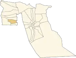 Location of Djamaa commune within El Oued Province | |
 Djamaa Location of Djamaa within Algeria | |
| Coordinates: 33°32′N 6°0′E | |
| Country | |
| Province | El Oued Province |
| District | Djamaa District |
| Elevation | 41 m (135 ft) |
| Population (2008)[1] | |
| • Total | 50,916 |
| Time zone | UTC+1 (CET) |
Geography
To the east of Djamaa is a large area of palm plantations. The locality of Tigdidine lies amongst the palm trees. To the west the landscape is mostly arid and sandy, although there is another smaller palm plantation about 3 kilometres (1.9 mi) west of the town.
Climate
Djamaa has a hot desert climate (Köppen climate classification BWh), with very hot summers and mild winters, and very little precipitation throughout the year.
| Climate data for Djamaa | |||||||||||||
|---|---|---|---|---|---|---|---|---|---|---|---|---|---|
| Month | Jan | Feb | Mar | Apr | May | Jun | Jul | Aug | Sep | Oct | Nov | Dec | Year |
| Average high °C (°F) | 16.8 (62.2) |
19.4 (66.9) |
23.4 (74.1) |
28.0 (82.4) |
33.0 (91.4) |
37.9 (100.2) |
41.5 (106.7) |
40.8 (105.4) |
35.7 (96.3) |
28.9 (84.0) |
21.9 (71.4) |
17.4 (63.3) |
28.7 (83.7) |
| Daily mean °C (°F) | 10.5 (50.9) |
12.9 (55.2) |
16.5 (61.7) |
20.6 (69.1) |
25.4 (77.7) |
30.5 (86.9) |
33.5 (92.3) |
32.9 (91.2) |
28.6 (83.5) |
22.3 (72.1) |
15.6 (60.1) |
11.4 (52.5) |
21.7 (71.1) |
| Average low °C (°F) | 4.2 (39.6) |
6.4 (43.5) |
9.6 (49.3) |
13.2 (55.8) |
17.9 (64.2) |
23.2 (73.8) |
25.5 (77.9) |
25.1 (77.2) |
21.6 (70.9) |
15.7 (60.3) |
9.4 (48.9) |
5.4 (41.7) |
14.8 (58.6) |
| Average precipitation mm (inches) | 8 (0.3) |
4 (0.2) |
12 (0.5) |
8 (0.3) |
5 (0.2) |
1 (0.0) |
0 (0) |
1 (0.0) |
6 (0.2) |
10 (0.4) |
10 (0.4) |
11 (0.4) |
76 (2.9) |
| Source: climate-data.org[3] | |||||||||||||
Transportation
Djamaa has a station on the Biskra-Touggourt railway line. The N3 highway passes through the town, also connecting Biskra in the north to Touggourt in the south.
Education
6.5% of the population has a tertiary education, and another 16.1% has completed secondary education.[4] The overall literacy rate is 80.7%, and is 86.3% among males and 75.2% among females.[5]
Localities
The commune of Djamaa is composed of five localities:[6]
- Djamaa
- Tigdidine
- Ourglana
- Sidi Yahia
- Mazer Zaouia
See also
References
- "Population: El Oued Wilaya" (PDF) (in French). Office National des Statistiques Algérie. Archived from the original (PDF) on 13 May 2013. Retrieved 12 February 2013.
- "Algeria Communes". Statoids. Retrieved 9 March 2013.
- "Climate data for: Djamaa". climate-data.org. Archived from the original on 3 July 2013. Retrieved 8 April 2013.
- "Structure relative de la population résidente des ménages ordinaires et collectifs âgée de 6 ans et plus selon le niveau d'instruction et la commune de résidence" (PDF) (in French). Office National des Statistiques Algérie. Archived from the original (PDF) on 13 May 2013. Retrieved 13 February 2013.
- "Taux d'analphabétisme et taux d'alphabétisation de la population âgée de 15 ans et plus, selon le sexe et la commune de résidence " (PDF) (in French). Office National des Statistiques Algérie. Archived from the original (PDF) on 13 May 2013. Retrieved 13 February 2013.
- "Décret n° 84-365, fixant la composition, la consistance et les limites territoriale des communes. Wilaya d'El Oued" (PDF) (in French). Journal officiel de la République Algérienne. 19 December 1984. p. 1564. Archived from the original (PDF) on 2 March 2013 or before. Retrieved 2 March 2013. Check date values in:
|archive-date=(help)
Places adjacent to Djamaa | |
|---|---|
.svg.png.webp)