Douar El Ma
Douar El Ma (Arabic: دوار اﻟﻤﺎء) is a town and commune in Taleb Larbi District, El Oued Province, Algeria, near the border with Tunisia. According to the 2008 census it has a population of 5,543,[1] up from 3,527 in 1998, [2] and an annual growth rate of 4.7%.[1] The town is connected by a local road to Taleb Larbi.
Douar El Ma
دوار اﻟﻤﺎء | |
|---|---|
Commune and town | |
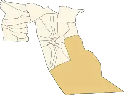 Location of Douar El Ma commune within El Oued Province | |
 Douar El Ma Location of Douar El Mar within Algeria | |
| Coordinates: 33°22′20″N 7°41′10″E | |
| Country | |
| Province | El Oued Province |
| District | Taleb Larbi District |
| Elevation | 52 m (171 ft) |
| Population (2008)[1] | |
| • Total | 5,543 |
| Time zone | UTC+1 (CET) |
Climate
Douar El Ma has a hot desert climate (Köppen climate classification BWh), with very hot summers and mild winters, and very little precipitation throughout the year.
| Climate data for Douar El Ma | |||||||||||||
|---|---|---|---|---|---|---|---|---|---|---|---|---|---|
| Month | Jan | Feb | Mar | Apr | May | Jun | Jul | Aug | Sep | Oct | Nov | Dec | Year |
| Average high °C (°F) | 16.8 (62.2) |
19.6 (67.3) |
23.3 (73.9) |
27.5 (81.5) |
32.6 (90.7) |
36.9 (98.4) |
40.6 (105.1) |
39.8 (103.6) |
35.2 (95.4) |
28.8 (83.8) |
22.0 (71.6) |
16.9 (62.4) |
28.3 (83.0) |
| Daily mean °C (°F) | 10.8 (51.4) |
13.2 (55.8) |
16.5 (61.7) |
20.4 (68.7) |
25.3 (77.5) |
29.8 (85.6) |
32.7 (90.9) |
32.4 (90.3) |
28.5 (83.3) |
22.4 (72.3) |
15.9 (60.6) |
11.2 (52.2) |
21.6 (70.9) |
| Average low °C (°F) | 4.8 (40.6) |
6.9 (44.4) |
9.8 (49.6) |
13.4 (56.1) |
18.1 (64.6) |
22.8 (73.0) |
24.9 (76.8) |
25.0 (77.0) |
21.9 (71.4) |
16.1 (61.0) |
9.9 (49.8) |
5.5 (41.9) |
14.9 (58.9) |
| Average precipitation mm (inches) | 8 (0.3) |
7 (0.3) |
11 (0.4) |
7 (0.3) |
5 (0.2) |
2 (0.1) |
0 (0) |
1 (0.0) |
5 (0.2) |
7 (0.3) |
11 (0.4) |
8 (0.3) |
72 (2.8) |
| Source: climate-data.org[3] | |||||||||||||
Education
1.0% of the population has a tertiary education (the lowest in the province), and another 5.3% has completed secondary education.[4] The overall literacy rate is 45.3%, and is 51.3% among males and 39.2% among females; all three rates are the lowest in the province.[5]
Localities
The commune of Douar El Ma is composed of four localities:[6]
- Douar El Ma
- Mih Naceur
- Bir Romane
- Bir Djedid
References
- "Population: El Oued Wilaya" (PDF) (in French). Office National des Statistiques Algérie. Archived from the original (PDF) on 13 May 2013. Retrieved 12 February 2013.
- "Algeria Communes". Statoids. Retrieved 9 March 2013.
- "Climate data for: Douar El Ma". climate-data.org. Retrieved 10 April 2013.
- "Structure relative de la population résidente des ménages ordinaires et collectifs âgée de 6 ans et plus selon le niveau d'instruction et la commune de résidence" (PDF) (in French). Office National des Statistiques Algérie. Archived from the original (PDF) on 13 May 2013. Retrieved 13 February 2013.
- "Taux d'analphabétisme et taux d'alphabétisation de la population âgée de 15 ans et plus, selon le sexe et la commune de résidence " (PDF) (in French). Office National des Statistiques Algérie. Archived from the original (PDF) on 13 May 2013. Retrieved 13 February 2013.
- "Décret n° 84-365, fixant la composition, la consistance et les limites territoriale des communes. Wilaya d'El Oued" (PDF) (in French). Journal officiel de la République Algérienne. 19 December 1984. p. 1564. Archived from the original (PDF) on 2 March 2013 or before. Retrieved 2 March 2013. Check date values in:
|archive-date=(help)
Places adjacent to Douar El Ma | ||||||||||
|---|---|---|---|---|---|---|---|---|---|---|
| ||||||||||
.svg.png.webp)