Duhonw
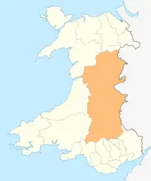
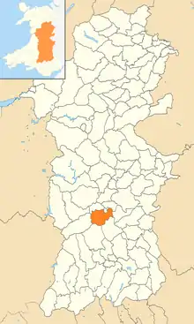
Duhonw is a rural community in Powys, Wales, to the south of Builth Wells (Welsh: Llanfair ym Muallt), in the historic county of Breconshire.[1] Covering an area of 4,376 hectares (16.90 sq mi) and including scattered farms and dwellings, it is bounded to its north by the Afon Irfon, to its south by Mynydd Epynt and Banc y Celyn (472m) and to its east the rivers Duhonw and Wye (Afon Gwy).[1][2] Llangammarch Wells' (Welsh: Llangamarch) is to its west.
Its population was 294, according to the 2011 census;[2] a 2% fall since the 300 people noted in 2001.[3]
The 2011 census showed 14.6% of the population could speak Welsh, a rise from 9.2% in 2001.[4]
Duhonw Community Council was created following a 1985 review by the Local Government Boundary Commission for Wales, amalgamating the four small communities of Llanddewi'r Cwm, Llangynog, Llanynis and Maesmynis.[1]
Duhonw is part of the Sennybridge Training Area,[5] and is listed as a Site of Special Scientific Interest.
See also
References
- "Final Proposals – Brecknockshire – Community - B03 04 07 Builth Wells Cilmery Duhonw" (PDF). Powys County Council. 3 April 2007. Archived from the original (PDF) on 7 October 2015. Retrieved 14 August 2015.
- "Area: Duhonw (Parish)". Office for National Statistics. 30 January 2013. Retrieved 14 August 2015.
- "Area: Duhonw (Parish)". Office for National Statistics. 18 November 2004. Retrieved 14 August 2015.
- "2011 Census results by Community". Welsh Language Commissioner. 2015. Retrieved 14 August 2015.
- "Blaen Duhonw deserted rural settlement, Llangammarch Wells". CBHC Coflein website. Royal Commission on the Ancient and Historical Monuments of Wales. 10 September 2008. Retrieved 14 August 2015.
See also
- List of Sites of Special Scientific Interest in Brecknock