Grade I listed buildings in Powys
In the United Kingdom, the term listed building refers to a building or other structure officially designated as being of special architectural, historical, or cultural significance; Grade I structures are those considered to be "buildings of exceptional interest".[1] Listing was begun by a provision in the Town and Country Planning Act 1947. Once listed, strict limitations are imposed on the modifications allowed to a building's structure or fittings. In Wales,[2] the authority for listing under the Planning (Listed Buildings and Conservation Areas) Act 1990[3] rests with Cadw.
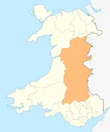
Powys shown within Wales
Buildings
| Name | Location | Date Listed | Grid Ref.[note 1] Geo-coordinates |
Function | Notes | Reference Number | Image |
|---|---|---|---|---|---|---|---|
| St Silin's Church | Llansilin | 4 January 1966 | SJ2096528185 52°50′43″N 3°10′30″W |
Church | At centre of village. Stone-walled churchyard with iron gates at west to High Street; prominent War Memorial of Celtic Cross form; sundial.[4][5] | 638 |  |
| Keep at Bronllys Castle | Bronllys | 28 September 1961 | SO1493834633 52°00′13″N 3°14′26″W |
Castle keep | Located strategically near the crossing of the Llynfi River, perched on a motte approximately 6m high[6][7] | 6616 | 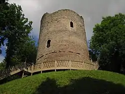 |
| St Ellyw's Church, Llanelieu | Talgarth | 28 September 1961 | SO1849234183 52°00′00″N 3°11′19″W |
Church | Located at the head of the Cwm Rhyd-Ellywe, within a raised oval walled churchyard.[8][9] | 6622 | 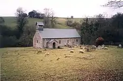 |
| Gatehouse to Great Porth-Amel | Talgarth | 28 September 1961 | SO1595235190 52°00′32″N 3°13′33″W |
gatehouse | Situated on the approach to Great Porth-amel farmhouse, by the side of the main road from Talgarth to Hay[10][11] | 6641 | 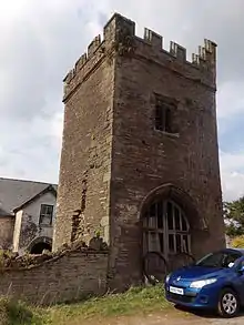 |
| Trefecca Fawr | Talgarth | 28 February 1952 | SO1427431691 51°58′37″N 3°14′58″W |
Country House | Situated S of Trefeca hamlet on a minor lane, about 100m from its junction with the B4560 Talgarth to Llangors road[12][13] | 6653 | 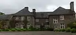 |
| Old Gwernyfed | Gwernyfed | 28 February 1952 | SO1824936558 52°01′17″N 3°11′34″W |
House | Located on NW side of road from Talgarth to Felindre, and set within its own grounds at the end of an axial driveway from the entrance gates on the road. The former farm buildings lie immediately to the NE of the drive.[14][15] | 6654 | 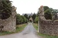 |
| Church of St Issui | Patrishow, The Vale of Grwyney | 19 July 1963 | SO2788822434 51°53′45″N 3°02′58″W |
Church | Isolated hillside church on W side of Afon Grwyne Fawr.[16][17] | 6687 | 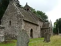 |
| Llangynidr Bridge (partly in Llanfihangel Cwmdu with Bwlch and Cathedine community) | Llangynidr | 4 January 1952 | SO1520920262 51°52′28″N 3°13′59″W |
Bridge | Impressively-sited spanning the River Usk on the B4560 in Lower Llangynidr.[18][19] | 6694 | 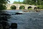 |
| Church of Saint David | Llanddew | 17 January 1963 | SO0548330743 51°58′02″N 3°22′38″W |
Church | In a prominent position in Llanddew, in the churchyard just W of the crossroads in the centre of the village.[20][21] | 6730 | 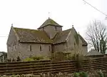 |
| Church of Saint Matthew | Llandefalle, Felin-fach | 17 January 1963 | SO1075535574 52°00′41″N 3°18′06″W |
Church | In the churchyard in the centre of Llandefalle some 900m W of the A470.[22][23] | 6731 | 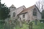 |
| Church of St Bilo | Llanfilo, Felin-fach | 17 January 1963 | SO1190033252 51°59′27″N 3°17′04″W |
Church | In the centre of the village of Llanfilo.[24][25] | 6742 | 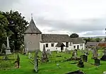 |
| Treberfydd (also known as Treberfedd) | Llangors | 17 January 1963 | SO1293425509 51°55′17″N 3°16′03″W |
House | On rising ground above the S shore of Lake Llangorse, overlooking the Lake and Mynydd Troed, standing in a large garden and parkland reached by front and rear drives.[26][27] | 6757 |  |
| Church of Saint Cynog | Defynnog, Maescar | 17 January 1963 | SN9253627929 51°56′22″N 3°33′53″W |
Church | Situated in large churchyard in the centre of Defynnog village.[28][29] | 6774 | 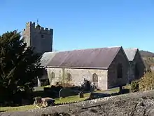 |
| Abercamlais including Dovecote Cottage | Trallong | 17 January 1963 | SN9649529014 51°57′00″N 3°30′27″W |
Country House | Situated down drive to N of A 40, some 4 km E of Sennybridge.[30][31] | 6785 | .jpg.webp) |
| Church of Saint David | Llywel | 17 January 1963 | SN8694230054 51°57′27″N 3°38′48″W |
Church | Situated some 1.2 km NW of Trecastle, on N side of A40, and E side of road to Tirabad.[32][33] | 6792 | .jpg.webp) |
| The Tower | Talybont-on-Usk | 25 September 1951 | SO1046324940 51°54′57″N 3°18′12″W |
Tower | At the S edge of Scethrog hamlet, bordering the River Usk, on a mound and surrounded by a vestigial moat within a stone walled garden. Reached off S side of A40.[34][35] | 6800 | |
| Penpont including attached conservatory and rear service ranges | Trallong | 25 September 1951 | SN9716028748 51°56′52″N 3°29′52″W |
House | Situated down drive N of A40, on S bank of the Usk.[36][37] | 6802 | |
| Newton House | Brecon | 25 September 1951 | SO0337828660 51°56′53″N 3°24′26″W |
House | Between the road and the River Usk; reached via drive to Golf Course.[38][39] | 6803 | |
| Usk Bridge | Brecon | 16 December 1976 | SO0429928591 51°56′51″N 3°23′38″W |
Spanning River Usk, and linking Bridge Street with Watergate.[40][41] | 6815 | .jpg.webp) | |
| Chapel and Remains of Nave of former Friary at Christ College | Brecon | 16 December 1976 | SO0428728441 51°56′46″N 3°23′38″W |
Chapel | Within grounds of Christ College, to N of main school building.[42][43] | 6826 | 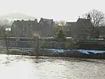 |
| Ely Tower of Brecon Castle | Brecon | 16 December 1976 | SO0424328793 51°56′58″N 3°23′41″W |
Tower | On motte to NE of Castle Hotel, within walled grounds of Bishop's Residence.[44][45] | 6849 | 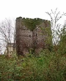 |
| Remains of the Great Hall of Brecon Castle | Brecon | 16 January 1952 | SO0430428724 51°56′56″N 3°23′38″W |
Great Hall | To E of Brecon Castle Hotel into which it has been partially incorporated.[46][47] | 6851 | 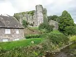 |
| Cathedral Church of St John the Baptist | Brecon | 16 January 1952 | SO0444329003 51°57′05″N 3°23′31″W |
Cathedral | In large precinct to north of historic centre of Brecon.[48] | 6998 | .jpg.webp) |
| The Canonry and Vestries, Cathedral of St John the Baptist | Brecon | 16 January 1952 | SO0441528967 51°57′04″N 3°23′32″W |
Canonry | Running S from the SW corner of the Cathedral.[49][50] | 7002 | 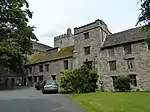 |
| Chapter House, Clergy House and Deanery | Brecon | 16 January 1952 | SO0445128937 51°57′03″N 3°23′30″W |
Chapter House | About 40m S of south transept of Cathedral.[51][52] | 7003 | .jpg.webp) |
| Porth-Mawr Gatehouse, Brecon Road | Crickhowell | 4 January 1952 | SO2171718544 51°51′36″N 3°08′17″W |
Gatehouse | Gatehouse adjoins side of Porth Mawr House, Brecon Road.[53][54] | 7158 | 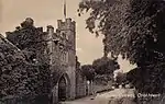 |
| Remains of Crickhowell Castle | Crickhowell | 19 July 1963 | SO2173618253 51°51′27″N 3°08′16″W |
Castle (ruined) | Situated to the SE of the High Street between Castle Road and Beaufort Street.[55][56] | 7192 | 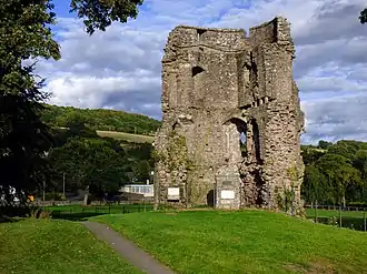 |
| Crickhowell Bridge | Crickhowell | 19 July 1963 | SO2147318169 51°51′24″N 3°08′30″W |
Bridge | Situated to SW of the town, spanning the River Usk.[57][58] | 7237 | 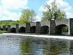 |
| Hay Castle | Hay-on-Wye | 24 October 1951 | SO2292542336 52°04′26″N 3°07′34″W |
Castle | Dominating the town with Back Fold, Castle Lane and Oxford Road bordering the castle grounds.[59][60] | 7405 | 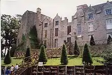 |
| Theatre at Craig-y-nos | Tawe Uchaf | 14 March 1985 | SN8401715427 51°49′31″N 3°41′04″W |
Theatre | The theatre is attached to the NW of the house with entrance from the corner of the front courtyard.[61][62] | 7492 | |
| Dolforwyn Castle | Llandyssil | 10 March 1953 | SO1519495030 52°32′47″N 3°15′07″W |
Castle | Located on a sharp promontory above the Severn Valley, in an excellent defensive position, with good views all round.[63][64] | 7550 | 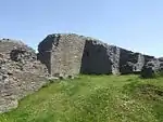 |
| Church of St Michael and All Angels | Kerry | 10 March 1953 | SO1471790101 52°30′08″N 3°15′28″W |
Church | Located within a circular churchyard on the N side of the Square, at the centre of Kerry village.[65][66] | 7558 | 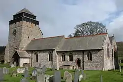 |
| Llandrinio Bridge (partly within the community area of Bausley with Criggion) | Llandrinio | 31 January 1953 | SJ2983616988 52°44′45″N 3°02′27″W |
Bridge | Carries the Llanfyllin to Shrewsbury Road over the River Severn.[67][68] | 7614 | 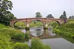 |
| Church of St Melangell | Llangynog | 31 January 1953 | SJ0242026550 52°49′39″N 3°26′59″W |
Church | In the upper part of Cwm Pennant, close to the confluence of Cwm Nant-ewyn. Preaching cross shaft in churchyard, reused as sundial pillar.[69][70] | 7634 | 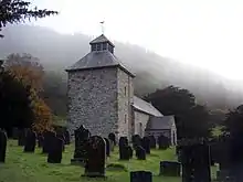 |
| Parish Church of St Tysilio and St Mary | Meifod | 31 January 1953 | SJ1553713185 52°42′35″N 3°15′06″W |
Church | Located near the centre of the extensive 3.6ha (9-acre) churchyard, within the village of Meifod.[71][72] | 7646 | 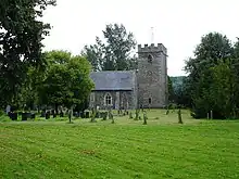 |
| Powis Castle | Welshpool | 25 April 1950 | SJ2158406451 52°39′00″N 3°09′38″W |
Castle | On a rock outcrop, in parkland to the S of the town.[73][74] | 7746 | 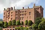 |
| Marquess Gate with steps leading to E entrance to Powis Castle, and flanking wall to N | Welshpool | 11 March 1981 | SJ2161706463 52°39′01″N 3°09′36″W |
Gateway | At the NE approach to the castle, facing Welshpool.[75][76] | 7747 | |
| Brick Wall to rear of Top Terrace at Powis Castle Gardens | Welshpool | 11 March 1981 | SJ2160006440 52°39′00″N 3°09′37″W |
Wall | The raised terrace lies immediately S of the flight of steps leading from the Marquess Gate to the E entrance to the castle.[77][78] | 7748 | .jpg.webp) |
| St Mary's Church | Welshpool | 11 March 1981 | SJ2255907662 52°39′40″N 3°08′47″W |
Church | Above the road in a steeply climbing churchyard.[79][80] | 7776 | .jpg.webp) |
| Church of St Aelhaiarn including outbuilding to W end of N aisle, and outbuilding on W side of porch | Guilsfield | 25 April 1950 | SJ2192511655 52°41′49″N 3°09′24″W |
Church | Situated in a large oval raised graveyard at the centre of the village[81][82] | 7866 | 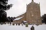 |
| Church of All Saints, Buttington | Trewern | 25 April 1950 | SJ2498908841 52°40′20″N 3°06′39″W |
Church | Situated at the junction of the main Shrewsbury to Welshpool road and the B4388, the Leighton Road, near the River Severn crossing.[83][84] | 7902 | 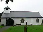 |
| Montgomery Castle | Montgomery | 19 July 1950 | SO2215296800 52°33′48″N 3°09′00″W |
Castle | Situated at the top of Castle Hill, reached by footpath from car park by Old Castle Farm.[85][86] | 7947 | 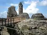 |
| Parish Church of Saint Nicholas | Montgomery | 19 July 1950 | SO2236296520 52°33′40″N 3°08′48″W |
Church | Situated in large churchyard bounded on S and E by Church Bank.[87][88] | 7950 | 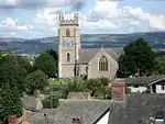 |
| Old Market Hall, Long Bridge Street | Llanidloes | 24 October 1950 | SN9541984523 52°26′55″N 3°32′25″W |
Market Hall | In the centre of town.[89][90] | 8317 | .jpg.webp) |
| Owain Glyndŵr's Parliament House | Machynlleth | 19 January 1952 | SH7481600841 52°35′27″N 3°50′58″W |
Parliament House | Midway along Heol Maengwyn, opposite the entrance to Plas Machynlleth[91][92] | 8429 | 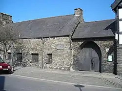 |
| Leighton Hall | Forden | 24 December 1982 | SJ2411104584 52°38′01″N 3°07′22″W |
Hall | Located approximately 1.4km S of Leighton church. The Hall is reached by private road on the E side of the B4388 Buttington to Forden road, and is set in landscaped gardens.[93][94] | 8663 | .jpg.webp) |
| Old Vicarage | Glasbury | 25 February 1952 | SO1772139031 52°02′37″N 3°12′04″W |
Located close to and on a bend of the River Wye, set apart from the village, at the far S end at the end of the road.[95][96] | 8734 | | |
| Maesyronnen Chapel | Glasbury | 18 September 1960 | SO1766641096 52°03′44″N 3°12′09″W |
Chapel | The chapel and adjoining cottage lie at the end of a lane off the road from the A.438 Hereford to Brecon Road to Ffynnon Gynnydd, near the top of a steep bank and overlooking the Cilcenni Dingle.[97][98] | 8756 | 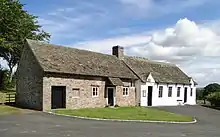 |
| Parish Church of St Mary | Gladestry | 21 September 1962 | SO2306255107 52°11′20″N 3°07′37″W |
Church | Situated in open churchyard above B4594, on NW side of village centre.[99][100] | 8774 | 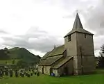 |
| Church of St David | Glascwm | 21 September 1962 | SO1559253151 52°10′13″N 3°14′08″W |
Church | In a round churchyard approximately 250m SW of the village centre and on the N side of the road through the village.[101][102] | 8780 | 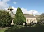 |
| Church of St Michael | Michaelchurch-on-Arrow, Gladestry | 21 September 1962 | SO2474250711 52°08′58″N 3°06′05″W |
Church | Situated in large churchyard uphill from road junction in middle of the village[103][104] | 8782 | |
| Bryndraenog | Beguildy | 24 October 1951 | SO2040978537 52°23′57″N 3°10′16″W |
House | Approximately 1.5km SE of Beguildy, reached by farm road on the W side of the B4355.[105][106] | 8792 | |
| Church of St Cewydd | Disserth and Trecoed | 31 May 1962 | SO0347358372 52°12′54″N 3°24′51″W |
Church | In a walled churchyard on the E bank of the River Ithon, and the S side of a minor road between Howey and Newbridge-on-Wye, approximately 1.7km WSW of Howey.[107][108] | 8806 | 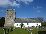 |
| St Andrew's Church | Presteigne | 28 November 1950 | SO3157864560 52°16′30″N 3°00′15″W |
Church | In a spacious churchyard close to the River Lugg with Broad Street low down east and Church Street to north-west.[109][110] | 8830 | 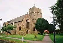 |
| Church of St Mary Magdalene | Bleddfa, Llangunllo | 24 October 1951 | SO2065468384 52°18′28″N 3°09′55″W |
Church | Central position in small hamlet of Bleddfa. Nearly circular churchyard set back from triangular green on north side of A488. Ancient site, traditionally founded by the Irish saint Brendan in C6.[111][112] | 9122 | 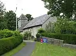 |
| Monaughty House | Llangunllo | 24 October 1951 | SO2381568580 52°18′36″N 3°07′08″W |
House | Situated to W of the junction of A488 and B4356.[113][114] | 9126 | 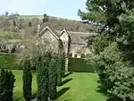 |
| Parish Church of St Stephen | Old Radnor | 15 February 1993 | SO2498859093 52°13′30″N 3°05′59″W |
Church | Elevated position on W flank of Old Radnor Hill in largely circular churchyard.[115][116] | 9131 | 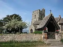 |
| Lake Vyrnwy Dam | Llanwddyn | 25 November 1993 | SJ0178019250 52°45′43″N 3°27′25″W |
Dam | In the Vyrnwy Valley, at the south-east end of this magnificent reservoir.[117][118] | 15621 | .jpg.webp) |
| Lake Vyrnwy Straining Tower and approach bridge | Llanwddyn | 25 November 1993 | SJ0120620149 52°46′12″N 3°27′57″W |
Water tower | On the north-east side of Lake Vrynwy visible from the dam; approached by a gated bridge from the lake-side road.[119][120] | 15622 | .jpg.webp) |
| Aviary Terrace in Powis Castle Gardens | Welshpool | 11 March 1981 | SJ2160806428 52°39′00″N 3°09′37″W |
Terrace | Forms the upper tier of the terraces immediately S of the castle[121][122] | 16775 | .jpg.webp) |
| Orangery Terrace in Gardens at Powis Castle | Welshpool | 11 March 1981 | SJ2161506421 52°38′59″N 3°09′36″W |
Terrace | Forms the middle tier of the terraces immediately S of the castle[123][124] | 16776 | .jpg.webp) |
| Apple Slope Terrace in Gardens at Powis Castle | Welshpool | 11 March 1981 | SJ2163306405 52°38′59″N 3°09′35″W |
Terrace | Forms the lowest tier of the terraces immediately S of the castle[125][126] | 16777 | |
| Outer Gateway at Powis Castle | Welshpool | 25 April 1950 | SJ2152706390 52°38′58″N 3°09′41″W |
Gateway | Forms the principle entrance to the castle, from the W. The retaining wall links the S pavilion with the main castle building.[127][128] | 16780 | |
| Retaining wall to courtyard at Powis Castle | Welshpool | 25 April 1950 | SJ2155706405 52°38′59″N 3°09′39″W |
Wall | Forms the principle entrance to the castle, from the W. The retaining wall links the S pavilion with the main castle building.[129][130] | 16781 | |
| Ballroom Range at Powis Castle | Welshpool | 25 April 1950 | SJ2153006420 52°38′59″N 3°09′41″W |
Forms the N boundary of the courtyard to the W of the main castle building.[131][132] | 16782 | | |
| Cottage attached to Maesyronnen United Reformed Chapel | Glasbury | 18 September 1960 | SO1765341098 52°03′44″N 3°12′09″W |
Cottage | The chapel and adjoining cottage lie at the end of a lane off the road from the A.438 Hereford to Brecon Road to Ffynnon Gynnydd, near the top of a steep bank and overlooking the Cilcenni Dingle.[133][134] | 17220 | |
| Leighton Hall Tower | Forden | 24 December 1982 | SJ2414704555 52°38′00″N 3°07′20″W |
Tower | Located approximately 1.4km S of Leighton church. The Tower is SE of Leighton Hall, reached by short private road E of B4388. A second (currently disused) service road leads to SW side of the Tower. The Tower has landscaped gardens to S and E.[135][136] | 19523 | .jpg.webp) |
| Ty Mawr | Castle Caereinion | 16 September 1998 | SJ1727004365 52°37′51″N 3°13′26″W |
Located on a platform site adjacent to the by-road leading SW off the B4345 to Berriew, S of Castle Caereinion.[137][138] | 20509 |  | |
| Tretower Court | Llanfihangel Cwmdu with Bwlch and Cathedine | 21 October 1998 | SO1858021187 51°53′00″N 3°11′04″W |
Country house | Approximately 150m S of the parish church on W side of a minor road between Tretower and A40[139][140] | 20656 | .jpg.webp) |
| Tretower Castle | Llanfihangel Cwmdu with Bwlch and Cathedine | 21 October 1998 | SO1845621260 51°53′02″N 3°11′10″W |
Castle | Prominently sited SW of church on S side of Ty Llys farm, W of Tretower Court. Farm buildings are contained within the bailey walls[141][142] | 20662 |  |
| Llangynidr Bridge | Llangynidr / Llanfihangel Cwmdu | 21 October 1998 | SO1521420306 51°52′30″N 3°13′59″W |
Bridge | Spanning the River Usk on the B4560.[143][144] | 20677 | |
| Crickhowell Bridge | Crickhowell / Llangattock | 21 October 1998 | SO2142518146 51°51′23″N 3°08′32″W |
Bridge | Located between Crickhowell and Llangattock communities 0.4km NE of the Church of St. Cattwg. The bridge crosses the River Usk, and extends southwards, with its southernmost arch spanning the Nant Onnau, before its confluence with the River Usk.[145][146] | 20716 | |
Notes
- Sometimes known as OSGB36, the grid reference is based on the British national grid reference system used by the Ordnance Survey.
References
- "Buildings & Conservation Areas". Cadw. Retrieved 18 June 2013.
- "Coflein". online database of RCAHMW. Royal Commission on the Ancient and Historical Monuments of Wales. Retrieved 28 November 2016.
- "Planning (Listed Buildings and Conservation Areas) Act 1990". The National Archives. Retrieved 18 June 2013.
- Cadw. "Church of St Silin (638)". National Historic Assets of Wales. Retrieved 8 April 2019.
- "Church of St Silin". British Listed Buildings. Retrieved 8 April 2019.
- Cadw. "Keep at Bronllys Castle (6616)". National Historic Assets of Wales. Retrieved 8 April 2019.
- "Keep at Bronllys Castle". British Listed Buildings. Retrieved 8 April 2019.
- Cadw. "Church of St Ellywe (6622)". National Historic Assets of Wales. Retrieved 8 April 2019.
- "Church of St Ellywe". British Listed Buildings. Retrieved 8 April 2019.
- Cadw. "Gatehouse to Great Porthamel (6641)". National Historic Assets of Wales. Retrieved 8 April 2019.
- "Gatehouse to Great Porthamel". British Listed Buildings. Retrieved 8 April 2019.
- Cadw. "Trefecca Fawr (6653)". National Historic Assets of Wales. Retrieved 8 April 2019.
- "Trefecca Fawr". British Listed Buildings. Retrieved 8 April 2019.
- Cadw. "Old Gwernyfed (6654)". National Historic Assets of Wales. Retrieved 8 April 2019.
- "Old Gwernyfed". British Listed Buildings. Retrieved 8 April 2019.
- Cadw. "Church of St Issui, Partrishow (6687)". National Historic Assets of Wales. Retrieved 8 April 2019.
- "Church of St Issui, Partrishow". British Listed Buildings. Retrieved 8 April 2019.
- Cadw. "Llangynidr Bridge (partly in Llanfihangel Cwmdu with Bwlch and Cathedine community) (6694)". National Historic Assets of Wales. Retrieved 8 April 2019.
- "Llangynidr Bridge (partly in Llanfihangel Cwmdu with Bwlch and Cathedine community)". British Listed Buildings. Retrieved 8 April 2019.
- Cadw. "Church of Saint David (6730)". National Historic Assets of Wales. Retrieved 8 April 2019.
- "Church of Saint David". British Listed Buildings. Retrieved 8 April 2019.
- Cadw. "Church of Saint Matthew (6731)". National Historic Assets of Wales. Retrieved 8 April 2019.
- "Church of Saint Matthew". British Listed Buildings. Retrieved 8 April 2019.
- Cadw. "Church of St Bilo (6742)". National Historic Assets of Wales. Retrieved 8 April 2019.
- "Church of St Bilo". British Listed Buildings. Retrieved 8 April 2019.
- Cadw. "Treberfydd (also known as Treberfedd) (6757)". National Historic Assets of Wales. Retrieved 8 April 2019.
- "Treberfydd (also known as Treberfedd)". British Listed Buildings. Retrieved 8 April 2019.
- Cadw. "Church of Saint Cynog (6774)". National Historic Assets of Wales. Retrieved 8 April 2019.
- "Church of Saint Cynog". British Listed Buildings. Retrieved 8 April 2019.
- Cadw. "Abercamlais including Dovecote Cottage (6785)". National Historic Assets of Wales. Retrieved 8 April 2019.
- "Abercamlais including Dovecote Cottage". British Listed Buildings. Retrieved 8 April 2019.
- Cadw. "Church of Saint David (6792)". National Historic Assets of Wales. Retrieved 8 April 2019.
- "Church of Saint David". British Listed Buildings. Retrieved 8 April 2019.
- Cadw. "The Tower (6800)". National Historic Assets of Wales. Retrieved 8 April 2019.
- "The Tower". British Listed Buildings. Retrieved 8 April 2019.
- Cadw. "Penpont including attached conservatory and rear service ranges (6802)". National Historic Assets of Wales. Retrieved 8 April 2019.
- "Penpont including attached conservatory and rear service ranges". British Listed Buildings. Retrieved 8 April 2019.
- Cadw. "Newton House (6803)". National Historic Assets of Wales. Retrieved 8 April 2019.
- "Newton House". British Listed Buildings. Retrieved 8 April 2019.
- Cadw. "Usk Bridge (6815)". National Historic Assets of Wales. Retrieved 8 April 2019.
- "Usk Bridge". British Listed Buildings. Retrieved 8 April 2019.
- Cadw. "Chapel and Remains of Nave of Former Friary at Christ College (6826)". National Historic Assets of Wales. Retrieved 8 April 2019.
- "Chapel and Remains of Nave of Former Friary at Christ College". British Listed Buildings. Retrieved 8 April 2019.
- Cadw. "Ely Tower of Brecon Castle (6849)". National Historic Assets of Wales. Retrieved 8 April 2019.
- "Ely Tower of Brecon Castle". British Listed Buildings. Retrieved 8 April 2019.
- Cadw. "Remains of the Great Hall of Brecon Castle (6851)". National Historic Assets of Wales. Retrieved 8 April 2019.
- "Remains of the Great Hall of Brecon Castle". British Listed Buildings. Retrieved 8 April 2019.
- Cadw. "Cathedral Church of St John the Evangelist (6998)". National Historic Assets of Wales. Retrieved 8 April 2019.
- Cadw. "The Deanery and Vestries, Cathedral of St John the Evangelist (7002)". National Historic Assets of Wales. Retrieved 8 April 2019.
- "The Deanery and Vestries, Cathedral of St John the Evangelist". British Listed Buildings. Retrieved 8 April 2019.
- Cadw. "Chapter House and Diocesan Centre (with Canonry Flat and Clergy House) (7003)". National Historic Assets of Wales. Retrieved 8 April 2019.
- "Chapter House and Diocesan Centre (with Canonry Flat and Clergy House)". British Listed Buildings. Retrieved 8 April 2019.
- Cadw. "Porth-Mawr Gatehouse (7158)". National Historic Assets of Wales. Retrieved 8 April 2019.
- "Porth-Mawr Gatehouse". British Listed Buildings. Retrieved 8 April 2019.
- Cadw. "Crickhowell Castle (remains of) (7192)". National Historic Assets of Wales. Retrieved 8 April 2019.
- "Crickhowell Castle (remains of)". British Listed Buildings. Retrieved 8 April 2019.
- Cadw. "Crickhowell Bridge (7237)". National Historic Assets of Wales. Retrieved 8 April 2019.
- "Crickhowell Bridge". British Listed Buildings. Retrieved 8 April 2019.
- Cadw. "Hay Castle (7405)". National Historic Assets of Wales. Retrieved 8 April 2019.
- "Hay Castle". British Listed Buildings. Retrieved 8 April 2019.
- Cadw. "Theatre at Craig-y-nos (7492)". National Historic Assets of Wales. Retrieved 8 April 2019.
- "Theatre at Craig-y-nos". British Listed Buildings. Retrieved 8 April 2019.
- Cadw. "Dolforwyn Castle (7550)". National Historic Assets of Wales. Retrieved 8 April 2019.
- "Dolforwyn Castle". British Listed Buildings. Retrieved 8 April 2019.
- Cadw. "Church of St Michael and All Angels (7558)". National Historic Assets of Wales. Retrieved 8 April 2019.
- "Church of St Michael and All Angels". British Listed Buildings. Retrieved 8 April 2019.
- Cadw. "Llandrinio Bridge (7614)". National Historic Assets of Wales. Retrieved 8 April 2019.
- "Llandrinio Bridge". British Listed Buildings. Retrieved 8 April 2019.
- Cadw. "Church of St Melangell (7634)". National Historic Assets of Wales. Retrieved 8 April 2019.
- "Church of St Melangell". British Listed Buildings. Retrieved 8 April 2019.
- Cadw. "Parish Church of St Tysilio and St Mary (7646)". National Historic Assets of Wales. Retrieved 8 April 2019.
- "Parish Church of St Tysilio and St Mary". British Listed Buildings. Retrieved 8 April 2019.
- Cadw. "Powis Castle (7746)". National Historic Assets of Wales. Retrieved 8 April 2019.
- "Powis Castle". British Listed Buildings. Retrieved 8 April 2019.
- Cadw. "Marquess Gate with steps leading to E entrance to Powis Castle, and flanking wall to N (7747)". National Historic Assets of Wales. Retrieved 8 April 2019.
- "Marquess Gate with steps leading to E entrance to Powis Castle, and flanking wall to N". British Listed Buildings. Retrieved 8 April 2019.
- Cadw. "Brick Wall to rear of Top Terrace at Powis Castle Gardens (7748)". National Historic Assets of Wales. Retrieved 8 April 2019.
- "Brick Wall to rear of Top Terrace at Powis Castle Gardens". British Listed Buildings. Retrieved 8 April 2019.
- Cadw. "Church of Saint Mary (7776)". National Historic Assets of Wales. Retrieved 8 April 2019.
- "Church of Saint Mary". British Listed Buildings. Retrieved 8 April 2019.
- Cadw. "Church of St Aelhaiarn including Outbuilding to W end of N Aisle and outbuilding on W side of Porch (7866)". National Historic Assets of Wales. Retrieved 8 April 2019.
- "Church of St Aelhaiarn including Outbuilding to W end of N Aisle and outbuilding on W side of Porch". British Listed Buildings. Retrieved 8 April 2019.
- Cadw. "Church of All Saints (7902)". National Historic Assets of Wales. Retrieved 8 April 2019.
- "Church of All Saints". British Listed Buildings. Retrieved 8 April 2019.
- Cadw. "Montgomery Castle (7947)". National Historic Assets of Wales. Retrieved 8 April 2019.
- "Montgomery Castle". British Listed Buildings. Retrieved 8 April 2019.
- Cadw. "Parish Church of Saint Nicholas (7950)". National Historic Assets of Wales. Retrieved 8 April 2019.
- "Parish Church of Saint Nicholas". British Listed Buildings. Retrieved 8 April 2019.
- Cadw. "Old Market Hall (8317)". National Historic Assets of Wales. Retrieved 8 April 2019.
- "Old Market Hall". British Listed Buildings. Retrieved 8 April 2019.
- Cadw. "Owain Glyndwr's Parliament House (8429)". National Historic Assets of Wales. Retrieved 8 April 2019.
- "Owain Glyndwr's Parliament House". British Listed Buildings. Retrieved 8 April 2019.
- Cadw. "Leighton Hall (8663)". National Historic Assets of Wales. Retrieved 8 April 2019.
- "Leighton Hall". British Listed Buildings. Retrieved 8 April 2019.
- Cadw. "Old Vicarage (8734)". National Historic Assets of Wales. Retrieved 8 April 2019.
- "Old Vicarage". British Listed Buildings. Retrieved 8 April 2019.
- Cadw. "Maesyronnen United Reformed Chapel (8756)". National Historic Assets of Wales. Retrieved 8 April 2019.
- "Maesyronnen United Reformed Chapel". British Listed Buildings. Retrieved 8 April 2019.
- Cadw. "Parish Church of St Mary (8774)". National Historic Assets of Wales. Retrieved 8 April 2019.
- "Parish Church of St Mary". British Listed Buildings. Retrieved 8 April 2019.
- Cadw. "Church of St David (8780)". National Historic Assets of Wales. Retrieved 8 April 2019.
- "Church of St David". British Listed Buildings. Retrieved 8 April 2019.
- Cadw. "Church of St Michael (8782)". National Historic Assets of Wales. Retrieved 8 April 2019.
- "Church of St Michael". British Listed Buildings. Retrieved 8 April 2019.
- Cadw. "Bryndraenog (8792)". National Historic Assets of Wales. Retrieved 8 April 2019.
- "Bryndraenog". British Listed Buildings. Retrieved 8 April 2019.
- Cadw. "Church of St Cewydd (8806)". National Historic Assets of Wales. Retrieved 8 April 2019.
- "Church of St Cewydd". British Listed Buildings. Retrieved 8 April 2019.
- Cadw. "St Andrew's Church (8830)". National Historic Assets of Wales. Retrieved 8 April 2019.
- "St Andrew's Church". British Listed Buildings. Retrieved 8 April 2019.
- Cadw. "Church of St. Mary Magdalene (9122)". National Historic Assets of Wales. Retrieved 8 April 2019.
- "Church of St. Mary Magdalene". British Listed Buildings. Retrieved 8 April 2019.
- Cadw. "Monaughty House (9126)". National Historic Assets of Wales. Retrieved 8 April 2019.
- "Monaughty House". British Listed Buildings. Retrieved 8 April 2019.
- Cadw. "Parish Church of St Stephen (9131)". National Historic Assets of Wales. Retrieved 8 April 2019.
- "Parish Church of St Stephen". British Listed Buildings. Retrieved 8 April 2019.
- Cadw. "Lake Vyrnwy Dam (15621)". National Historic Assets of Wales. Retrieved 8 April 2019.
- "Lake Vyrnwy Dam". British Listed Buildings. Retrieved 8 April 2019.
- Cadw. "Lake Vyrnwy Straining Tower and approach bridge (15622)". National Historic Assets of Wales. Retrieved 8 April 2019.
- "Lake Vyrnwy Straining Tower and approach bridge". British Listed Buildings. Retrieved 8 April 2019.
- Cadw. "Aviary Terrace in Powis Castle Gardens (16775)". National Historic Assets of Wales. Retrieved 8 April 2019.
- "Aviary Terrace in Powis Castle Gardens". British Listed Buildings. Retrieved 8 April 2019.
- Cadw. "Orangery Terrace in Gardens at Powis Castle (16776)". National Historic Assets of Wales. Retrieved 8 April 2019.
- "Orangery Terrace in Gardens at Powis Castle". British Listed Buildings. Retrieved 8 April 2019.
- Cadw. "Apple Slope Terrace in Gardens at Powis Castle (16777)". National Historic Assets of Wales. Retrieved 8 April 2019.
- "Apple Slope Terrace in Gardens at Powis Castle". British Listed Buildings. Retrieved 8 April 2019.
- Cadw. "Outer Gateway at Powis Castle (16780)". National Historic Assets of Wales. Retrieved 8 April 2019.
- "Outer Gateway at Powis Castle". British Listed Buildings. Retrieved 8 April 2019.
- Cadw. "Retaining wall to courtyard at Powis Castle (16781)". National Historic Assets of Wales. Retrieved 8 April 2019.
- "Retaining wall to courtyard at Powis Castle". British Listed Buildings. Retrieved 8 April 2019.
- Cadw. "Ballroom Range at Powis Castle (16782)". National Historic Assets of Wales. Retrieved 8 April 2019.
- "Ballroom Range at Powis Castle". British Listed Buildings. Retrieved 8 April 2019.
- Cadw. "Cottage attached to Maesyronnen United Reformed Chapel (17220)". National Historic Assets of Wales. Retrieved 8 April 2019.
- "Cottage attached to Maesyronnen United Reformed Chapel". British Listed Buildings. Retrieved 8 April 2019.
- Cadw. "Leighton Hall Tower (19523)". National Historic Assets of Wales. Retrieved 8 April 2019.
- "Leighton Hall Tower". British Listed Buildings. Retrieved 8 April 2019.
- Cadw. "Ty Mawr (20509)". National Historic Assets of Wales. Retrieved 8 April 2019.
- "Ty Mawr". British Listed Buildings. Retrieved 8 April 2019.
- Cadw. "Tretower Court (20656)". National Historic Assets of Wales. Retrieved 8 April 2019.
- "Tretower Court". British Listed Buildings. Retrieved 8 April 2019.
- Cadw. "Tretower Castle (20662)". National Historic Assets of Wales. Retrieved 8 April 2019.
- "Tretower Castle". British Listed Buildings. Retrieved 8 April 2019.
- Cadw. "Llangynidr Bridge (partly in Llangynidr community) (20677)". National Historic Assets of Wales. Retrieved 8 April 2019.
- "Llangynidr Bridge (partly in Llangynidr community)". British Listed Buildings. Retrieved 8 April 2019.
- Cadw. "Crickhowell Bridge (partly in Crickhowell community) (20716)". National Historic Assets of Wales. Retrieved 8 April 2019.
- "Crickhowell Bridge (partly in Crickhowell community)". British Listed Buildings. Retrieved 8 April 2019.
External links
![]() Media related to Grade I listed buildings in Powys at Wikimedia Commons
Media related to Grade I listed buildings in Powys at Wikimedia Commons
This article is issued from Wikipedia. The text is licensed under Creative Commons - Attribution - Sharealike. Additional terms may apply for the media files.