Banwy
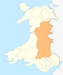
Banwy is a community in northwest Montgomeryshire, Powys, Wales,[1] named after the River Banwy and also called Banw in Welsh.
| Banwy | |
|---|---|
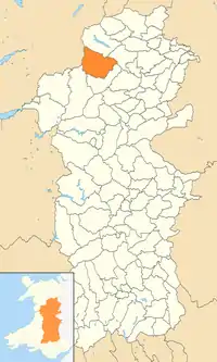 Location of Banwy community within Powys | |
| Principal area | |
| Ceremonial county | |
| Country | Wales |
| Sovereign state | United Kingdom |
| Post town | WELSHPOOL |
| Postcode district | SY21 |
| Dialling code | 01938 |
| Police | Dyfed-Powys |
| Fire | Mid and West Wales |
| Ambulance | Welsh |
| UK Parliament | |
The community with the villages of Llangadfan and Foel,[1] also called Garthbeibio. It is a sparsely populated area centred on the village of Llangadfan and extending west for some 10 km to the boundary with Gwynedd. It is located along the upper River Banwy valley, on either side of the A458 road between Llanfair Caereinion and Mallwyd.[2]
The population according to the 2011 UK census was 605.[3] In 2005, the population was 534.[1]
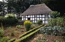
Abernodwydd Farmhouse, a wooden-framed farmhouse built in 1678 from the Llangadfan was reassembled at the St Fagans National Museum of History.[4] Banwy was the site of Ffridd y Castell, or Ffriddycastell. The site is located 6 miles (9.7 km) southwest of Llangadfan.[5]
References
- "Communities of Banwy and Llanerfyl" (PDF). Government of Powys. Retrieved 21 May 2017.
- "Banwy". Google maps. Retrieved 21 May 2017.
- "2011 Census Key Statistics, Banwy Community Council" (PDF). Government of Powys. Retrieved 21 May 2017.
- "Abernodwydd farmhouse". National Museums Wales. Retrieved 21 May 2017.
- "Ffridd y Castell (52.66864°, -3.52491) to Llangadfan". Google maps. Retrieved 21 May 2017.
External links
![]() Media related to Banwy at Wikimedia Commons
Media related to Banwy at Wikimedia Commons