Castle Caereinion
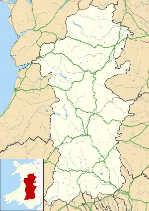
Castle Caereinion (Welsh: Castell Caereinion) is a small village and community in Montgomeryshire, Powys, Wales upon the River Banwy (also known as the River Einion), around 8 miles west of Welshpool, and 4 miles east of Llanfair Caereinion.
| Castle Caereinion | |
|---|---|
 Castle Caereinion Location within Powys | |
| Population | 592 (2011) |
| OS grid reference | SJ163055 |
| Principal area | |
| Ceremonial county | |
| Country | Wales |
| Sovereign state | United Kingdom |
| Post town | WELSHPOOL |
| Postcode district | SY21 |
| Dialling code | 01938 |
| Police | Dyfed-Powys |
| Fire | Mid and West Wales |
| Ambulance | Welsh |
| UK Parliament | |
| Senedd Cymru – Welsh Parliament | |
In 2011 the ward had a population of 1810.[1] The community had a population of 592. [2] Castle Caereinion railway station is on the Welshpool and Llanfair Light Railway.[3]
The village is named after an ancient castle. The castle was built in 1156 by Madog ap Maredudd. Madog's nephew Owain Cyfeiliog swore allegiance to the English, Owain Gwynedd took the castle from him and destroyed it in about 1167. It has been suggested that a mound in the churchyard of St Garmon's is the remains of the earthwork castle. This mound is known as Twmpath Garmon, so it could be a preaching mound (as in Llanfechain). The most recent view is that the mound does not appear motte-like and a survey in 2002 failed to find a surrounding ditch.[4]
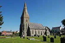
The church of St Garmon was completely rebuilt in 1866 with additions in 1874. Its predecessor was 15th century. Some of the fittings from the earlier church survive, mostly from the 18th century. St Garmon's was not an important ecclesiastical centre, being classed as a chapel in 1254.[4]
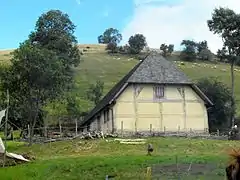
Tŷ Mawr, a Grade I timber framed house, is in Trefnant within the parish of Castle Caereinion, this house represents an important surviving medieval hall house built for gentry of high which, denrochronological evidence suggests was built around 1490, The house was restored in 1997–1998 and is again being used as a home.[5]
References
- 2011 Census Key Statistics Llanfair Caereinion 2011 Census Ward. Powys County Council. February 2012.
- https://www.nomisweb.co.uk/reports/localarea?compare=W04000262
- Rushton, Gordon (2015). The Welshpool & Llanfair Railway Travellers's Guide Llanfair Caereinion. Welshpool & Llanfair Railway.
- "Castle Caereinion - Historic settlement survey" (PDF). CPAT.
- "TY-MAWR HALL HOUSE, CASTLE CAEREINION". Royal Commission on the Ancient and Historical Monuments of Wales. Retrieved 24 March 2020.
External links
| Authority control |
|
|---|