Earth's circumference
Earth's circumference is the distance around Earth. Measured around the poles, the circumference is 40,007.863 km (24,859.734 mi). Measured around the Equator, it is 40,075.017 km (24,901.461 mi).[1]
Measurement of Earth's circumference has been important to navigation since ancient times. The first known scientific measurement and calculation was done by Eratosthenes, who achieved a great degree of precision in his computation.[2] Treated as a sphere, determining Earth's circumference would be its single most important measurement.[3] Earth deviates from spherical by about 0.3%, as characterized by flattening.
In modern times, Earth's circumference has been used to define fundamental units of measurement of length: the nautical mile in the seventeenth century and the metre in the eighteenth. Earth's polar circumference is very near to 21,600 nautical miles because the nautical mile was intended to express one minute of latitude, which is 21,600 partitions of the polar circumference (i.e. 60 × 360). The polar circumference is also close to 40,000 kilometres because the metre was originally defined to be one 10-millionth of the circumferential distance from pole to equator. The physical length of each unit of measure has remained close to what it was determined to be at the time, but the precision of measuring the circumference has improved since then.
History of calculation
| Geodesy |
|---|
 |
Eratosthenes
The measure of Earth's circumference is the most famous among the results obtained by Eratosthenes,[4] who estimated that the meridian has a length of 252,000 stadia, with an error on the real value between -2.4% and +0.8% (assuming a value for the stadion between 155 and 160 metres).[2] Eratosthenes described his technique in a book entitled On the measure of the Earth, which has not been preserved.
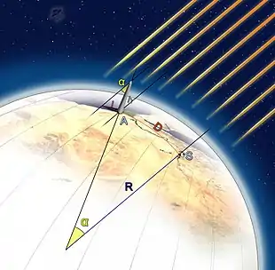
Eratosthenes' method to calculate Earth's circumference has been lost; what has been preserved is the simplified version described by Cleomedes to popularise the discovery.[5] Cleomedes invites his reader to consider two Egyptian cities, Alexandria and Syene, modern Assuan:
- Cleomedes assumes that the distance between Syene and Alexandria was 5,000 stadia (a figure that was checked yearly by professional bematists, mensores regii);[6]
- he assumes the simplified (but false) hypothesis that Syene was precisely on the Tropic of Cancer, saying that at local noon on the summer solstice the Sun was directly overhead;
- he assumes the simplified (but false) hypothesis that Syene and Alexandria are on the same meridian.
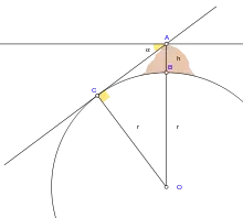
Under the previous assumptions, writes Cleomedes, you can measure the Sun's angle of elevation at noon of the summer solstice in Alexandria, by using a vertical rod (a gnomon) of known length and measuring the length of its shadow on the ground; it is then possible to calculate the angle of the Sun's rays, which he claims to be about 7°, or 1/50th the circumference of a circle. Taking the Earth as spherical, the Earth's circumference would be fifty times the distance between Alexandria and Syene, that is 250,000 stadia. Since 1 Egyptian stadium is equal to 157.5 metres, the result is 39,375 km, which is 1.6% less than the real number, 40,008 km.
Eratosthenes' method was actually more complicated, as stated by the same Cleomedes, whose purpose was to present a simplified version of the one described in Eratosthenes' book. The method was based on several surveying trips conducted by professional bematists, whose job was to precisely measure the extent of the territory of Egypt for agricultural and taxation-related purposes.[2] Furthermore, the fact that Eratosthenes' measure corresponds precisely to 252,000 stadia might be intentional, since it is a number that can be divided by all natural numbers from 1 to 10: some historians believe that Eratosthenes changed from the 250,000 value written by Cleomedes to this new value to simplify calculations;[7] other historians of science, on the other side, believe that Eratosthenes introduced a new length unit based on the length of the meridian, as stated by Pliny, who writes about the stadion “according to Eratosthenes' ratio”.[2][8]
Posidonius
Posidonius calculated the Earth's circumference by reference to the position of the star Canopus. As explained by Cleomedes, Posidonius observed Canopus on but never above the horizon at Rhodes, while at Alexandria he saw it ascend as far as 7 1⁄2 degrees above the horizon (the meridian arc between the latitude of the two locales is actually 5 degrees 14 minutes). Since he thought Rhodes was 5,000 stadia due north of Alexandria, and the difference in the star's elevation indicated the distance between the two locales was 1/48 of the circle, he multiplied 5,000 by 48 to arrive at a figure of 240,000 stadia for the circumference of the earth.[9] It is generally thought that the stadion used by Posidonius was almost exactly 1/10 of a modern statute mile. Thus Posidonius's measure of 240,000 stadia translates to 24,000 mi (39,000 km), not much short of the actual circumference of 24,901 mi (40,074 km).[9] Strabo noted that the distance between Rhodes and Alexandria is 3,750 stadia, and reported Posidonius's estimate of the Earth's circumference to be 180,000 stadia or 18,000 mi (29,000 km).[10] Pliny the Elder mentions Posidonius among his sources and without naming him reported his method for estimating the Earth's circumference. He noted, however, that Hipparchus had added some 26,000 stadia to Eratosthenes's estimate. The smaller value offered by Strabo and the different lengths of Greek and Roman stadia have created a persistent confusion around Posidonius's result. Ptolemy used Posidonius's lower value of 180,000 stades (about 33% too low) for the earth's circumference in his Geography. This was the number used by Christopher Columbus in order to underestimate the distance to India as 70,000 stades.[11]
Aryabhata
Around AD 525, the Indian mathematician and astronomer, Aryabhata wrote Aryabhatiya, in which he calculated the diameter of earth to be of 1,050 yojanas, which is roughly 12,500 kilometers.
Islamic Golden Age
Around AD 830, Caliph Al-Ma'mun commissioned a group of Muslim astronomers led by Al-Khwarizmi to measure the distance from Tadmur (Palmyra) to Raqqa, in modern Syria. They calculated the Earth's circumference to be within 15% of the modern value, and possibly much closer. How accurate it actually was is not known because of uncertainty in the conversion between the medieval Arabic units and modern units, but in any case, technical limitations of the methods and tools would not permit an accuracy better than about 5%.[12]
A more convenient way to estimate was provided in Al-Biruni's Codex Masudicus (1037). In contrast to his predecessors, who measured the Earth's circumference by sighting the Sun simultaneously from two different locations, al-Biruni developed a new method of using trigonometric calculations, based on the angle between a plain and mountain top, which made it possible for it to be measured by a single person from a single location.[12] From the top of the mountain, he sighted the dip angle which, along with the mountain's height (which he calculated beforehand), he applied to the law of sines formula. This was the earliest known use of dip angle and the earliest practical use of the law of sines.[13] However, the method could not provide more accurate results than previous methods, due to technical limitations, and so al-Biruni accepted the value calculated the previous century by the al-Ma'mun expedition.[12]
Columbus's error
1,700 years after Eratosthenes's death, Christopher Columbus studied what Eratosthenes had written about the size of the Earth. Nevertheless, based on a map by Toscanelli, he chose to believe that the Earth's circumference was 25% smaller. If, instead, Columbus had accepted Eratosthenes's larger value, he would have known that the place where he made landfall was not Asia, but rather a New World.[14]
Historical use in the definition of units of measurement
Both the metre and the nautical mile were originally defined as a subdivision of the Earth's circumference; today the circumference around the poles is very nearly 40,000 km and 360 × 60 nautical miles long.[15]
In 1617 the Dutch scientist Willebrord Snellius assessed the circumference of the Earth at 24,630 Roman miles (24,024 statute miles). Around that time British mathematician Edmund Gunter improved navigational tools including a new quadrant to determine latitude at sea. He reasoned that the lines of latitude could be used as the basis for a unit of measurement for distance and proposed the nautical mile as one minute or one-sixtieth (1/60) of one degree of latitude. As one degree is 1/360 of a circle, one minute of arc is 1/21600 of a circle – such that the polar circumference of the Earth would be exactly 21,600 miles. Gunter used Snell's circumference to define a nautical mile as 6,080 feet, the length of one minute of arc at 48 degrees latitude.[16]
In 1791, the French Academy of Sciences selected the circumference definition over the alternative pendular definition because the force of gravity varies slightly over the surface of the Earth, which affects the period of a pendulum.[17] To establish a universally accepted foundation for the definition of the metre, more accurate measurements of this meridian were needed. The French Academy of Sciences commissioned an expedition led by Jean Baptiste Joseph Delambre and Pierre Méchain, lasting from 1792 to 1799, which attempted to accurately measure the distance between a belfry in Dunkerque and Montjuïc castle in Barcelona to estimate the length of the meridian arc through Dunkerque. This portion of the meridian, assumed to be the same length as the Paris meridian, was to serve as the basis for the length of the half meridian connecting the North Pole with the Equator. The problem with this approach is that the exact shape of the Earth is not a simple mathematical shape, such as a sphere or oblate spheroid, at the level of precision required for defining a standard of length. The irregular and particular shape of the Earth smoothed to sea level is represented by a mathematical model called a geoid, which literally means "Earth-shaped". Despite these issues, in 1793 France adopted this definition of the metre as its official unit of length based on provisional results from this expedition. However, it was later determined that the first prototype metre bar was short by about 200 micrometres because of miscalculation of the flattening of the Earth, making the prototype about 0.02% shorter than the original proposed definition of the metre. Regardless, this length became the French standard and was progressively adopted by other countries in Europe.[17]
See also
References
- Humerfelt, Sigurd (26 October 2010). "How WGS 84 defines Earth". Archived from the original on 24 April 2011. Retrieved 29 April 2011.
- Russo, Lucio (2004). The Forgotten Revolution. Berlin: Springer. p. 273–277.
- Shashi Shekhar; Hui Xiong (12 December 2007). Encyclopedia of GIS. Springer Science & Business Media. pp. 638–640. ISBN 978-0-387-30858-6.
- Russo, Lucio. The Forgotten Revolution. p. 68..
- Cleomedes, Caelestia, i.7.49-52.
- Martianus Capella, De nuptiis Philologiae et Mercurii, VI.598.
- Rawlins, Dennis (1983). "The Erathostenes-Strabo Nile Map. Is It the Earliest Surviving Instance of Spherical Cartography? Did It Supply the 5000 Stades Arc for Erathostenes' Experiment?". Archive for History of Exact Sciences. 26 (26): 211–219. doi:10.1007/BF00348500 (inactive 8 January 2021).CS1 maint: DOI inactive as of January 2021 (link)
- Pliny, Naturalis Historia, XII $53.
- Posidonius, fragment 202
- Cleomedes (in Fragment 202) stated that if the distance is measured by some other number the result will be different, and using 3,750 instead of 5,000 produces this estimation: 3,750 x 48 = 180,000; see Fischer I., (1975), Another Look at Eratosthenes' and Posidonius' Determinations of the Earth's Circumference, Ql. J. of the Royal Astron. Soc., Vol. 16, p.152.
- John Freely, Before Galileo: The Birth of Modern Science in Medieval Europe (2012)
- Mercier, Raymond (1992). "Geodesy". In Harley, J.B.; Woodward, David (eds.). The History of Cartography, Volume 2, Book 1. The University of Chicago Press. pp. 175–188. ISBN 9780226316352.
- Behnaz Savizi (2007), "Applicable Problems in History of Mathematics: Practical Examples for the Classroom", Teaching Mathematics and Its Applications, Oxford University Press, 26 (1): 45–50, doi:10.1093/teamat/hrl009
- Gow, Mary. "Measuring the Earth: Eratosthenes and His Celestial Geometry, p. 6 (Berkeley Heights, NJ: Enslow, 2010).
- Garrison, Peter (April 2008). "Old Wings". Flying Magazine: 90. ISSN 0015-4806.: "The kilometer, which is the foundation of the entire SI or "metric" system, was originally intended to be 1/10,000th of a quadrant of a meridian – that is, 1/40,000th of the earth's polar circumference – and was established as such in 1793... The nautical mile, like the kilometer, is a unit based on the dimensions of the earth. It is the length of one minute of arc along a meridian. (The meridians are the lines that run from pole to pole on the globe; the other ones are called parallels, and minutes of arc on them shrink toward the poles.) One minute of arc is 1/21,600th of a full circumference, and so the polar circumference of the earth... is 21,600 nautical miles."
- Marine Insight, Why Nautical Mile and Knot Are The Units Used at Sea?
- Alder, Ken (October 2003). The Measure of All Things: The Seven-Year Odyssey and Hidden Error That Transformed the World. Simon and Schuster. ISBN 978-0-7432-1676-0.
Bibliography
| Wikimedia Commons has media related to Earth's circumference. |
- Krebs, Robert E.; Krebs, Carolyn A. (2003). "Calculating the Earth's Circumference". Groundbreaking Scientific Experiments, Inventions, and Discoveries of the Ancient World. Greenwood Publishing Group. p. 52. ISBN 978-0-313-31342-4.
- Nicastro, Nicholas (25 November 2008). Circumference: Eratosthenes and the Ancient Quest to Measure the Globe. St. Martin's Press. ISBN 978-1-4299-5819-6.
- Gow, Mary (1 July 2009). Measuring the Earth: Eratosthenes and His Celestial Geometry. Enslow Publishing, LLC. ISBN 978-0-7660-3120-3.
- Lowrie, William (20 September 2007). Fundamentals of Geophysics. Cambridge University Press. ISBN 978-1-139-46595-3.