Longitude
Longitude (/ˈlɒndʒɪtjuːd/, AU and UK also /ˈlɒŋɡɪ-/),[1][2] is a geographic coordinate that specifies the east–west position of a point on the Earth's surface, or the surface of a celestial body. It is an angular measurement, usually expressed in degrees and denoted by the Greek letter lambda (λ). Meridians (lines running from pole to pole) connect points with the same longitude. The prime meridian, which passes near the Royal Observatory, Greenwich, England, is defined as 0° longitude by convention. Positive longitudes are east of the prime meridian, and negative ones are west.

 |
| Longitude (λ) |
|---|
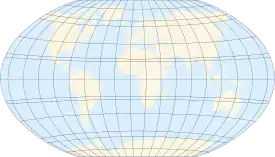
| Lines of longitude appear vertical with varying curvature in this projection, but are actually halves of great ellipses, with identical radii at a given latitude. |
| Latitude (φ) |
| Lines of latitude appear horizontal with varying curvature in this projection; but are actually circular with different radii. All locations with a given latitude are collectively referred to as a circle of latitude. |
|
|
| Geodesy |
|---|
 |
Because of the earth's rotation, there is a close connection between longitude and time. Local time (for example from the position of the sun) varies with longitude, a difference of 15° longitude corresponding to a one-hour difference in local time. Comparing local time to an absolute measure of time allows longitude to be determined. Depending on the era, the absolute time might be obtained from a celestial event visible from both locations, such as a lunar eclipse, or from a time signal transmitted by telegraph or wireless. The principle is straightforward, but in practice finding a reliable method of determining longitude took centuries and required the effort of some of the greatest scientific minds.
A location's north–south position along a meridian is given by its latitude, which is approximately the angle between the local vertical and the equatorial plane.
Longitude is generally given using the geometrical or astronomical vertical. This can differ slightly from the gravitational vertical because of small variations in Earth's gravitational field.
History
The concept of longitude was first developed by ancient Greek astronomers. Hipparchus (2nd century BCE) used a coordinate system that assumed a spherical earth, and divided it into 360° as we still do today. His prime meridian passed through Alexandria.[3]:31 He also proposed a method of determining longitude by comparing the local time of a lunar eclipse at two different places, thus demonstrating an understanding of the relationship between longitude and time.[3]:11.[4] Claudius Ptolemy (2nd century CE) developed a mapping system using curved parallels that reduced distortion. He also collected data for many locations, from Britain to the Middle East. He used a prime meridian through the Canary Islands, so that all longitude values would be positive. While Ptolemy's system was sound, the data he used were often poor, leading to a gross over-estimate (by about 70%) of the length of the Mediterranean.[5][6]:551–553[7]
After the fall of the Roman Empire, interest in geography greatly declined in Europe.[8]:65 Hindu and Muslim astronomers continued to develop these ideas, adding many new locations and often improving on Ptolemy's data.[9][10] For example al-Battānī used simultaneous observations of two lunar eclipses to determine the difference in longitude between Antakya and Raqqa with an error of less than 1°. This is considered to be the best that can be achieved with the methods then available - observation of the eclipse with the naked eye, and determination of local time using an astrolabe to measure the altitude of a suitable "clock star".[11][12]
In the later Middle Ages, interest in geography revived in the west, as travel increased, and Arab scholarship began to be known through contact with Spain and North Africa. In the 12th Century, astronomical tables were prepared for a number of European cities, based on the work of al-Zarqālī in Toledo. The lunar eclipse of September 12, 1178 was used to establish the longitude differences between Toledo, Marseilles, and Hereford.[13]:85
Christopher Columbus made two attempts to use lunar eclipses to discover his longitude, the first in Saona Island, on 14 September 1494 (second voyage), and the second in Jamaica on 29 February 1504 (fourth voyage). It is assumed that he used astronomical tables for reference. His determinations of longitude showed large errors of 13 and 38° W respectively.[14] Randles (1985) documents longitude measurement by the Portuguese and Spanish between 1514 and 1627 both in the Americas and Asia. Errors ranged from 2-25°.[15]
The telescope was invented in the early 17th-century. Initially an observation device, developments over the next half century transformed it into an accurate measurement tool.[16][17] The pendulum clock was patented by Christiaan Huygens in 1657[18] and gave an increase in accuracy of about 30 fold over previous mechanical clocks.[19] These two inventions would revolutionize observational astronomy and cartography.[20]
The main methods for determining longitude are listed below. With one exception (magnetic declination) they all depend on a common principle, which was to determine an absolute time from an event or measurement and to compare the corresponding local time at two different locations.
- Lunar distances. In its orbit around the earth, the moon moves relative to the stars at a rate of just over 0.5°/hour. The angle between the moon and a suitable star is measured with a sextant, and (after consultation with tables and lengthy calculations) gives a value for absolute time.
- Satellites of Jupiter. Galileo proposed that with sufficiently accurate knowledge of the orbits of the satellites, their positions could provide a measure of absolute time. The method requires a telescope, as the moons are not visible to the naked eye.
- Appulses, occultations, and eclipses. An appulse is the least apparent distance between two objects (the moon a star or a planet), an occultation occurs when a star or planet passes behind the moon — essentially a type of eclipse. Lunar eclipses continued to be used. The times of any of these events can be used as the measure of absolute time.
- Chronometers. A clock is set to the local time of a starting point whose longitude is known, and the longitude of any other place can be determined by comparing its local time with the clock time.
- Magnetic declination. A compass needle does not in general point exactly north. The variation from true north varies with location, and it was suggested that this could provide a basis for determination of longitude.
With the exception of magnetic declination, all proved practicable methods. Developments on land and sea, however, were very different.
On land, the period from the development of telescopes and pendulum clocks until the mid 18th-Century saw a steady increase in the number of places whose longitude had been determined with reasonable accuracy, often with errors of less than a degree, and nearly always within 2-3°. By the 1720s errors were consistently less than 1°.[21] At sea during the same period, the situation was very different. Two problems proved intractable. The first was the need of a navigator for immediate results. The second was the marine environment. Making accurate observations in an ocean swell is much harder than on land, and pendulum clocks do not work well in these conditions.
In response to the problems of navigation, a number of European maritime powers offered prizes for a method to determine longitude at sea. The best-known of these is the Longitude Act passed by the British parliament in 1714.[22]:8 It offered two levels of rewards, for solutions within 1° and 0.5°. Rewards were given for two solutions: lunar distances, made practicable by the tables of Tobias Mayer[23] developed into an nautical almanac by the Astronomer Royal Nevil Maskelyne; and for the chronometers developed by the Yorkshire carpenter and clock-maker John Harrison. Harrison built five chronometers over more than three decades. This work was supported and rewarded with thousands of pounds from the Board of Longitude,[24] but he fought to receive money up to the top reward of £20,000, finally receiving an additional payment in 1773 after the intervention of parliament[22]:26. It was some while before either method became widely used in navigation. In the early years, chronometers were very expensive, and the calculations required for lunar distances were still complex and time-consuming. Lunar distances came into general use after 1790.[25] Chronometers had the advantages that both the observations and the calculations were simpler, and as they became cheaper in the early 19th-Century they started to replace lunars, which were seldom used after 1850.[26]
The first working telegraphs were established in Britain by Wheatstone and Cooke in 1839, and in the US by Morse in 1844. It was quickly realised that the telegraph could be used to transmit a time signal for longitude determination.[27] The method was soon in practical use for longitude determination, especially in North America, and over longer and longer distances as the telegraph network expanded, including western Europe with the completion of transatlantic cables. The US Coast Survey was particularly active in this development, and not just in the United States. The Survey established chains of mapped locations through Central and South America, and the West Indies, and as far as Japan and China in the years 1874–90. This contributed greatly to the accurate mapping of these areas.[28][29]
While mariners benefited from the accurate charts, they could not receive telegraph signals while under way, and so could not use the method for navigation. This changed when wireless telegraphy became available in the early 20th-Century.[30] Wireless time signals for the use of ships were transmitted from Halifax, Nova Scotia, starting in 1907[31] and from the Eiffel Tower in Paris from 1910.[32] These signals allowed navigators to check and adjust their chronometers on a frequent basis.[33]
Radio navigation systems came into general use after World War II. The systems all depended on transmissions from fixed navigational beacons. A ship-board receiver calculated the vessel's position from these transmissions.[34] They allowed accurate navigation when poor visibility prevented astronomical observations, and became the established method for commercial shipping until replaced by GPS in the early 1990s.
Noting and calculating longitude
Longitude is given as an angular measurement ranging from 0° at the Prime Meridian to +180° eastward and −180° westward. The Greek letter λ (lambda),[35][36] is used to denote the location of a place on Earth east or west of the Prime Meridian.
Each degree of longitude is sub-divided into 60 minutes, each of which is divided into 60 seconds. A longitude is thus specified in sexagesimal notation as 23° 27′ 30″ E. For higher precision, the seconds are specified with a decimal fraction. An alternative representation uses degrees and minutes, where parts of a minute are expressed in decimal notation with a fraction, thus: 23° 27.5′ E. Degrees may also be expressed as a decimal fraction: 23.45833° E. For calculations, the angular measure may be converted to radians, so longitude may also be expressed in this manner as a signed fraction of π (pi), or an unsigned fraction of 2π.
For calculations, the West/East suffix is replaced by a negative sign in the western hemisphere. The international standard convention (ISO 6709)—that East is positive—is consistent with a right-handed Cartesian coordinate system, with the North Pole up. A specific longitude may then be combined with a specific latitude (positive in the northern hemisphere) to give a precise position on the Earth's surface. Confusingly, the convention of negative for East is also sometimes seen, most commonly in the United States; the Earth System Research Laboratory used it on an older version of one of their pages, in order "to make coordinate entry less awkward" for applications confined to the Western Hemisphere. They have since shifted to the standard approach.[37]
There is no other physical principle determining longitude directly but with time. Longitude at a point may be determined by calculating the time difference between that at its location and Coordinated Universal Time (UTC). Since there are 24 hours in a day and 360 degrees in a circle, the sun moves across the sky at a rate of 15 degrees per hour (360° ÷ 24 hours = 15° per hour). So if the time zone a person is in is three hours ahead of UTC then that person is near 45° longitude (3 hours × 15° per hour = 45°). The word near is used because the point might not be at the center of the time zone; also the time zones are defined politically, so their centers and boundaries often do not lie on meridians at multiples of 15°. In order to perform this calculation, however, a person needs to have a chronometer (watch) set to UTC and needs to determine local time by solar or astronomical observation. The details are more complex than described here: see the articles on Universal Time and on the equation of time for more details.
Singularity and discontinuity of longitude
Note that the longitude is singular at the Poles and calculations that are sufficiently accurate for other positions may be inaccurate at or near the Poles. Also the discontinuity at the ±180° meridian must be handled with care in calculations. An example is a calculation of east displacement by subtracting two longitudes, which gives the wrong answer if the two positions are on either side of this meridian. To avoid these complexities, consider replacing latitude and longitude with another horizontal position representation in calculation.
Plate movement and longitude
The Earth's tectonic plates move relative to one another in different directions at speeds on the order of 50 to 100 mm (2.0 to 3.9 in) per year.[38] So points on the Earth's surface on different plates are always in motion relative to one another. For example, the longitudinal difference between a point on the Equator in Uganda, on the African Plate, and a point on the Equator in Ecuador, on the South American Plate, is increasing by about 0.0014 arcseconds per year. These tectonic movements likewise affect latitude.
If a global reference frame (such as WGS84, for example) is used, the longitude of a place on the surface will change from year to year. To minimize this change, when dealing just with points on a single plate, a different reference frame can be used, whose coordinates are fixed to a particular plate, such as "NAD83" for North America or "ETRS89" for Europe.
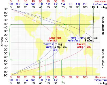
Length of a degree of longitude
The length of a degree of longitude (east–west distance) depends only on the radius of a circle of latitude. For a sphere of radius a that radius at latitude φ is a cos φ, and the length of a one-degree (or π/180 radian) arc along a circle of latitude is

| φ | Δ1 lat | Δ1 long |
|---|---|---|
| 0° | 110.574 km | 111.320 km |
| 15° | 110.649 km | 107.551 km |
| 30° | 110.852 km | 96.486 km |
| 45° | 111.133 km | 78.847 km |
| 60° | 111.412 km | 55.800 km |
| 75° | 111.618 km | 28.902 km |
| 90° | 111.694 km | 0.000 km |
When the Earth is modelled by an ellipsoid this arc length becomes[39][40]

where e, the eccentricity of the ellipsoid, is related to the major and minor axes (the equatorial and polar radii respectively) by

An alternative formula is
- ; here is the so-called parametric or reduced latitude.


Cos φ decreases from 1 at the equator to 0 at the poles, which measures how circles of latitude shrink from the equator to a point at the pole, so the length of a degree of longitude decreases likewise. This contrasts with the small (1%) increase in the length of a degree of latitude (north–south distance), equator to pole. The table shows both for the WGS84 ellipsoid with a = 6378137.0 m and b = 6356752.3142 m. Note that the distance between two points 1 degree apart on the same circle of latitude, measured along that circle of latitude, is slightly more than the shortest (geodesic) distance between those points (unless on the equator, where these are equal); the difference is less than 0.6 m (2 ft).
A geographical mile is defined to be the length of one minute of arc along the equator (one equatorial minute of longitude), therefore a degree of longitude along the equator is exactly 60 geographical miles or 111.3 kilometers, as there are 60 minutes in a degree. The length of 1 minute of longitude along the equator is 1 geographical mile or 1.855 km or 1.153 miles, while the length of 1 second of it is 0.016 geographical mile or 30.916 m or 101.43 feet.
Longitude on bodies other than Earth
Planetary coordinate systems are defined relative to their mean axis of rotation and various definitions of longitude depending on the body. The longitude systems of most of those bodies with observable rigid surfaces have been defined by references to a surface feature such as a crater. The north pole is that pole of rotation that lies on the north side of the invariable plane of the solar system (near the ecliptic). The location of the prime meridian as well as the position of the body's north pole on the celestial sphere may vary with time due to precession of the axis of rotation of the planet (or satellite). If the position angle of the body's prime meridian increases with time, the body has a direct (or prograde) rotation; otherwise the rotation is said to be retrograde.
In the absence of other information, the axis of rotation is assumed to be normal to the mean orbital plane; Mercury and most of the satellites are in this category. For many of the satellites, it is assumed that the rotation rate is equal to the mean orbital period. In the case of the giant planets, since their surface features are constantly changing and moving at various rates, the rotation of their magnetic fields is used as a reference instead. In the case of the Sun, even this criterion fails (because its magnetosphere is very complex and does not really rotate in a steady fashion), and an agreed-upon value for the rotation of its equator is used instead.
For planetographic longitude, west longitudes (i.e., longitudes measured positively to the west) are used when the rotation is prograde, and east longitudes (i.e., longitudes measured positively to the east) when the rotation is retrograde. In simpler terms, imagine a distant, non-orbiting observer viewing a planet as it rotates. Also suppose that this observer is within the plane of the planet's equator. A point on the Equator that passes directly in front of this observer later in time has a higher planetographic longitude than a point that did so earlier in time.
However, planetocentric longitude is always measured positively to the east, regardless of which way the planet rotates. East is defined as the counter-clockwise direction around the planet, as seen from above its north pole, and the north pole is whichever pole more closely aligns with the Earth's north pole. Longitudes traditionally have been written using "E" or "W" instead of "+" or "−" to indicate this polarity. For example, −91°, 91°W, +269° and 269°E all mean the same thing.
The reference surfaces for some planets (such as Earth and Mars) are ellipsoids of revolution for which the equatorial radius is larger than the polar radius, such that they are oblate spheroids. Smaller bodies (Io, Mimas, etc.) tend to be better approximated by triaxial ellipsoids; however, triaxial ellipsoids would render many computations more complicated, especially those related to map projections. Many projections would lose their elegant and popular properties. For this reason spherical reference surfaces are frequently used in mapping programs.
The modern standard for maps of Mars (since about 2002) is to use planetocentric coordinates. Guided by the works of historical astronomers, Merton E. Davies established the meridian of Mars at Airy-0 crater.[41][42] For Mercury, the only other planet with a solid surface visible from Earth, a thermocentric coordinate is used: the prime meridian runs through the point on the equator where the planet is hottest (due to the planet's rotation and orbit, the sun briefly retrogrades at noon at this point during perihelion, giving it more sun). By convention, this meridian is defined as exactly twenty degrees of longitude east of Hun Kal.[43][44][45]
Tidally-locked bodies have a natural reference longitude passing through the point nearest to their parent body: 0° the center of the primary-facing hemisphere, 90° the center of the leading hemisphere, 180° the center of the anti-primary hemisphere, and 270° the center of the trailing hemisphere.[46] However, libration due to non-circular orbits or axial tilts causes this point to move around any fixed point on the celestial body like an analemma.
See also
- American Practical Navigator
- Cardinal direction
- Ecliptic longitude
- Geodesy
- Geodetic system
- Geographic coordinate system
- Geographical distance
- Geotagging
- Great-circle distance
- History of longitude
- The Island of the Day Before
- Latitude
- Meridian arc
- Natural Area Code
- Navigation
- Orders of magnitude
- Right ascension on celestial sphere
- World Geodetic System
References
- "Definition of LONGITUDE". www.merriam-webster.com. Merriam-Webster. Retrieved 14 March 2018.
- Oxford English Dictionary
- Dicks, D.R. (1953). Hipparchus : a critical edition of the extant material for his life and works (PhD). Birkbeck College, University of London.
- Hoffman, Susanne M. (2016). "How time served to measure the geographical position since Hellenism". In Arias, Elisa Felicitas; Combrinck, Ludwig; Gabor, Pavel; Hohenkerk, Catherine; Seidelmann, P.Kenneth (eds.). The Science of Time. Astrophysics and Space Science Proceedings. 50. Springer International. pp. 25–36. doi:10.1007/978-3-319-59909-0_4. ISBN 978-3-319-59908-3.
- Mittenhuber, Florian (2010). "The Tradition of Texts and Maps in Ptolemy's Geography". In Jones, Alexander (ed.). Ptolemy in Perspective: Use and Criticism of his Work from Antiquity to the Nineteenth Century. Archimedes. 23. Dordrecht: Springer. pp. 95-119. doi:10.1007/978-90-481-2788-7_4. ISBN 978-90-481-2787-0.
- Bunbury, E.H. (1879). A History of Ancient Geography. 2. London: John Murray.
- Shcheglov, Dmitry A. (2016). "The Error in Longitude in Ptolemy's Geography Revisited". The Cartographic Journal. 53 (1): 3–14. doi:10.1179/1743277414Y.0000000098. S2CID 129864284.
- Wright, John Kirtland (1925). The geographical lore of the time of the Crusades: A study in the history of medieval science and tradition in Western Europe. New York: American geographical society.
- Ragep, F.Jamil (2010). "Islamic reactions to Ptolemy's imprecisions". In Jones, A. (ed.). Ptolemy in Perspective. Archimedes. 23. Dordrecht: Springer. doi:10.1007/978-90-481-2788-7. ISBN 978-90-481-2788-7.
- Tibbetts, Gerald R. (1992). "The Beginnings of a Cartographic Tradition" (PDF). In Harley, J.B.; Woodward, David (eds.). The History of Cartography Vol. 2 Cartography in the Traditional Islamic and South Asian Societies. University of Chicago Press.
- Said, S.S.; Stevenson, F.R. (1997). "Solar and Lunar Eclipse Measurements by Medieval Muslim Astronomers, II: Observations". Journal for the History of Astronomy. 28 (1): 29–48. Bibcode:1997JHA....28...29S. doi:10.1177/002182869702800103. S2CID 117100760.
- Steele, John Michael (1998). Observations and predictions of eclipse times by astronomers in the pre-telescopic period (PhD). University of Durham (United Kingdom).
- Wright, John Kirtland (1923). "Notes on the Knowledge of Latitudes and Longitudes in the Middle Ages". Isis. 5 (1). Bibcode:1922nkll.book.....W.
- Pickering, Keith (1996). "Columbus's Method of Determining Longitude: An Analytical View". The Journal of Navigation. 49 (1): 96–111. Bibcode:1996JNav...49...95P. doi:10.1017/S037346330001314X.
- Randles, W.G.L. (1985). "Portuguese and Spanish attempts to measure longitude in the 16th century". Vistas in Astronomy. 28 (1): 235–241. Bibcode:1985VA.....28..235R. doi:10.1016/0083-6656(85)90031-5.
- Pannekoek, Anton (1989). A history of astronomy. Courier Corporation. pp. 259–276.
- Van Helden, Albert (1974). "The Telescope in the Seventeenth Century". Isis. 65 (1): 38–58. doi:10.1086/351216. JSTOR 228880.
- Grimbergen, Kees (2004). Fletcher, Karen (ed.). Huygens and the advancement of time measurements. Titan - From Discovery to Encounter. Titan - from Discovery to Encounter. 1278. ESTEC, Noordwijk, Netherlands: ESA Publications Division. pp. 91–102. Bibcode:2004ESASP1278...91G. ISBN 92-9092-997-9.
- Blumenthal, Aaron S.; Nosonovsky, Michael (2020). "Friction and Dynamics of Verge and Foliot: How the Invention of the Pendulum Made Clocks Much More Accurate". Applied Mechanics. 1 (2): 111–122. doi:10.3390/applmech1020008.
- Olmsted, J.W. (1960). "The Voyage of Jean Richer to Acadia in 1670: A Study in the Relations of Science and Navigation under Colbert". Proceedings of the American Philosophical Society. 104 (6): 612–634. JSTOR 985537.
- See, for example, Port Royal, Jamaica: Halley, Edmond (1722). "Observations on the Eclipse of the Moon, June 18, 1722. and the Longitude of Port Royal in Jamaica". Philosophical Transactions. 32 (370–380): 235–236.; Buenos Aires: Halley, Edm. (1722). "The Longitude of Buenos Aires, Determin'd from an Observation Made There by Père Feuillée". Philosophical Transactions. 32 (370–380): 2–4.Santa Catarina, Brazil: Legge, Edward; Atwell, Joseph (1743). "Extract of a letter from the Honble Edward Legge, Esq; F. R. S. Captain of his Majesty's ship the Severn, containing an observation of the eclipse of the moon, Dec. 21. 1740. at the Island of St. Catharine on the Coast of Brasil". Philosophical Transactions. 42 (462): 18–19.
- Siegel, Jonathan R. (2009). "Law and Longitude". Tulane Law Review. 84: 1–66.
- Forbes, Eric Gray (2006). "Tobias Mayer's lunar tables". Annals of Science. 22 (2): 105–116. doi:10.1080/00033796600203075. ISSN 0003-3790.
- "There was no such thing as the Longitude Prize". Royal Museums Greenwich. 2012-03-07. Retrieved 2021-01-27.
- Wess, Jane (2015). "Navigation and Mathematics: A Match Made in the Heavens?". In Dunn, Richard; Higgitt, Rebekah (eds.). Navigational Enterprises in Europe and its Empires, 1730-1850. London: Palgrave Macmillan UK. pp. 201–222. doi:10.1057/9781137520647_11. ISBN 978-1-349-56744-7.
- Littlehales, G.W. (1909). "The Decline of the Lunar Distance for the Determination of the Time and Longitude at". Bulletin of the American Geographical Society. 41 (2): 83–86. doi:10.2307/200792. JSTOR 200792.
- Walker, Sears C (1850). "Report on the experience of the Coast Survey in regard to telegraph operations, for determination of longitude &c". American Journal of Science and Arts. 10 (28): 151–160.
- Knox, Robert W. (1957). "Precise Determination of Longitude in the United States". Geographical Review. 47: 555–563. JSTOR 211865.
- Green, Francis Mathews; Davis, Charles Henry; Norris, John Alexander (1883). Telegraphic Determination of Longitudes in Japan, China, and the East Indies: Embracing the Meridians of Yokohama, Nagasaki, Wladiwostok, Shanghai, Amoy, Hong-Kong, Manila, Cape St. James, Singapore, Batavia, and Madras, with the Latitude of the Several Stations. Washington: US Hydrographic Office.
- Munro, John (1902). "Time-Signals by Wireless Telegraphy". Nature. 66 (1713): 416. Bibcode:1902Natur..66..416M. doi:10.1038/066416d0. ISSN 0028-0836. S2CID 4021629.
- Hutchinson, D.L. (1908). "Wireless Time Signals from the St. John Observatory of the Canadian Meteorological Service". Proceedings and Transactions of the Royal Society of Canada. Ser. 3 Vol. 2: 153–154.
- Lockyer, William J. S. (1913). "International Time and Weather Radio-Telegraphic Signals". Nature. 91 (2263): 33–36. Bibcode:1913Natur..91...33L. doi:10.1038/091033b0. ISSN 0028-0836. S2CID 3977506.
- Zimmerman, Arthur E. "The first wireless time signals to ships at sea" (PDF). antiquewireless.org. Antique Wireless Association. Retrieved 9 July 2020.
- Pierce, J.A. (1946). "An introduction to Loran". Proceedings of the IRE. 34 (5): 216–234. doi:10.1109/JRPROC.1946.234564. S2CID 20739091.
- "Coordinate Conversion". colorado.edu. Archived from the original on 29 September 2009. Retrieved 14 March 2018.
- "λ = Longitude east of Greenwich (for longitude west of Greenwich, use a minus sign)."
John P. Snyder, Map Projections, A Working Manual, USGS Professional Paper 1395, page ix - NOAA ESRL Sunrise/Sunset Calculator (deprecated). Earth System Research Laboratory. Retrieved October 18, 2019.
- Read HH, Watson Janet (1975). Introduction to Geology. New York: Halsted. pp. 13–15.
- Osborne, Peter (2013). "Chapter 5: The geometry of the ellipsoid". The Mercator Projections: The Normal and Transverse Mercator Projections on the Sphere and the Ellipsoid with Full Derivations of all Formulae (PDF). Edinburgh. doi:10.5281/zenodo.35392. Archived from the original (PDF) on 2016-05-09. Retrieved 2016-01-24.
- Rapp, Richard H. (April 1991). "Chapter 3: Properties of the Ellipsoid". Geometric Geodesy Part I. Columbus, Ohio.: Department of Geodetic Science and Surveying, Ohio State University. hdl:1811/24333.
- Where is zero degrees longitude on Mars? – Copyright 2000 – 2010 © European Space Agency. All rights reserved.
- Davies, M. E., and R. A. Berg, "Preliminary Control Net of Mars,"Journal of Geophysical Research, Vol. 76, No. 2, pps. 373-393, January 10, 1971.
- Davies, M. E., "Surface Coordinates and Cartography of Mercury," Journal of Geophysical Research, Vol. 80, No. 17, June 10, 1975.
- Archinal, Brent A.; A'Hearn, Michael F.; Bowell, Edward L.; Conrad, Albert R.; et al. (2010). "Report of the IAU Working Group on Cartographic Coordinates and Rotational Elements: 2009". Celestial Mechanics and Dynamical Astronomy. 109 (2): 101–135. Bibcode:2011CeMDA.109..101A. doi:10.1007/s10569-010-9320-4. ISSN 0923-2958.
- "USGS Astrogeology: Rotation and pole position for the Sun and planets (IAU WGCCRE)". Archived from the original on October 24, 2011. Retrieved October 22, 2009.
- First map of extraterrestrial planet – Center of Astrophysics.
External links
- Resources for determining your latitude and longitude
- IAU/IAG Working Group On Cartographic Coordinates and Rotational Elements of the Planets and Satellites
- "Longitude forged": an essay exposing a hoax solution to the problem of calculating longitude, undetected in Dava Sobel's Longitude, from TLS, November 12, 2008.
- Board of Longitude Collection, Cambridge Digital Library – complete digital version of the Board's archive
- Longitude And Latitude Of Points of Interest
- Length Of A Degree Of Latitude And Longitude Calculator
- Esame critico intorno alla scoperta di Vespucci ...
- A land beyond the stars - Museo Galileo
| Key concepts |  | ||||||
|---|---|---|---|---|---|---|---|
| Measurement and standards |
| ||||||
| Clocks | |||||||
| |||||||
| |||||||
| Philosophy of time | |||||||
| Human experience and use of time |
| ||||||
| Time in |
| ||||||
| Related topics | |||||||
| |||||||
| International standards |
|  |
|---|---|---|
| Obsolete standards | ||
| Time in physics | ||
| Horology | ||
| Calendar | ||
| Archaeology and geology | ||
| Astronomical chronology | ||
| Other units of time | ||
| Related topics | ||