East Jakarta
East Jakarta (Indonesian: Jakarta Timur) is the largest of the five administrative cities (kota administrasi) which form the Special Capital Region of Jakarta, Indonesia. It had a population of 2,693,896 at the 2010 Census;[3] the latest official estimated population (as at mid 2019) is 2,937,859,[4] making it also the most populous of the five administrative cities within Jakarta. East Jakarta is not self-governed and does not have a city council, hence it is not classified as a proper municipality.
East Jakarta | |
|---|---|
| Administrative city of East Jakarta Kota Administrasi Jakarta Timur | |
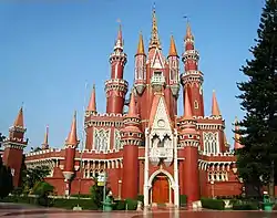 Taman Mini Indonesia Indah, East Jakarta | |
 Seal | |
 | |
| Country | |
| Province | |
| Government | |
| • Mayor | Muhammad Anwar |
| • Vice Mayor | Uus Kuswanto |
| Area | |
| • Total | 182.70 km2 (70.54 sq mi) |
| Population (2019)[2] | |
| • Total | 2,937,859 |
| • Density | 16,000/km2 (42,000/sq mi) |
| Time zone | UTC+7 (WIB) |
| Website | timur.jakarta.go.id |
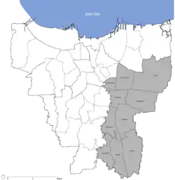
East Jakarta is bounded by North Jakarta to the north, Bekasi to the east, Depok to the south, and South Jakarta and Central Jakarta to the west.
The mayor's office is located in the Administrative Village (Kelurahan) of Pulo Gebang, in Cakung District.
Districts
East Jakarta is subdivided into ten districts (kecamatan), listed below with their areas and their populations at the 2010 Census and according to the mid-2019 official estimates:[5]
| District | Area (km²) | Population (2010 Census) |
Population (2019 Estimate) |
Population density 2019 (/km²) |
|---|---|---|---|---|
| Pasar Rebo | 12.98 | 189,232 | 221,158 | 17,038.4 |
| Ciracas | 16.08 | 251,757 | 300,345 | 18,678.2 |
| Cipayung | 28.45 | 228,536 | 282,360 | 9,924.8 |
| Makasar | 21.85 | 185,830 | 204,595 | 9,363.2 |
| Kramat Jati | 13.00 | 272,479 | 298,121 | 22,932.4 |
| Jatinegara | 10.25 | 266,734 | 275,903 | 26,917.4 |
| Duren Sawit | 22.65 | 384,748 | 399,595 | 17,642.2 |
| Cakung | 42.28 | 503,846 | 537,756 | 12,718.9 |
| Pulo Gadung | 15.61 | 262,328 | 266,199 | 17,053.1 |
| Matraman | 4.88 | 148,406 | 151,827 | 31,112.1 |
| Totals | 182.70 | 2,693,896 | 2,937,859 | 16,080.2 |
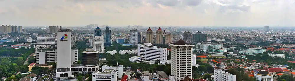
Economy
Aviastar Mandiri has its head office in East Jakarta.[6]
In the past, in East Jakarta, there are 23 Sugar mills such as Setu, Jatiwarna, Ceger, Kalijereng, Pedongkelan (Cimanggis), Palsigunung, Klender, Pondokjati and Cibubur is open in 1914 and is closed due to the 1997 Asian financial crisis.
The sugar mills were first open in Klender ((in Dutch): Suikerfabriek Klender) in 1905.
Transportation
- Halim Perdanakusuma International Airport serves a limited customer base; typically within an hour flight of the airport.[7]
- Kampung Rambutan Bus Terminal mainly provides service to inter-provincial, inter-city buses.
- Pulogebang inter-city and inter-province bus terminal, opened on June 23, 2012.[8]
References
- East Jakarta Government Officials List (in Indonesian)
- Badan Pusat Statistik, Jakarta, 2020.
- Biro Pusat Statistik, Jakarta, 2011.
- Badan Pusat Statiostik, Jakarta, 2020
- Badan Pusat Statistik, Jakarta, 2020.
- "Contact Us." (Archive) Aviastar. Retrieved on May 10, 2012. "Puri Sentra Niaga Blok B No. 29 Jalan Raya Kalimalang Jakarta Timur 13620 Indonesia"
- "Soekarno-Hatta must be expanded to meet passenger demand" ( Archived September 10, 2015, at the Wayback Machine). The Jakarta Post. Wednesday September 1, 2010. Retrieved on September 16, 2010. "Starting operation in 1985, Soekarno-Hatta airport replaced Kemayoran airport in Central Jakarta and Halim Perdanakusuma airport in East Jakarta"
- "Jakarta to Soft Open 'Most Modern' Bus Terminal on Saturday". June 22, 2012. Archived from the original on June 24, 2012. Retrieved June 22, 2012.
External links
| Wikimedia Commons has media related to East Jakarta. |
- (in Indonesian) Official site
 Jakarta/East travel guide from Wikivoyage