East Keansburg, New Jersey
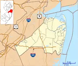
East Keansburg is an unincorporated community located within Middletown Township in Monmouth County, New Jersey, United States.[2] As the name suggests, the area is east of Keansburg with Route 36 bordering the south, Port Monmouth to the east across Pews Creek, and the Raritan Bay to the north. The community is included in the generalized North Middletown region of the township.
East Keansburg, New Jersey | |
|---|---|
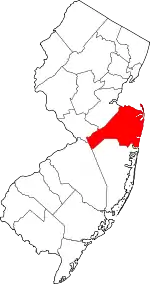
 East Keansburg, New Jersey Location of East Keansburg in Monmouth County Inset: Location of county within the state of New Jersey  East Keansburg, New Jersey East Keansburg, New Jersey (New Jersey)  East Keansburg, New Jersey East Keansburg, New Jersey (the United States) | |
| Coordinates: 40°26′20″N 74°07′01″W | |
| Country | |
| State | |
| County | Monmouth |
| Township | Middletown |
| Elevation | 7 ft (2 m) |
| GNIS feature ID | 882449[1] |
East Keansburg is surrounded by an earthen levee (known as "the dike") constructed as protection against flooding, during large storms such as Hurricane Sandy.[3]
The community includes the Tonya Keller Community Center, McMahon Park, and Ideal Beach along the bay. East Keansburg Fire Company #1 and Middletown Township First Aid & Rescue Squad are both located in East Keansburg. Portions of the Keansburg High School grounds are in Middletown/East Keansburg.
References
- "East Keansburg". Geographic Names Information System. United States Geological Survey.
- Locality Search, State of New Jersey. Accessed February 23, 2015.
- Morang, Andrew. "Hurricane Barriers in New England and New Jersey: History and Status after Five Decades", Journal of Coastal Research, Volume 32, Issue 1. Accessed June 8, 2016. "The U.S. Army Engineer District, New York (NAN), project is in Laurence Harbor (previously named Madison), Keansburg, and North Middletown (previously named East Keansburg) Townships, New Jersey, facing Raritan and Sandy Hook Bays."
