Hillsdale, Monmouth County, New Jersey
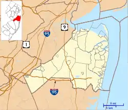
Hillsdale is an unincorporated community located within Colts Neck and Marlboro townships in Monmouth County, New Jersey, United States.[2] The community is located at the intersection of County Route 520 which runs east and west, Conover Road which heads north, and Boundary Road which heads south. The southeastern quadrant of this intersection is a part of Colts Neck while the other three are in Marlboro. The community is located atop a small hill and is largely rural. The Colts Neck quadrant is made up of a housing development while the Marlboro side is mostly forests, parkland, and the remains of the Marlboro Psychiatric Hospital.[3]
Hillsdale, New Jersey | |
|---|---|
 Looking west along CR 520 approaching Conover Road / Boundary Road | |
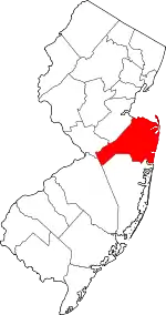
 Hillsdale, New Jersey Location of Hillsdale in Monmouth County Inset: Location of county within the state of New Jersey  Hillsdale, New Jersey Hillsdale, New Jersey (New Jersey)  Hillsdale, New Jersey Hillsdale, New Jersey (the United States) | |
| Coordinates: 40°20′21″N 74°13′31″W | |
| Country | |
| State | |
| County | Monmouth |
| Township | Colts Neck, Marlboro |
| Elevation | 233 ft (71 m) |
| GNIS feature ID | 877121[1] |
References
- "Hillsdale". Geographic Names Information System. United States Geological Survey.
- Locality Search, State of New Jersey. Accessed February 24, 2015.
- Google (April 23, 2016). "Aerial view of Hillsdale" (Map). Google Maps. Google. Retrieved April 23, 2016.
This article is issued from Wikipedia. The text is licensed under Creative Commons - Attribution - Sharealike. Additional terms may apply for the media files.