Stone Tavern, New Jersey
Stone Tavern is an unincorporated community located on the border of Millstone and Upper Freehold townships in Monmouth County, New Jersey, United States.[2]
Stone Tavern, New Jersey | |
|---|---|
 Stage Coach Road (CR 524) | |
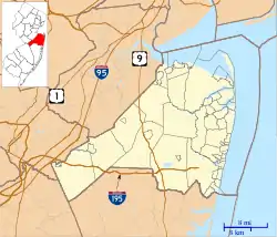 Stone Tavern, New Jersey Location of Stone Tavern in Monmouth County Inset: Location of county within the state of New Jersey  Stone Tavern, New Jersey Stone Tavern, New Jersey (New Jersey)  Stone Tavern, New Jersey Stone Tavern, New Jersey (the United States) | |
| Coordinates: 40°11′20″N 74°28′17″W | |
| Country | |
| State | |
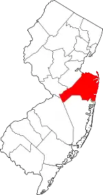
| County | Monmouth |
| Township | Millstone and Upper Freehold |
| Elevation | 210 ft (60 m) |
| Time zone | UTC-5 (Eastern (EST)) |
| • Summer (DST) | UTC-4 (EDT) |
| GNIS feature ID | 880930[1] |
The community took its name from a stone tavern once called Britton's Tavern.[3] Today the area, located along County Route 524 at the Millstone–Upper Freehold township line, consists mainly of single-family homes in forested rolling terrain.[4]
References
- "Stone Tavern". Geographic Names Information System. United States Geological Survey.
- Locality Search, State of New Jersey. Accessed March 4, 2015.
- History of Monmouth County, New Jersey, 1664-1920. Lewis Historical Publishing Company. 1922. p. 435.
- Google (August 29, 2015). "Aerial view of Stone Tavern" (Map). Google Maps. Google. Retrieved August 29, 2015.
This article is issued from Wikipedia. The text is licensed under Creative Commons - Attribution - Sharealike. Additional terms may apply for the media files.