Edenham
Edenham (/ˈɛdənəm/ EDD-ən-əm) is a village and civil parish in the South Kesteven district of Lincolnshire, England. It is approximately 3 miles (5 km) north-west of Bourne, and on the A151 road. While the civil parish is called "Edenham",[1] the parish council is called Edenham, Grimsthorpe, Elsthorpe & Scottlethorpe Parish Council.[2] The population of the civil parish at the 2011 census was 291.[3] The parish is principally located in the valley of the East Glen which flows through the village.
| Edenham | |
|---|---|
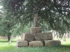 Remains of Saxon cross in Edenham churchyard, supported by newer blocks | |
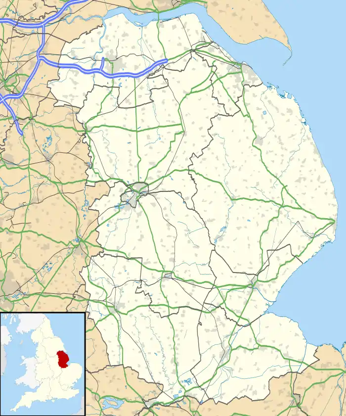 Edenham Location within Lincolnshire | |
| Population | 291 (2011) |
| OS grid reference | TF061218 |
| • London | 90 mi (140 km) S |
| Civil parish |
|
| District | |
| Shire county | |
| Region | |
| Country | England |
| Sovereign state | United Kingdom |
| Post town | BOURNE |
| Postcode district | PE10 |
| Dialling code | 01778 |
| Police | Lincolnshire |
| Fire | Lincolnshire |
| Ambulance | East Midlands |
| UK Parliament | |
Geology
The broad valley is incised into a gently sloping and much dissected plateau of glacial till which is more graphically described by the older term, boulder clay. The till caps the ridges to either side, the one clothed by the Bourne Woods and the other by the park of Grimsthorpe Castle. All the solid geology is Jurassic. The valley sides are of Kellaways clay, Kellaways sand and Oxford clay while its bottom is of cornbrash and Blisworth clay. In the south and west of the parish are much greater exposures of this solid geology with extensive areas of Blisworth Limestone and the Upper Estuarine Series. In the valley, there are also strips of alluvium and patches of glacial sand and gravel.[4]
Although Grimsthorpe Castle is on higher ground to the west, the village of Grimsthorpe shares the geology of the rest of the parish.[5]
Constituent settlements in the parish
The main village is:
- Edenham 52°47′02″N 0°25′40″W Edenham
The parish includes a number of outlying hamlets:
- Grimsthorpe 52°47′39″N 0°26′46″W
- Scottlethorpe 52°46′33″N 0°26′36″W
- Elsthorpe 52°48′10″N 0°25′50″W
The parish is associated with two lost settlements:
- Elsthorpe, 52°48′29″N 0°26′08″W[6] located near the modern hamlet of that name.
Aislestorp is mentioned in the Domesday Book of 1086 as belonging to Alfred of Lincoln and having a mill, 5 villagers, all Freemen; 2 ploughlands. 1 lord's plough team, 2 men's plough teams; 18 acres of Meadow, and 240 acres of Woodland.[7] Sunken roads, building plots, and a fishpond have been located at the site of the original settlement.[6] - Southorpe52°48′40″N 0°27′12″W.[8]
Sudtorp is mentioned in the Domesday Book as belonging to Guy of Craon and having a mill, 10 villagers, of whom 6 were smallholders; 2 ploughlands. 2 lord's plough teams, 2 men's plough teams; 16 acres of Meadow, and 200 acres of Woodland.[9] The village is mentioned from the time of the Domesday Survey onwards. There was a chantry chapel here in the 12th century. A priest was last instituted at Southorpe in 1521, and, by 1563, only one family remained.[8]
Administration
Once part of the Beltisloe Wapentake in Kesteven, the parish is now part of South Kesteven District. Its obligations under the 19th century poor law were undertaken by the Bourne Poor Law Union from 1835 onwards.[10]
The present electoral arrangements are as follows:[11]
- South Kesteven District Council, Glen Eden ward, Councillor Maureen Spencer-Gregson OBE[12]
- Lincolnshire County Council, Folkingham Rural ward, Councillor Martin Hill OBE[13]
- Westminster, Stamford and Grantham constituency, Gareth Davies MP[14]
- European Parliament, East Midlands, Derek Clark,[15] Roger Helmer,[16] Glenis Willmott,[17] Emma McClarkin,[18] Bill Newton Dunn[19]
The Ecclesiastical parish[20][21] follows the same boundaries, and is part of the Deanery of Beltisloe,[22] preserving the old Wapentake boundaries.
History
The Edenham name derives from the Anglo Saxon ham, meaning "homestead". The rest of the name probably derives from dene, a "vale in woodland" and ea, "river", though "Eada's homestead" and "Eada's hemmed-in-land" have also been suggested.[23] The river East Glen which flows through it is sometimes called the "Eden" by a process of back-formation from the name of the village.
Edenham appears in the Domesday Book as having 32 villagers, 4 smallholders, 24 freemen, 5 lord's plough teams, and 9 men's plough teams, with 400 acres (1.6 km2) of woodland and 29 acres of meadow.[24]
The parish was the site of the Cistercian abbey of Vaudey, founded in 1147 by William, Earl of Albemarle. It was dissolved during the 1536 Suppression.[25]
Documents of 1307 mention the existence in Edenham of "a hospital".[26]
Since 1516 parish land and villages have been owned by the de Eresby family of Grimsthorpe Castle. This major ancestral seat 2 miles (3.2 km) to the north-west of the village influenced Edenham's estate village character. The de Eresby baronetcy has continued in an unbroken line since 1313, and heads of the family have been Earls and Dukes of Ancaster and the Earl of Lindsey.
The 19th-century Baron Willoughby de Eresby built the Edenham and Little Bytham Railway which connected the village to the East Coast Main Line at Little Bytham.[27] Apart from crossing a road in near Little Bytham station, it ran exclusively on his estate.
The Australian poet and novelist Frederic Manning stayed at the vicarage after he arrived in the country in 1903. He returned there after the First World War and began writing The Middle Parts of Fortune (republished in an expurgated version under the title Her Privates We), a novel which he completed in the neighbouring parish, Bourne.
Community
The Grade I listed[28] church retains some Anglo-Saxon fabric from the earlier building. The Saxon church was dedicated to the 'Holy Cross', but the dedication is now to St Michael, or St Michael and all Angels. It has an Angel Roof, the beams supported on the back of carved and painted angels.[28] Family monuments were moved from St Matthew's church in Normanton[28] when that church was affected by the construction of Rutland Water.
The ecclesiastical parish is Edenham. The church, dedicated to St Michael and all Angels, is part of the Edenham with Witham On The Hill Group of the Beltisloe Deanery of the Diocese of Lincoln. The 2013 incumbent is Rev Canon Andrew Hawes.[29]
The vicarage, unlike other vicarages and rectories in rural parishes, has never been sold to a private buyer. It remains the spiritual centre of three parishes and eight small villages, and is run by the Diocese of Lincoln as a retreat for contemplation and prayer.[30]
A cedar tree overhangs the road from the churchyard, and nearby are the remains of a Saxon cross, a Grade II listed building[31] and Scheduled Monument.[32]
The village Church of England primary school, also a Grade II listed building,[33] has a roll of just over one hundred pupils.[34]
Apart from agricultural employers, businesses in the village include The Five Bells public house and the local school. The coal merchant and post office having closed
Businesses
Apart from agricultural employers there are a pub, school and agricultural dealer.
References
- "Edenham". Mapit. Retrieved 12 August 2018.
- "Parish council details".
- "Civil Parish population 2011". Neighbourhood Statistics. Office for National Statistics. Retrieved 16 May 2016.
- Institute of Geological Sciences Geological Maps of England and Wales One-Inch Series Sheet 143 (1967)
- "BGS map mashup of geological information". Archived from the original on 27 July 2011. - can be zoomed to show the villages
- Historic England. "Elsthorpe (348468)". PastScape. Retrieved 10 April 2010.
- Domesday Survey.
Aislestorp
- Historic England. "Southorpe (348516)". PastScape. Retrieved 15 February 2011.
- Domesday Survey.
Sudthorp
- "Private web site dealling with history of the Bourne poor law union". Retrieved 15 February 2011.
- "Unofficial web site simmarising local representatives". Retrieved 15 February 2011.
- Maureen Spencer-Gregson OBE
- Martin Hill OBE
- "Mr Nicholas Boles". 9 June 2010. Archived from the original on 9 June 2010. Retrieved 6 April 2020.
- Derek Clark
- Roger Helmer
- Glenis Willmott
- Emma McClarkin
- Bill Newton Dunn
- "Eclesiastical parish details". Archived from the original on 16 July 2011. Retrieved 2011-02-15.
- "Eclesiastical parish web site". Retrieved 15 February 2011.
- "Deanery details, Diocesan web site". Archived from the original on 16 July 2011. Retrieved 15 February 2011.
- "Notes about the place name". Archived from the original on 30 January 2010.CS1 maint: bot: original URL status unknown (link)
- "Modern map-based Domesday extracts". Archived from the original on 13 March 2012. Retrieved 15 February 2011.
- Cox, J. Charles (1916) Lincolnshire p. 120; Methuen & Co. Ltd
- Historic England. "Hospital (1345164)". PastScape. Retrieved 4 July 2010.
- Pearson, R.E & Ruddock, J.G. Lord Willoughby's Railway the Edenham Branch (1986) ISBN 0-9511656-0-7
- Historic England. "Church of St. Michael and All Angels (Grade I) (1146587)". National Heritage List for England. Retrieved 21 July 2016.
- "Edenham P C C". Archived from the original on 16 July 2011., Diocese of Lincoln
- "Web site for Edenham Regional House (vicarage)". Archived from the original on 19 June 2010.
- Historic England. "Churchyard cross 5 metres south west of Church of St. Michael (Grade II) (1146650)". National Heritage List for England. Retrieved 21 July 2016.
- Historic England. "Churchyard cross, St Michael's churchyard (1009202)". National Heritage List for England. Retrieved 21 July 2016.
- Historic England. "Primary School (Grade II) (1062832)". National Heritage List for England. Retrieved 25 July 2016.
- "School Web Site".
External links
 Media related to Edenham at Wikimedia Commons
- "Welcome to St Michael's & All Angels, Edenham", forwardinfaithlincs.org.uk. Retrieved 26 July 2011
- http://www.greatenglishchurches.co.uk/html/edenham.html
- "Edenham. Church: St Michael", robschurches.moonfruit.com. Retrieved 26 July 2011
- "St Michael, Edenham, Lincolnshire", The Corpus of Romanesque Sculpture in Britain and Ireland. Retrieved 26 July 2011
- "The Parliamentary Gazetteer’s Summary of Edenham, 1843.", boar.org.uk. Retrieved 26 July 2011
- "Edenham", homepages.which.net. Retrieved 26 July 2011
- Geanealogy web site references to the parish
- Another general historic resource
- Another general history site
- Map of parish boundaries
- Official list of MEPs
England Portal | |
| Unitary authorities | |
| Boroughs or districts | |
| Major settlements |
|
| Topics | |
