Erskine, Oregon
Erskine is an unincorporated community in Sherman County, in the U.S. state of Oregon.[1] It lies between Moro and Grass Valley along Erskine Road, west of U.S. Route 97.[2][3]
Erskine, Oregon | |
|---|---|
 Erskine, Oregon  Erskine, Oregon | |
| Coordinates: 45°26′17″N 120°46′43″W | |
| Country | United States |
| State | Oregon |
| County | Sherman |
| Elevation | 2,162 ft (659 m) |
| Time zone | UTC-8 (Pacific (PST)) |
| • Summer (DST) | UTC-7 (PDT) |
| Area code(s) | 458 and 541 |
| GNIS feature ID | 1167703[1] |
Erskine at various times was known by other names: Erskineville, Erskine Springs, and Millra.[4] An Erskineville post office was established here in 1882; Abiel Erskine was the first postmaster.[4] The Columbia Southern Railway called the place Erskineville in 1900 when it built its line through this community, but the Union Pacific later shortened that to Erskine.[4] The Erskineville post office closed in 1907.[4] Erskine is the name that appears on maps in the 21st century.[2]
References
- "Erskine". Geographic Names Information System. United States Geological Survey. November 28, 1980. Retrieved November 3, 2016.
- "Erskine". ACME Labs. Retrieved November 3, 2016 – via ACME Mapper.
- Oregon Atlas & Gazetteer (7th ed.). Yarmouth, Maine: DeLorme. 2008. p. 72. ISBN 978-0-89933-347-2.
- McArthur, Lewis A.; McArthur, Lewis L. (2003) [1928]. Oregon Geographic Names (7th ed.). Portland, Oregon: Oregon Historical Society Press. p. 334. ISBN 978-0875952772.
Municipalities and communities of Sherman County, Oregon, United States | ||
|---|---|---|
| Cities | 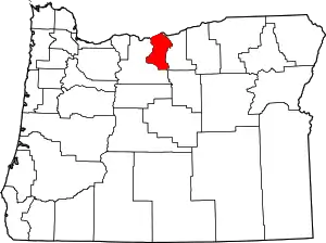 Sherman County map | |
| CDP | ||
| Other communities | ||
| Indian reservation | ||
| Footnotes | ‡This populated place also has portions in an adjacent county or counties | |
| ||
This article is issued from Wikipedia. The text is licensed under Creative Commons - Attribution - Sharealike. Additional terms may apply for the media files.