Sherman County, Oregon
Sherman County is one of the 36 counties in the U.S. state of Oregon. As of the 2010 census, the population was 1,765,[1] making it the second-least populous county in Oregon. The county seat is Moro,[2] and the largest city is Wasco. The county is named for William Tecumseh Sherman, a Union general in the American Civil War.
Sherman County | |
|---|---|
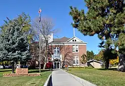 Sherman County Courthouse in Moro | |
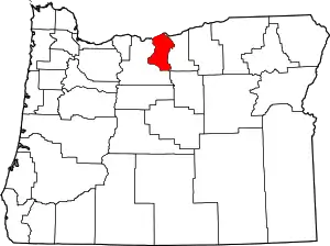 Location within the U.S. state of Oregon | |
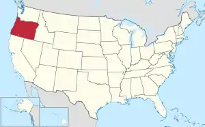 Oregon's location within the U.S. | |
| Coordinates: 45°25′N 120°41′W | |
| Country | |
| State | |
| Founded | February 25, 1889 |
| Seat | Moro |
| Largest city | Wasco |
| Area | |
| • Total | 831 sq mi (2,150 km2) |
| • Land | 824 sq mi (2,130 km2) |
| • Water | 7.5 sq mi (19 km2) 0.9%% |
| Population (2010) | |
| • Total | 1,765 |
| • Estimate (2019) | 1,780 |
| • Density | 2.1/sq mi (0.8/km2) |
| Time zone | UTC−8 (Pacific) |
| • Summer (DST) | UTC−7 (PDT) |
| Congressional district | 2nd |
| Website | co |
History
_(sheDB0149).jpg.webp)
_(sheD0049).jpg.webp)
_(sheD0041).jpg.webp)
As the pioneers felt crowded in the new settlements of western Oregon, they turned east to the Columbia Plateau for new opportunities. The county's first white settler was William Graham, who located at the mouth of the Deschutes River in 1858.[3] Homesteaders, eager for land, arrived in the 1880s by steamboat, stagecoach and wagon. Soon farmers received government patents.
As the population grew, so did the sentiment for independence from Wasco County.[3] Sherman County was created on February 25, 1889, out of the northeast corner of Wasco County. The county's borders have been changed only once, in 1891, when the Legislative Assembly moved the county line 18 miles (29 km) farther south into Wasco County.
The town of Wasco was designated the county seat by the Legislative Assembly although this designation was contested between Wasco and Moro. Following the addition of a portion of Wasco County, Moro became the eventual winner.
Geography
According to the U.S. Census Bureau, the county has a total area of 831 square miles (2,150 km2), of which 824 square miles (2,130 km2) is land and 7.5 square miles (19 km2) (0.9%) is water.[4]
Adjacent counties
- Klickitat County, Washington - north
- Gilliam County - east
- Wasco County - southwest
Demographics
| Historical population | |||
|---|---|---|---|
| Census | Pop. | %± | |
| 1890 | 1,792 | — | |
| 1900 | 3,477 | 94.0% | |
| 1910 | 4,242 | 22.0% | |
| 1920 | 3,826 | −9.8% | |
| 1930 | 2,978 | −22.2% | |
| 1940 | 2,321 | −22.1% | |
| 1950 | 2,271 | −2.2% | |
| 1960 | 2,446 | 7.7% | |
| 1970 | 2,139 | −12.6% | |
| 1980 | 2,172 | 1.5% | |
| 1990 | 1,918 | −11.7% | |
| 2000 | 1,934 | 0.8% | |
| 2010 | 1,765 | −8.7% | |
| 2019 (est.) | 1,780 | [5] | 0.8% |
| U.S. Decennial Census[6] 1790-1960[7] 1900-1990[8] 1990-2000[9] 2010-2019[1] | |||
2000 census
As of the census[10] of 2000, there were 1,934 people, 797 households, and 545 families living in the county. The population density was 2 people per square mile (1/km2). There were 935 housing units at an average density of 1 per square mile (0/km2). The racial makeup of the county was 93.59% White, 0.21% Black or African American, 1.40% Native American, 0.47% Asian, 2.79% from other races, and 1.55% from two or more races. 4.86% of the population were Hispanic or Latino of any race. 20.5% were of German, 17.3% American, 11.7% English, 8.7% Irish and 5.3% Norwegian ancestry.
There were 797 households, out of which 29.90% had children under the age of 18 living with them, 58.50% were married couples living together, 6.50% had a female householder with no husband present, and 31.50% were non-families. 28.70% of all households were made up of individuals, and 14.10% had someone living alone who was 65 years of age or older. The average household size was 2.43 and the average family size was 2.97.
In the county, the population was spread out, with 26.40% under the age of 18, 5.80% from 18 to 24, 23.40% from 25 to 44, 26.10% from 45 to 64, and 18.30% who were 65 years of age or older. The median age was 42 years. For every 100 females there were 102.90 males. For every 100 females age 18 and over, there were 105.00 males.
The median income for a household in the county was $35,142, and the median income for a family was $42,563. Males had a median income of $31,207 versus $21,579 for females. The per capita income for the county was $17,448. About 12.30% of families and 14.60% of the population were below the poverty line, including 20.20% of those under age 18 and 7.70% of those age 65 or over.
2010 census
As of the 2010 United States Census, there were 1,765 people, 777 households, and 492 families living in the county.[11] The population density was 2.1 inhabitants per square mile (0.81/km2). There were 918 housing units at an average density of 1.1 per square mile (0.42/km2).[12] The racial makeup of the county was 93.4% white, 1.6% American Indian, 0.2% black or African American, 0.2% Asian, 0.1% Pacific islander, 2.7% from other races, and 1.8% from two or more races. Those of Hispanic or Latino origin made up 5.6% of the population.[11] In terms of ancestry, 22.6% were German, 16.5% were English, 13.0% were Irish, and 4.9% were American.[13]
Of the 777 households, 23.0% had children under the age of 18 living with them, 51.2% were married couples living together, 7.5% had a female householder with no husband present, 36.7% were non-families, and 30.5% of all households were made up of individuals. The average household size was 2.27 and the average family size was 2.84. The median age was 48.2 years.[11]
The median income for a household in the county was $41,354 and the median income for a family was $52,361. Males had a median income of $42,768 versus $32,386 for females. The per capita income for the county was $21,688. About 13.9% of families and 20.0% of the population were below the poverty line, including 38.2% of those under age 18 and 9.9% of those age 65 or over.[14]
Government and infrastructure
The Northern Oregon Regional Corrections Facility (Norcor), a short-term jail, serves Sherman, Gilliam, Hood River, and Wasco counties.[15]
| Year | Republican | Democratic | Third parties |
|---|---|---|---|
| 2016 | 72.0% 732 | 19.9% 202 | 8.2% 83 |
| 2012 | 66.1% 678 | 31.1% 319 | 2.8% 29 |
| 2008 | 60.6% 634 | 36.8% 385 | 2.7% 28 |
| 2004 | 62.9% 694 | 35.3% 390 | 1.8% 20 |
| 2000 | 63.9% 679 | 30.7% 326 | 5.4% 57 |
| 1996 | 44.6% 476 | 41.6% 444 | 13.8% 147 |
| 1992 | 38.0% 424 | 32.4% 362 | 29.6% 330 |
| 1988 | 54.6% 555 | 42.8% 435 | 2.6% 26 |
| 1984 | 67.5% 828 | 32.4% 398 | 0.1% 1 |
| 1980 | 57.9% 677 | 33.3% 389 | 8.9% 104 |
| 1976 | 51.1% 567 | 44.3% 491 | 4.6% 51 |
| 1972 | 64.9% 677 | 31.6% 330 | 3.5% 36 |
| 1968 | 59.3% 646 | 35.3% 384 | 5.4% 59 |
| 1964 | 36.5% 494 | 63.5% 859 | 0.0% 0 |
| 1960 | 56.6% 659 | 43.4% 506 | 0.0% 0 |
| 1956 | 61.5% 671 | 38.5% 420 | 0.0% 0 |
| 1952 | 67.5% 747 | 32.1% 355 | 0.5% 5 |
| 1948 | 53.2% 532 | 45.4% 454 | 1.4% 14 |
| 1944 | 47.7% 475 | 52.0% 518 | 0.3% 3 |
| 1940 | 46.1% 575 | 53.7% 670 | 0.2% 3 |
| 1936 | 27.8% 337 | 67.9% 823 | 4.4% 53 |
| 1932 | 38.0% 423 | 59.8% 665 | 2.2% 24 |
| 1928 | 66.4% 759 | 32.8% 375 | 0.9% 10 |
| 1924 | 55.9% 756 | 27.1% 367 | 16.9% 229 |
| 1920 | 65.6% 893 | 31.1% 423 | 3.4% 46 |
| 1916 | 46.9% 717 | 48.8% 747 | 4.3% 66 |
| 1912 | 34.9% 244 | 33.1% 232 | 32.0% 224 |
| 1908 | 58.3% 437 | 33.6% 252 | 8.1% 61 |
| 1904 | 71.1% 701 | 16.5% 163 | 12.4% 122 |
Economy
Sherman County is predominantly an agricultural county, its economy receiving some aid from ranching and tourism. Its farms primarily produce wheat and barley. It is also home to the Biglow Canyon Wind Farm, the largest project of its kind in Oregon.[17]
Communities
Cities
- Grass Valley
- Moro (county seat)
- Rufus
- Wasco
Census-designated place
Other unincorporated communities
Footnotes
- "State & County QuickFacts". United States Census Bureau. Retrieved November 15, 2013.
- "Find a County". National Association of Counties. Retrieved June 7, 2011.
- In the beginning, Sherman County Historical Society and Museum
- "2010 Census Gazetteer Files". United States Census Bureau. August 22, 2012. Retrieved February 28, 2015.
- "Population and Housing Unit Estimates". Retrieved March 26, 2020.
- "U.S. Decennial Census". United States Census Bureau. Retrieved February 28, 2015.
- "Historical Census Browser". University of Virginia Library. Retrieved February 28, 2015.
- Forstall, Richard L., ed. (March 27, 1995). "Population of Counties by Decennial Census: 1900 to 1990". United States Census Bureau. Retrieved February 28, 2015.
- "Census 2000 PHC-T-4. Ranking Tables for Counties: 1990 and 2000" (PDF). United States Census Bureau. April 2, 2001. Retrieved February 28, 2015.
- "U.S. Census website". United States Census Bureau. Retrieved January 31, 2008.
- "DP-1 Profile of General Population and Housing Characteristics: 2010 Demographic Profile Data". United States Census Bureau. Archived from the original on February 13, 2020. Retrieved February 23, 2016.
- "Population, Housing Units, Area, and Density: 2010 - County". United States Census Bureau. Archived from the original on February 13, 2020. Retrieved February 23, 2016.
- "DP02 SELECTED SOCIAL CHARACTERISTICS IN THE UNITED STATES – 2006-2010 American Community Survey 5-Year Estimates". United States Census Bureau. Archived from the original on February 13, 2020. Retrieved February 23, 2016.
- "DP03 SELECTED ECONOMIC CHARACTERISTICS – 2006-2010 American Community Survey 5-Year Estimates". United States Census Bureau. Archived from the original on February 13, 2020. Retrieved February 23, 2016.
- "Norcor Home Archived November 24, 2011, at the Wayback Machine." Northern Oregon Regional Corrections Facility. Retrieved on November 22, 2011.
- Leip, David. "Dave Leip's Atlas of U.S. Presidential Elections". uselectionatlas.org. Retrieved April 11, 2018.
- Hill, Gail Kinsey. Wind farm in gorge may blow others away. The Oregonian. August 1, 2005.
Further reading
- Giles French, The Golden land : a history of Sherman County, Oregon.Portland, OR: Champoeg Press, 1958.
- Sherman County Historical Society, A Guide to Oregon Trails in Sherman County, Oregon. Moro, OR: Sherman County Historical Society, 1993.
- An Illustrated History of Central Oregon, Embracing Wasco, Sherman, Gilliam, Wheeler, Crook, Lake, and Klamath Counties, State of Oregon. Spokane, WA: Western Historical Publishing Co., 1905.
Newspapers
- Moro Bulletin.
- Moro Leader. (1898— )
- Moro Observer/Sherman County Observer. (1897—1931)
- Sherman County Journal. (1931— )
- Sherman County News. (1927— )
Places adjacent to Sherman County, Oregon | ||||||||||
|---|---|---|---|---|---|---|---|---|---|---|
| ||||||||||
Municipalities and communities of Sherman County, Oregon, United States | ||
|---|---|---|
| Cities | Sherman County map | |
| CDP | ||
| Other communities | ||
| Indian reservation | ||
| Footnotes | ‡This populated place also has portions in an adjacent county or counties | |
| ||

| Authority control |
|---|