Etowah, Arkansas
Etowah is a town in Mississippi County, Arkansas, United States. The population was 366 at the 2000 census.
Etowah, Arkansas | |
|---|---|
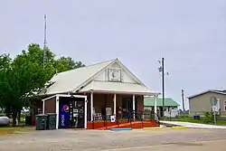 Town Hall in Etowah | |
 Location of Etowah in Mississippi County, Arkansas. | |
| Coordinates: 35°43′2″N 90°13′19″W | |
| Country | United States |
| State | Arkansas |
| County | Mississippi |
| Seat | Etowah Town Hall |
| Government | |
| • Type | Mayor - Council Government |
| • Mayor | Bo McCullom (IND) |
| Area | |
| • Total | 5.94 sq mi (15.39 km2) |
| • Land | 5.94 sq mi (15.38 km2) |
| • Water | 0.01 sq mi (0.01 km2) |
| Elevation | 230 ft (70 m) |
| Population (2010) | |
| • Total | 351 |
| • Estimate (2019)[2] | 317 |
| • Density | 53.38/sq mi (20.61/km2) |
| Time zone | UTC-6 (Central (CST)) |
| • Summer (DST) | UTC-5 (CDT) |
| ZIP code | 72428 |
| Area code(s) | 870 |
| FIPS code | 05-22120 |
| GNIS feature ID | 0057729 |
History, Elections, & Government
Etowah began as a settlement established for workers of the Chapman and Dewey Lumber Company in the 1890s. When a post office was established in 1902, the name "Etowah" was chosen after several other names had been rejected by the postal service. Etowah incorporated as a town in 1996.[3]
There have been very few people to run against Mayor Bo, which most election years he runs un-opposed. The City Council holds elections for members, but most of the council gets re-elected.
The Etowah Government is made out of the Office of the Mayor, and the City Council. The Council has 7 Voting members, plus the Mayor. The Council mostly votes accordingly to the Major. There has been very few changes in the Towns government, because the seat-holders always run un-opposed.
Geography
Etowah is located at 35°43′2″N 90°13′19″W (35.717221, -90.221893).[4] The town is concentrated along Arkansas Highway 136 northeast of Lepanto and south of Manila. Etowah's municipal boundaries stretch southward to Arkansas Highway 140 and eastward to Arkansas Highway 77. Little River passes through the southeastern part of the town.
According to the United States Census Bureau, the town has a total area of 15.3 km2 (5.9 mi2), all land.
Demographics
| Historical population | |||
|---|---|---|---|
| Census | Pop. | %± | |
| 2000 | 366 | — | |
| 2010 | 351 | −4.1% | |
| 2019 (est.) | 317 | [2] | −9.7% |
| U.S. Decennial Census[5] 2014 Estimate[6] | |||
As of the 2010 United States Census, there were 351 people living in the town. The racial makeup of the town was 89.5% White, 1.1% Black, 0.3% Asian and 2.0% from two or more races. 7.1% were Hispanic or Latino of any race.
As of the census[7] of 2000, there were 366 people, 137 households, and 106 families living in the town. The population density was 24.0/km2 (62.1/mi2). There were 153 housing units at an average density of 10.0/km2 (26.0/mi2). The racial makeup of the town was 94.81% White, 1.37% Black or African American, 1.64% Native American, 0.55% from other races, and 1.64% from two or more races. 0.82% of the population were Hispanic or Latino of any race.
There were 137 households, out of which 36.5% had children under the age of 18 living with them, 60.6% were married couples living together, 11.7% had a female householder with no husband present, and 22.6% were non-families. 18.2% of all households were made up of individuals, and 6.6% had someone living alone who was 65 years of age or older. The average household size was 2.67 and the average family size was 3.07.
In the town, the population was spread out, with 28.1% under the age of 18, 7.4% from 18 to 24, 31.1% from 25 to 44, 21.9% from 45 to 64, and 11.5% who were 65 years of age or older. The median age was 34 years. For every 100 females, there were 94.7 males. For every 100 females age 18 and over, there were 105.5 males.
The median income for a household in the town was $21,563, and the median income for a family was $23,750. Males had a median income of $19,643 versus $17,679 for females. The per capita income for the town was $8,890. About 13.3% of families and 19.1% of the population were below the poverty line, including 20.5% of those under age 18 and 23.6% of those age 65 or over.
Education
The Manila School District operates area public schools. The Etowah School District consolidated into the Manila district on July 1, 1986.[8]
References
- "2019 U.S. Gazetteer Files". United States Census Bureau. Retrieved June 30, 2020.
- "Population and Housing Unit Estimates". United States Census Bureau. May 24, 2020. Retrieved May 27, 2020.
- Steven Teske, "Etowah (Mississippi County)," Encyclopedia of Arkansas History and Culture, 2016.
- "US Gazetteer files: 2010, 2000, and 1990". United States Census Bureau. 2011-02-12. Retrieved 2011-04-23.
- "Census of Population and Housing". Census.gov. Retrieved June 4, 2015.
- "Annual Estimates of the Resident Population for Incorporated Places: April 1, 2010 to July 1, 2014". Archived from the original on May 22, 2015. Retrieved June 4, 2015.
- "U.S. Census website". United States Census Bureau. Retrieved 2008-01-31.
- "ConsolidationAnnex_from_1983.xls." Arkansas Department of Education. Retrieved on October 13, 2017.
External links
 Media related to Etowah, Arkansas at Wikimedia Commons
Municipalities and communities of Mississippi County, Arkansas, United States | ||
|---|---|---|
| Cities | 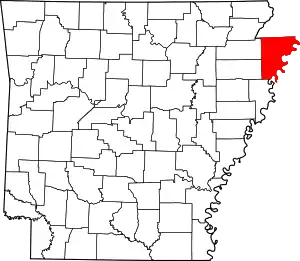 Map of Arkansas highlighting Mississippi County | |
| Towns | ||
| Unincorporated communities |
| |
| Footnotes | ‡This populated place also has portions in an adjacent county or counties | |
| ||