Mississippi County, Arkansas
Mississippi County is a county located in the U.S. state of Arkansas. As of the 2010 census, the population was 46,480.[1] There are two county seats, Blytheville and Osceola.[2] The county was formed on November 1, 1833, and named for the Mississippi River which borders the county to the east. Mississippi County is part of the First Congressional District in Arkansas. The Mississippi County Judge is John Alan Nelson.
Mississippi County | |
|---|---|
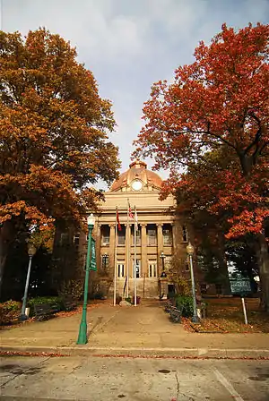 Mississippi County Courthouse, Osceola | |
 Flag | |
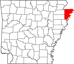 Location within the U.S. state of Arkansas | |
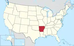 Arkansas's location within the U.S. | |
| Coordinates: 35°46′36″N 90°03′16″W | |
| Country | |
| State | |
| Founded | November 1, 1833 |
| Named for | Mississippi River |
| Seat | Blytheville and Osceola |
| Largest city | Blytheville |
| Area | |
| • Total | 920 sq mi (2,400 km2) |
| • Land | 901 sq mi (2,330 km2) |
| • Water | 19 sq mi (50 km2) 2.1%% |
| Population (2010) | |
| • Total | 46,480 |
| • Estimate (2019) | 40,651 |
| • Density | 51/sq mi (20/km2) |
| Time zone | UTC−6 (Central) |
| • Summer (DST) | UTC−5 (CDT) |
| Congressional district | 1st |
| Website | www |
The Blytheville, AR Micropolitan Statistical Area includes all of Mississippi County.
Geography
According to the U.S. Census Bureau, the county has a total area of 920 square miles (2,400 km2), of which 901 square miles (2,330 km2) is land and 19 square miles (49 km2) (2.1%) is water.[3]
Major highways
.svg.png.webp) Interstate 55
Interstate 55 U.S. Highway 61
 Highway 14
 Highway 18
 Highway 18 Business
 Highway 77
 Highway 118
 Highway 119
 Highway 135
 Highway 136
 Highway 137
 Highway 137 Spur
 Highway 140
 Highway 150
 Highway 151
 Highway 158
 Highway 181
 Highway 239
 Highway 239 Spur
 Highway 947
Adjacent counties
- Dunklin County, Missouri (northwest)
- Pemiscot County, Missouri (north)
- Dyer County, Tennessee (northeast)
- Lauderdale County, Tennessee (east)
- Tipton County, Tennessee (southeast)
- Crittenden County (south)
- Poinsett County (southwest)
- Craighead County (west)
National protected area
Demographics
| Historical population | |||
|---|---|---|---|
| Census | Pop. | %± | |
| 1840 | 1,410 | — | |
| 1850 | 2,368 | 67.9% | |
| 1860 | 3,895 | 64.5% | |
| 1870 | 3,633 | −6.7% | |
| 1880 | 7,332 | 101.8% | |
| 1890 | 11,635 | 58.7% | |
| 1900 | 16,384 | 40.8% | |
| 1910 | 30,468 | 86.0% | |
| 1920 | 47,320 | 55.3% | |
| 1930 | 69,289 | 46.4% | |
| 1940 | 80,217 | 15.8% | |
| 1950 | 82,375 | 2.7% | |
| 1960 | 70,174 | −14.8% | |
| 1970 | 62,060 | −11.6% | |
| 1980 | 59,517 | −4.1% | |
| 1990 | 57,525 | −3.3% | |
| 2000 | 51,979 | −9.6% | |
| 2010 | 46,480 | −10.6% | |
| 2019 (est.) | 40,651 | [4] | −12.5% |
| U.S. Decennial Census[5] 1790–1960[6] 1900–1990[7] 1990–2000[8] 2010–2016[1] | |||
As of the 2010 census, there were 46,480 people living in the county. The racial makeup of the county was 60.5% White, 33.9% Black, 0.3% Native American, 0.5% Asian, <0.0% Pacific Islander, 0.1% from some other race and 1.2% from two or more races. 3.6% were Hispanic or Latino of any race.
As of the 2000 census,[10] there were 51,979 people, 19,349 households, and 13,911 families living in the county. The population density was 58 people per square mile (22/km2). There were 22,310 housing units at an average density of 25 per square mile (10/km2). The racial makeup of the county was 64.45% White, 32.70% Black or African American, 0.26% Native American, 0.38% Asian, 0.03% Pacific Islander, 1.07% from other races, and 1.12% from two or more races. 2.25% of the population were Hispanic or Latino of any race.
There were 19,349 households, out of which 36.00% had children under the age of 18 living with them, 50.00% were married couples living together, 17.40% had a female householder with no husband present, and 28.10% were non-families. 24.70% of all households were made up of individuals, and 10.70% had someone living alone who was 65 years of age or older. The average household size was 2.64 and the average family size was 3.15.
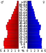
In the county, the population was spread out, with 29.60% under the age of 18, 9.90% from 18 to 24, 27.50% from 25 to 44, 20.80% from 45 to 64, and 12.20% who were 65 years of age or older. The median age was 33 years. For every 100 females there were 91.80 males. For every 100 females age 18 and over, there were 87.70 males.
The median income for a household in the county was $27,479, and the median income for a family was $32,648. Males had a median income of $29,645 versus $19,782 for females. The per capita income for the county was $13,978. About 19.00% of families and 23.00% of the population were below the poverty line, including 31.10% of those under age 18 and 19.80% of those age 65 or over.
Government
While a traditionally Democratic area, Mississippi County has voted Republican in the past three presidential elections.
| Year | GOP | Dem | Others |
|---|---|---|---|
| 2020 | 59.12% 7,296 | 36.93% 4,558 | 3.95% 488 |
| 2016 | 53.48% 7,061 | 42.94% 5,670 | 3.58% 473 |
| 2012 | 49.37% 6,603 | 48.35% 6,467 | 2.28% 305 |
| 2008 | 49.79% 6,976 | 47.59% 6,667 | 2.62% 367 |
| 2004 | 43.25% 6,121 | 53.65% 7,593 | 3.10% 439 |
| 2000 | 41.31% 5,199 | 56.47% 7,107 | 2.22% 280 |
| 1996 | 29.36% 3,919 | 62.19% 8,301 | 8.44% 1,127 |
| 1992 | 29.43% 4,697 | 62.94% 10,046 | 7.64% 1,219 |
| 1988 | 52.67% 7,841 | 45.40% 6,759 | 1.93% 288 |
| 1984 | 57.30% 10,180 | 42.49% 7,548 | 0.21% 38 |
| 1980 | 43.67% 7,170 | 54.26% 8,908 | 2.07% 339 |
| 1976 | 36.80% 6,009 | 63.03% 10,292 | 0.17% 27 |
| 1972 | 74.73% 10,931 | 24.23% 3,544 | 1.04% 152 |
| 1968 | 28.17% 4,369 | 32.19% 4,993 | 39.64% 6,147 |
| 1964 | 41.67% 6,213 | 58.20% 8,678 | 0.13% 20 |
| 1960 | 47.08% 4,983 | 48.54% 5,138 | 4.38% 464 |
| 1956 | 38.97% 4,269 | 58.68% 6,428 | 2.36% 258 |
| 1952 | 39.65% 4,586 | 60.24% 6,968 | 0.11% 13 |
| 1948 | 12.17% 771 | 59.40% 3,763 | 28.43% 1,801 |
| 1944 | 24.68% 1,292 | 75.22% 3,938 | 0.10% 5 |
| 1940 | 10.46% 616 | 89.24% 5,257 | 0.31% 18 |
| 1936 | 5.89% 303 | 93.94% 4,835 | 0.17% 9 |
| 1932 | 5.87% 364 | 93.12% 5,776 | 1.02% 63 |
| 1928 | 22.83% 1,324 | 76.75% 4,451 | 0.41% 24 |
| 1924 | 24.86% 703 | 72.10% 2,039 | 3.04% 86 |
| 1920 | 35.23% 1,050 | 60.70% 1,809 | 4.06% 121 |
| 1916 | 25.03% 417 | 74.97% 1,249 | 0.00% 0 |
| 1912 | 20.23% 263 | 59.00% 767 | 20.77% 270 |
| 1908 | 51.57% 1,167 | 41.10% 930 | 7.34% 166 |
| 1904 | 37.40% 417 | 61.79% 689 | 0.81% 9 |
| 1900 | 39.01% 378 | 60.99% 591 | 0.00% 0 |
| 1896 | 17.06% 168 | 82.74% 815 | 0.20% 2 |
Education
Public education
Mississippi County is home to the following public school districts, listed in order of student population:
- Blytheville School District
- Osceola School District
- Gosnell School District
- Southern Mississippi County School District
- Manila School District
- Buffalo Island Central School District
- Armorel School District
The following school districts are based outside of the county but serve portions:
Libraries
Mississippi County is served by the Mississippi–Crittenden Regional Library System, which includes the Mississippi County Library System (central library) and 13 branch libraries in communities throughout the county.
Media
Radio
FM
- FM 88.3 KBCM Blytheville
- FM 93.9 KAMJ Gosnell
- FM 96.3 KHLS Blytheville
- FM 103.7 KAIA K279BJ Blytheville
- FM 107.3 KQXF Osceola
AM
- AM 860 KOSE Wilson
Print
- NEA Town Courier, Newspaper, Blytheville, Arkansas[12]
- The Osceola Times, Newspaper, Osceola, Arkansas
Television
There are no television stations in Mississippi County, Arkansas. Mississippi County, Arkansas is placed in the Memphis, TN Television Market. Those stations include:
However some residents in county may watch stations from the Jackson, TN, Jonesboro, AR, or Little Rock, AR Television Markets.
Communities
Cities
- Blytheville (county seat)
- Gosnell
- Joiner
- Keiser
- Leachville
- Manila
- Osceola (county seat)
Townships
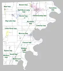
Townships in Arkansas are the divisions of a county. Each township includes unincorporated areas; some may have incorporated cities or towns within part of their boundaries. Arkansas townships have limited purposes in modern times. However, the United States Census does list Arkansas population based on townships (sometimes referred to as "county subdivisions" or "minor civil divisions"). Townships are also of value for historical purposes in terms of genealogical research. Each town or city is within one or more townships in an Arkansas county based on census maps and publications. The townships of Mississippi County are listed below; listed in parentheses are the cities, towns, and/or census-designated places that are fully or partially inside the township. [13][14]
- Big Lake (Manila)
- Bowen (Gosnell)
- Burdette (Burdette)
- Canadian (Huffman)
- Carson (Marie)
- Chickasawba (Blytheville)
- Dyess (Dyess)
- Fletcher (Luxora, Victoria)
- Golden Lake (Wilson)
- Half Moon Lake
- Hector (Dell)
- Little River (Etowah)
- McGavock (Joiner)
- Monroe (Keiser, Osceola)
- Neal (Leachville)
- Scott (Bassett)
- Whitton (Birdsong)
See also
- Island 35 Mastodon
- List of lakes in Mississippi County, Arkansas
- National Register of Historic Places listings in Mississippi County, Arkansas
References
- "State & County QuickFacts". United States Census Bureau. Archived from the original on June 7, 2011. Retrieved May 23, 2014.
- "Find a County". National Association of Counties. Retrieved 2011-06-07.
- "2010 Census Gazetteer Files". United States Census Bureau. August 22, 2012. Retrieved August 27, 2015.
- "Population and Housing Unit Estimates". Retrieved September 28, 2019.
- "U.S. Decennial Census". United States Census Bureau. Retrieved August 27, 2015.
- "Historical Census Browser". University of Virginia Library. Retrieved August 27, 2015.
- Forstall, Richard L., ed. (March 27, 1995). "Population of Counties by Decennial Census: 1900 to 1990". United States Census Bureau. Retrieved August 27, 2015.
- "Census 2000 PHC-T-4. Ranking Tables for Counties: 1990 and 2000" (PDF). United States Census Bureau. April 2, 2001. Retrieved August 27, 2015.
- Based on 2000 census data
- "U.S. Census website". United States Census Bureau. Retrieved 2011-05-14.
- "Dave Leip's Atlas of U.S. Presidential Elections". Retrieved November 18, 2016.
- "Town Crier, Courier News to merge Jan. 1". NEA Town Courier. 2018-12-18. Retrieved 2019-01-11.
- 2011 Boundary and Annexation Survey (BAS): Mississippi County, AR (PDF) (Map). U. S. Census Bureau. Archived from the original (PDF) on 2012-10-19. Retrieved 2011-08-19.
- "Arkansas: 2010 Census Block Maps - County Subdivision". United States Census Bureau. Retrieved May 29, 2014.
External links
| Wikimedia Commons has media related to Mississippi County, Arkansas. |
- . The American Cyclopædia. 1879.
Places adjacent to Mississippi County, Arkansas | |
|---|---|
Municipalities and communities of Mississippi County, Arkansas, United States | ||
|---|---|---|
| Cities | Map of Arkansas highlighting Mississippi County | |
| Towns | ||
| Unincorporated communities |
| |
| Footnotes | ‡This populated place also has portions in an adjacent county or counties | |
| ||

| Authority control |
|---|