Keiser, Arkansas
Keiser is a town in Mississippi County, Arkansas, United States. The population was 759 at the 2010 census.
Keiser, Arkansas | |
|---|---|
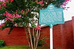 Keiser historical marker at Town Hall | |
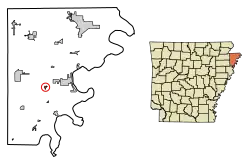 Location of Keiser in Mississippi County, Arkansas. | |
| Coordinates: 35°40′28″N 90°5′46″W | |
| Country | United States |
| State | Arkansas |
| County | Mississippi |
| Government | |
| • Mayor Elect | Eddie Gardener |
| Area | |
| • Total | 0.37 sq mi (0.96 km2) |
| • Land | 0.37 sq mi (0.96 km2) |
| • Water | 0.00 sq mi (0.00 km2) |
| Elevation | 230 ft (70 m) |
| Population (2010) | |
| • Total | 759 |
| • Estimate (2019)[2] | 676 |
| • Density | 1,822.10/sq mi (702.93/km2) |
| Time zone | UTC-6 (Central (CST)) |
| • Summer (DST) | UTC-5 (CDT) |
| ZIP code | 72351 |
| Area code(s) | 870 |
| FIPS code | 05-36310 |
| GNIS feature ID | 0058010 |
History
Originally known as Savage Crossing, Keiser was one of several towns established by prominent late-19th century planter and land developer Robert E. Lee Wilson. The town, which served as a logging outpost and railroad stop on the rail line that connected Wilson and Jonesboro, was named for Wilson's friend, John Keiser. After the forests had been cleared, the town transitioned from a logging town to an agrarian community. The Arkansas Agricultural Experiment Station established a research farm near Keiser in 1957, and built a regional headquarters in Keiser, the Northeast Research and Extension Center, 1980.[3]
Geography
Keiser is located at 35°40′28″N 90°5′46″W (35.674411, -90.096084).[4] The town is concentrated along a stretch of Arkansas Highway 181 southwest of Osceola and northwest of Wilson. Interstate 55 passes just east of the city.
According to the United States Census Bureau, the city has a total area of 0.4 square miles (1.0 km2), all land.
Climate
The climate in this area is characterized by hot, humid summers and generally mild to cool winters. According to the Köppen Climate Classification system, Keiser has a humid subtropical climate, abbreviated "Cfa" on climate maps.[5]
Demographics
| Historical population | |||
|---|---|---|---|
| Census | Pop. | %± | |
| 1940 | 452 | — | |
| 1950 | 522 | 15.5% | |
| 1960 | 516 | −1.1% | |
| 1970 | 688 | 33.3% | |
| 1980 | 962 | 39.8% | |
| 1990 | 805 | −16.3% | |
| 2000 | 808 | 0.4% | |
| 2010 | 759 | −6.1% | |
| 2019 (est.) | 676 | [2] | −10.9% |
| U.S. Decennial Census[6] | |||
As of the 2010 United States Census, there were 759 people living in the town. The racial makeup of the town was 92.0% White, 5.1% Black, 0.4% Native American, 0.1% Asian, 0.4% from some other race and 0.9% from two or more races. 1.1% were Hispanic or Latino of any race.
As of the census[7] of 2000, there were 808 people, 303 households, and 230 families living in the town. The population density was 2,239.3 people per square mile (866.6/km2). There were 334 housing units at an average density of 925.7/sq mi (358.2/km2). The racial makeup of the town was 92.45% White, 4.46% Black or African American, 1.73% Native American, 0.99% from other races, and 0.37% from two or more races. 2.85% of the population were Hispanic or Latino of any race.
There were 303 households, out of which 32.3% had children under the age of 18 living with them, 62.7% were married couples living together, 8.6% had a female householder with no husband present, and 23.8% were non-families. 20.8% of all households were made up of individuals, and 11.9% had someone living alone who was 65 years of age or older. The average household size was 2.67 and the average family size was 3.05.
In the town, the population was spread out, with 26.5% under the age of 18, 6.2% from 18 to 24, 28.0% from 25 to 44, 26.1% from 45 to 64, and 13.2% who were 65 years of age or older. The median age was 38 years. For every 100 females, there were 92.8 males. For every 100 females age 18 and over, there were 94.1 males.
The median income for a household in the town was $35,517, and the median income for a family was $36,940. Males had a median income of $27,679 versus $19,500 for females. The per capita income for the town was $14,769. About 10.4% of families and 10.8% of the population were below the poverty line, including 9.7% of those under age 18 and 21.8% of those age 65 or over.
Education
Public education for elementary and secondary students is provided by the Southern Mississippi County School District, which includes the Southern Mississippi County Elementary School at Keiser. Students graduate from Rivercrest High School located in Wilson.
Notable people
• Ed Bruce - country music songwriter and singer. He is known for penning the 1975 song "Mammas Don't Let Your Babies Grow Up to Be Cowboys"
• Narvel Felts – country music singer-songwriter (active 1957–1988); recognized by the Rockabilly Hall of Fame
References
- "2019 U.S. Gazetteer Files". United States Census Bureau. Retrieved June 30, 2020.
- "Population and Housing Unit Estimates". United States Census Bureau. May 24, 2020. Retrieved May 27, 2020.
- Steven Teske, "Keiser (Mississippi County)," Encyclopedia of Arkansas History and Culture, 2016.
- "US Gazetteer files: 2010, 2000, and 1990". United States Census Bureau. 2011-02-12. Retrieved 2011-04-23.
- Climate Summary for Keiser, Arkansas
- "Census of Population and Housing". Census.gov. Retrieved June 4, 2015.
- "U.S. Census website". United States Census Bureau. Retrieved 2008-01-31.
External links
 Media related to Keiser, Arkansas at Wikimedia Commons
Municipalities and communities of Mississippi County, Arkansas, United States | ||
|---|---|---|
| Cities |  Map of Arkansas highlighting Mississippi County | |
| Towns | ||
| Unincorporated communities |
| |
| Footnotes | ‡This populated place also has portions in an adjacent county or counties | |
| ||
| Authority control |
|---|
