Dell, Arkansas
Dell is a town in Mississippi County, Arkansas, United States. The population was 251 at the 2000 census.
Dell, Arkansas | |
|---|---|
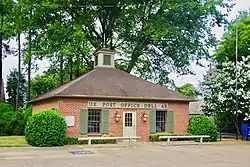 Post office in Dell | |
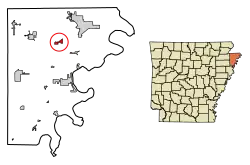 Location of Dell in Mississippi County, Arkansas. | |
| Coordinates: 35°51′25″N 90°2′24″W | |
| Country | United States |
| State | Arkansas |
| County | Mississippi |
| Area | |
| • Total | 1.49 sq mi (3.85 km2) |
| • Land | 1.49 sq mi (3.85 km2) |
| • Water | 0.00 sq mi (0.00 km2) |
| Elevation | 240 ft (73 m) |
| Population (2010) | |
| • Total | 223 |
| • Estimate (2019)[2] | 187 |
| • Density | 125.84/sq mi (48.60/km2) |
| Time zone | UTC-6 (Central (CST)) |
| • Summer (DST) | UTC-5 (CDT) |
| ZIP code | 72426 |
| Area code(s) | 870 |
| FIPS code | 05-18160 |
| GNIS feature ID | 0057638 |
History
Dell has its origins in a community that developed around a loading dock and post office operated by J.B. Richardson in the late 1890s. When the Jonesboro, Lake City and Eastern Railroad completed a rail line through the area, a town was laid out near the tracks. The town was initially known as "Rozell" after an early landowner, but due to naming conflicts with a nearby community known as "Rochelle," the name was changed to "Dell." The town incorporated in 1905.[3]
Geography
Dell is located at 35°51′25″N 90°2′24″W (35.856818, -90.040113).[4] The town lies along the Pemiscot Bayou southwest of Blytheville, Arkansas, and a few miles south of the Arkansas-Missouri state line. Arkansas Highway 18 traverses Dell, connecting the town with Blytheville to the northeast and Manila to the west. Arkansas Highway 181 intersects AR 14 in Dell, connecting the town with Gosnell to the northeast and Keiser to the south.
According to the United States Census Bureau, the town has a total area of 2.3 km2 (0.9 mi2), all land.
Demographics
| Historical population | |||
|---|---|---|---|
| Census | Pop. | %± | |
| 1910 | 162 | — | |
| 1920 | 233 | 43.8% | |
| 1930 | 267 | 14.6% | |
| 1940 | 323 | 21.0% | |
| 1950 | 384 | 18.9% | |
| 1960 | 383 | −0.3% | |
| 1970 | 358 | −6.5% | |
| 1980 | 310 | −13.4% | |
| 1990 | 258 | −16.8% | |
| 2000 | 251 | −2.7% | |
| 2010 | 223 | −11.2% | |
| 2019 (est.) | 187 | [2] | −16.1% |
| U.S. Decennial Census[5] 2014 Estimate[6] | |||
As of the 2010 United States Census, there were 223 people living in the town. The racial makeup of the town was 99.6% White and 0.4% were Hispanic or Latino of any race.
As of the census[7] of 2000, there were 251 people, 115 households, and 73 families living in the town. The population density was 108.9/km2 (282.5/mi2). There were 121 housing units at an average density of 52.5/km2 (136.2/mi2). The racial makeup of the town was 89.64% White, 1.20% Black or African American, 0.40% Asian, 7.97% from other races, and 0.80% from two or more races. 7.97% of the population were Hispanic or Latino of any race.
There were 115 households, out of which 18.3% had children under the age of 18 living with them, 48.7% were married couples living together, 12.2% had a female householder with no husband present, and 35.7% were non-families. 34.8% of all households were made up of individuals, and 19.1% had someone living alone who was 65 years of age or older. The average household size was 2.18 and the average family size was 2.78.
In the town, the population was spread out, with 19.5% under the age of 18, 10.8% from 18 to 24, 23.1% from 25 to 44, 23.1% from 45 to 64, and 23.5% who were 65 years of age or older. The median age was 43 years. For every 100 females, there were 90.2 males. For every 100 females age 18 and over, there were 88.8 males.
The median income for a household in the town was $26,607, and the median income for a family was $31,667. Males had a median income of $26,250 versus $21,250 for females. The per capita income for the town was $15,762. About 10.6% of families and 12.1% of the population were below the poverty line, including 13.3% of those under the age of eighteen and 12.0% of those 65 or over.
Education
It is served by the Gosnell School District,[8] including Gosnell Elementary School and Gosnell High School.
The community was served by the Dell School District until July 1, 1984, when it merged into the Gosnell School District.[9]
References
- "2019 U.S. Gazetteer Files". United States Census Bureau. Retrieved June 30, 2020.
- "Population and Housing Unit Estimates". United States Census Bureau. May 24, 2020. Retrieved May 27, 2020.
- Steven Teske, "Dell (Mississippi County)," Encyclopedia of Arkansas History and Culture, 2016.
- "US Gazetteer files: 2010, 2000, and 1990". United States Census Bureau. 2011-02-12. Retrieved 2011-04-23.
- "Census of Population and Housing". Census.gov. Retrieved June 4, 2015.
- "Annual Estimates of the Resident Population for Incorporated Places: April 1, 2010 to July 1, 2014". Archived from the original on May 22, 2015. Retrieved June 4, 2015.
- "U.S. Census website". United States Census Bureau. Retrieved 2008-01-31.
- "SCHOOL DISTRICT REFERENCE MAP (2010 CENSUS): Mississippi County, AR." U.S. Census Bureau. Retrieved on June 16, 2018.
- "ConsolidationAnnex_from_1983.xls." Arkansas Department of Education. Retrieved on October 13, 2017.
External links
 Media related to Dell, Arkansas at Wikimedia Commons
Municipalities and communities of Mississippi County, Arkansas, United States | ||
|---|---|---|
| Cities | 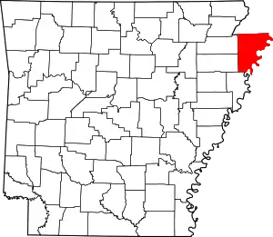 Map of Arkansas highlighting Mississippi County | |
| Towns | ||
| Unincorporated communities |
| |
| Footnotes | ‡This populated place also has portions in an adjacent county or counties | |
| ||