Extreme points of Kyrgyzstan
This is a list of the extreme points of Kyrgyzstan.
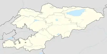
North
South
West
East
Highest
Extreme points of Kyrgyzstan
Cardinal directions
Northernmost point: Sokuluk District, Chuy Region [1][2]
Southernmost point: Chong-Alay District, Osh Region
Easternmost point: Ak-Suu District, Issyk-Kul Region
Westernmost point: Leilek District, Batken Region
Elevation
At 7,439 m (24,406 ft) above sea level, Jengish Chokusu is the highest point of Kyrgyzstan.[3]
At 132 m (433 ft) above sea level, the lowest point of Kyrgyzstan is in the Kara Darya (Kara-Daryya, Karadar'ya),[3] which is a tributary of the Syr Darya, a river that flows into the North Aral Sea.
Notes
References
- Green Finance and Investment Promoting Clean Urban Public Transportation and Green Investment in Kyrgyzstan. OECD. 2019. p. 33. ISBN 978-92-64-34551-5 – via Google Books.
Bishkek is a separate administrative unit (independent city - shaar) and serves also as an administrative centre (apart from 2003-2006) of the surrounding Chui oblast (region), which is Kyrgyzstan's northernmost region.
- http://www.darek.kg/Map
- "KYRGYZSTAN". The World Factbook. Retrieved 1 February 2020.
lowest point: Kara-Daryya (Karadar'ya) 132 m highest point: Jengish Chokusu (Pik Pobedy) 7,439 m
| History |  | ||||
|---|---|---|---|---|---|
| Geography |
| ||||
| Politics | |||||
| Economy | |||||
| Society |
| ||||
| Sovereign states |
|
|---|---|
| States with limited recognition |
|
| Dependencies and other territories |
|
| |
This article is issued from Wikipedia. The text is licensed under Creative Commons - Attribution - Sharealike. Additional terms may apply for the media files.